A Landmark 16th Century World Map by the Guy the Invented the Atlas... Abraham Ortelius
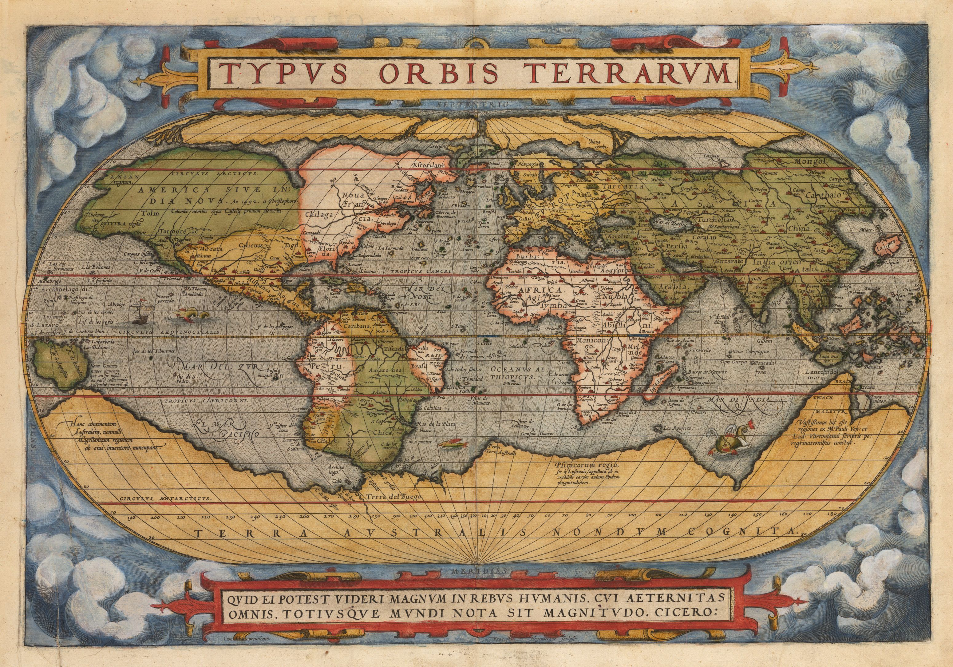
Typus Orbis Terrarum
By: Abraham Ortelius
Date: 1570 (Published) Antwerp
Dimensions: 13.25 x 19.5 inches (33.7 x 49.5 cm)
This important map of the world appeared in 1570 in the Theatrum Orbis Terrarum of Abraham Ortelius, the first known significant collection of maps to be published in one tome, comprising all the elements of the modern atlas. Thus, the map Typus Orbis Terrarum is of fundamental importance to the entire history of cartography.
Ortelius consulted many sources for his map including his friend Gerard Mercator, who urged him to use his own published corpus of research. In addition to the influence of Mercator the obvious influence of earlier works by Giacomo Gestaldi, Gemma Frisius, Laurentius Fries and other distinguished early mapmakers is to be seen in the map.
At the time of the map’s creation the Age of Discovery had been under way for more than a century, Ivan IV (the Terrible) was Czar of Russia, Elizabeth I ruled England and William Shakespeare was six years old. The map depicted is a first edition first state printed in 1570.
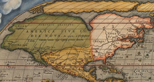
It is centered on the Atlantic Ocean and covers the entire world from the North to the South Pole. His depiction of North America owes much to the work of Mercator, with whom he often consulted. Much of the geography of North America is speculative. Although the continent had been explored to some extent by the Spanish in the early decades of the 16th century, much of what they discovered and charted is not depicted by Ortelius. Despite its discovery by at least 1540, the Mississippi River does not appear on the map, while at the same time, the northeast reveals the discoveries made by Verrazzano and Cartier, with the St. Lawrence clearly denoted. Nova Francia is also named even though Champlain had not yet been born at the time the map was first published, and there is no trace of the Great Lakes.
Many place names north of Mexico correspond to indigenous Indian place names as they had been noted by De Soto and Coronado. The geography of the Pacific Northwest is primarily based on reports of various mythical kingdoms and even reference to places named by Marco Polo, a clear indication of the confusion amongst cartographers of the time regarding the precise geographical relationship between Asia and North America.
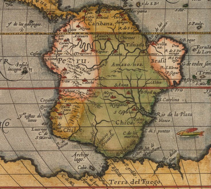
Southwestern and Central America are dotted with settlements and place names familiar today, such as Los Angelos and even the Galapagos Islands, which are shown very close to their actual geographic location. Due in part to the inclusion of the Amazon and De Plata river systems, along with a number of names such as Lima, Cusco and Caracas, South America is fairly familiar despite its bulging west coast. The Andes chain of mountains is fairly accurately depicted, running almost the entire length of the continent.
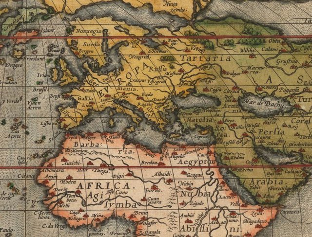
Most of Europe, Africa and Asia are depicted in almost modern form, with countless place names which have not changed over the centuries. While the Caspian Sea (Mar de Bachu) is incorrectly oriented, both it and the Black Sea are depicted. Many famous places are noted and many are omitted. For example, Troy of Iliad fame is depicted in ‘Natolia’ in almost its precise geographic position, while China’s Great Wall is absent.
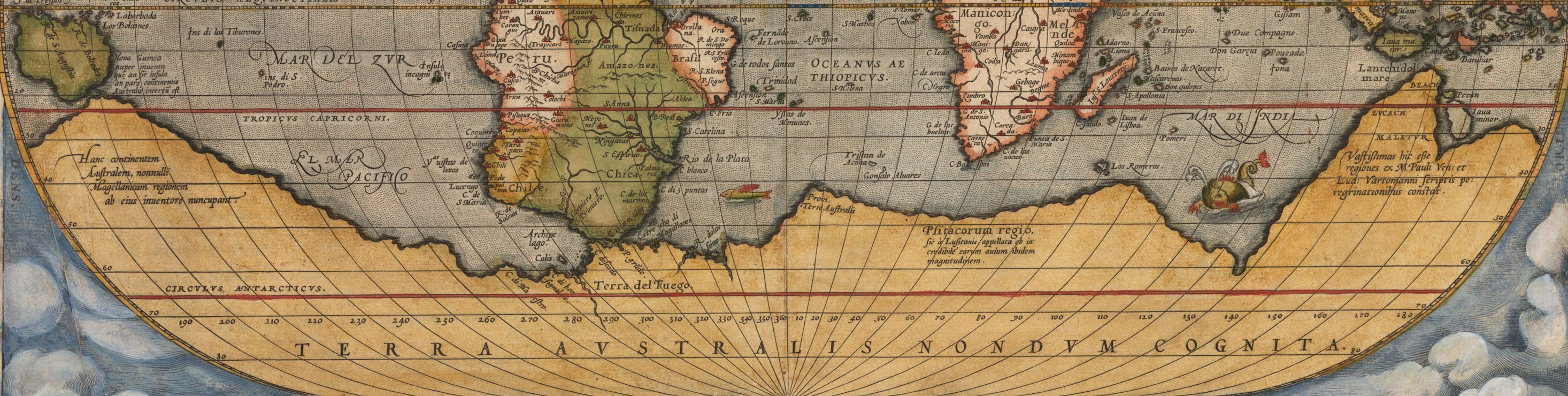
Much of the southern hemisphere is filled by an enormous continent called Terra Australis, which, according to Aristotle’s theory of balance, had long been speculated on as filling a space to keep the globe in balance. At the time the map was published the Americas were seen to counterbalance Europe and Africa, thus the southern hemisphere must have a land mass to counterbalance all of Asia. A frigate plies the Pacific at full sail, and a number of fanciful sea monster/creatures frolic in various parts of the high seas. Along the bottom of the map there is an apt quote by Cicero which says in translation, 'Who can consider human affairs to be great, when he comprehends the eternity and vastness of the entire world?.'
Abraham Ortelius (1527 - 1598) was one of the most important figures in the history of cartography and is most famously credited with the compilation of the seminal 1570 atlas Theatrum Orbis Terrarum, generally considered to be the world's first modern atlas. The map was engraved by Frans Hogenberg (1535 - 1590), a Flemish engraver active in the late 16th century. Along with German cleric George Braun, Hogenberg is best known for his publication of the highly influential city atlas Civitates Orbis Terrarum.
Have questions about this map or would like to see an old map of somewhere else in the world? Comment below.
Like antique maps and history? Follow me on Steemit and visit my website where you can buy antique maps with bitcoin (https://www.hjbmaps.com)
We also sell fine print reproductions at (https://www.thevintagemapshop.com)
Knowledge they say can never end. I have been able to learn new information from your post. Please keep it up. Looking forward to your next post
Gladly! If there is ever an area that you would like to see an old map of, just let me know. I have owned thousands of maps from the late 1400s to the 1980s covering every part of the world. I have researched and imaged all of them and I am happy to share!
Wow, that's lovely. I will see if i have any i wish for and let you know. BY the way , do you work with ArcGIS ARCMAP? I use it alot for digitization of maps.
I do not, but I got into my field of work while taking classes in GIS. I also exhibit at the AAG Conference. I will be in New Orleans this april with a booth full of old maps.
It’s anazing that the Baja peninsula is on there. That means that to some extent the west coast of North America was explored much further north than I was aware of. Obviously Panama and south to Peru and Equador were well explored but that North America’s west coast was detailed somewhat is extraordinary.
The Spanish conquered the Mexican mainland by the early 1500s and Cortez actually reached La Paz by 1535. He was looking for a fabled gold city, but only discovered black pearls. Bummer...
A later expedition was led by Juan Cabrillo in 1542, but that would be the last European venture into the area until the end of the 1500s.
You got a 28.48% upvote from @nado.bot courtesy of @mapman5000!
Send at least 0.1 SBD to participate in bid and get upvote of 0%-100% with full voting power.
Sneaky Ninja Attack! You have been defended with a 7.61% vote... I was summoned by @mapman5000! I have done their bidding and now I will vanish...Whoosh
You got a 4.98% upvote from @upmyvote courtesy of @mapman5000!
If you believe this post is spam or abuse, please report it to our Discord #abuse channel.
If you want to support our Curation Digest or our Spam & Abuse prevention efforts, please vote @themarkymark as witness.
You got a 3.17% upvote from @postpromoter courtesy of @mapman5000!
Want to promote your posts too? Check out the Steem Bot Tracker website for more info. If you would like to support the development of @postpromoter and the bot tracker please vote for @yabapmatt for witness!
I believe i found my map guy. :P
I love maps from ancient to modern times, they are a work of art and the Age of Discovery is one of my favorite times in history.
A very nice post keep it up dude. :)