How a Remote Peak in Myanmar Nearly Broke an Elite Team of Climbers
On one of mountaineering’s most dangerous journeys, a group was pushed to the limit by physical and mental challenges
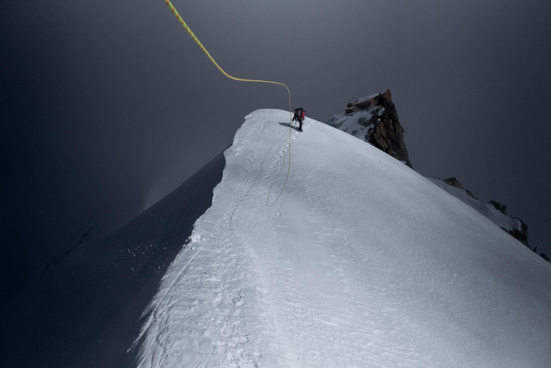
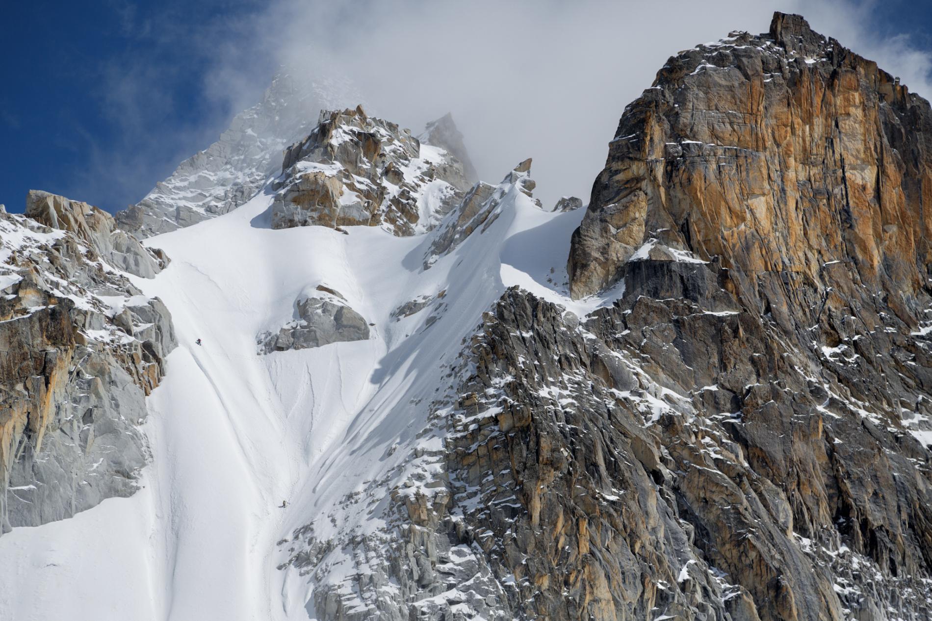
A bone-freezing wind whips the climbing rope as Cory Richards moves up an exposed ridgeline during an attempt to summit Hkakabo Razi, said to be Southeast Asia’s tallest mountain.
PHOTOGRAPH BY RENAN OZTURK
By Mark Jenkins
Photographs by Cory Richards
This story appears in the September 2015 issue of National Geographic magazine.
The wind slams into me, and I desperately grip my ice axes to keep from being ripped off the mountain face. I push my head against the snow, calm myself, and look down. Beneath my crampons is a 5,000-foot drop. It’s like looking down from the open door of an airplane. I am roped to my two companions, with nothing attaching us to the mountain. A fall here would send all three of us plummeting to our death.
When the wind subsides, I pound an aluminum stake into the snow and clip the rope to it. It wouldn’t hold if I were to fall but gives me enough psychological comfort to continue. I concentrate, methodically swinging my ice tools and kicking my crampons. At a rock rampart I place an anchor and belay my partners, Cory Richards and Renan Ozturk, across the chasm.
“Nice lead, dude!” Cory shouts above the roar of the wind when he arrives. He climbs onward, slanting left, searching for a passage up through the granite and snow. When Renan reaches me, there is no room on my ledge, so he traverses out to his own perch. Cory carefully tiptoes the teeth of his crampons along a thin ledge above us and disappears from sight.
Renan and I wait, hunched against the wind. We stomp our feet and painfully slap our gloved hands. We are too far apart to talk. We just stand there, together but alone, on the side of the snow-plastered cliff more than three miles in the sky. After a half hour we begin to freeze. After an hour we can no longer feel our fingers or toes. “I can’t take it anymore,” Renan yells through his frozen beard. “My feet are gone. I have to start moving.”
 Mark Jenkins (standing) and Renan Ozturk pause for lunch within sight of the snowcapped peak of Hkakabo Razi (top left). The climbers hoped to be the first to measure the mountain’s height precisely using a GPS.
We don’t know what Cory is doing above us, but we’re so cold it doesn’t matter. Renan starts climbing, then I follow. We’re all still roped together, so it’s crucial that none of us fall. The rope is supposed to be secured to the mountain to catch a fall, but mortal predicaments like this happen often in mountaineering. When there are no good anchors, your partners become your anchors, physically and emotionally. You must trust your life to their judgment and ability, and they entrust their lives to yours. This is the code of the mountains.
Renan and I halt in a small rock recess overlooking the north face of the mountain. Through blowing spindrift we can see Cory traversing another expanse of snow. It is too dangerous for Renan and me to keep moving. Again, we must wait. We huddle close, but we’re still freezing. The wind swirls around our bodies, howling and biting at us like invisible hyenas. “My feet are turnaround cold,” Renan says. What he means is that they’re close to frostbite.
I wonder, for at least the tenth time on this expedition, whether this is the end of our quest to climb the highest peak in Myanmar—a journey that has pushed us to our physical and emotional limits. Far below us on the mountain, our other team members are pulling for us in spirit. Our base camp manager, Taylor Rees, is at the foot of the mountain. The previous day we left Hilaree O’Neill and Emily Harrington at camp 3, a tent nested on a snowy ridgeline, where our weary team had a bitter argument over who would try for the summit.
I tell Renan to take off his boots and place his feet underneath my down parka, against my chest. He has socks on, and my chest isn’t exactly a furnace, but it’s the best we can do.
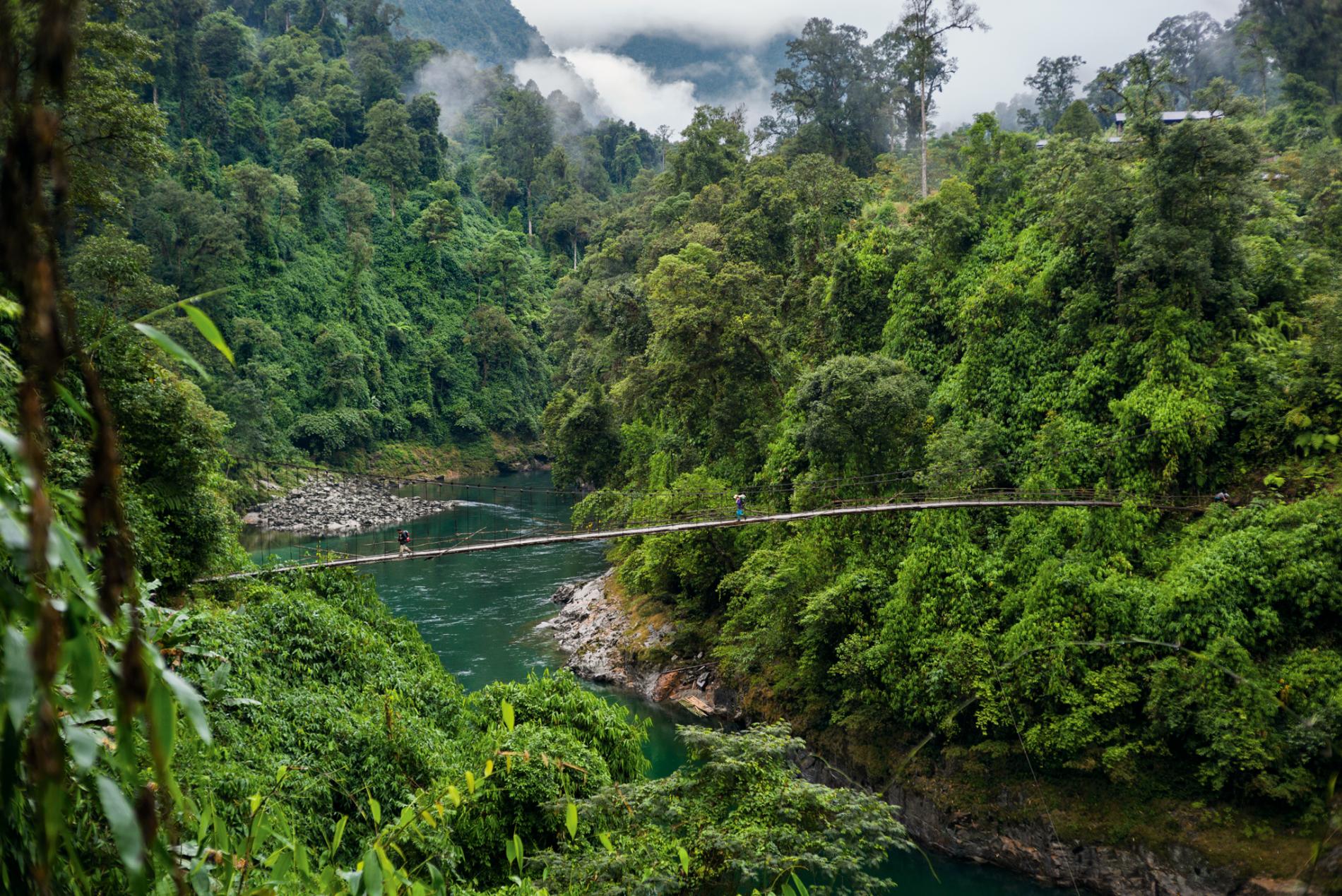 A bridge offers passage over the Tamai River en route to the mountain’s base. The climbers spent weeks pushing through dense rain forest, avoiding snakes and staving off claustrophobia along the dark, tunnel-like trails.
When Cory makes his way around a rock buttress, we start moving. An hour passes before we finally regroup on a thin ledge. Our immediate goal remains far above us—the crest of the west ridge, glistening like the edge of a sword.
“My lead,” Renan says. He begins climbing, woodenly kicking his crampons into the snow. He disappears into the sun. The rope tightens, and Cory takes off. After he vanishes, I follow.
When I reach the ridge and push my ice-crusted face into the sun, it’s like poking my head into heaven. The sudden warmth renews my hope. I pull my body onto the ridge, and a blanket of sunlight envelops me. After the dark, soul-sucking cold of the north face, it feels like rebirth.
Renan and Cory have dropped over the ridge to get out of the wind and discovered a stone platform hanging above the south face. The sun is spread over the rock like honey. “Lunch ledge!” I bellow, christening our aerie.
Within minutes I’ve got our tiny stove roaring. Renan takes off his boots and begins rubbing his toes. Cory gets out his camera and begins snapping pictures. After more than a week of climbing, this is the first time we can actually see the summit: a steep, shining pyramid of snow. But we can also see what we have left to climb: a menacing, serrated ridge of rock and snow, guarded by a dozen dagger-like pinnacles.
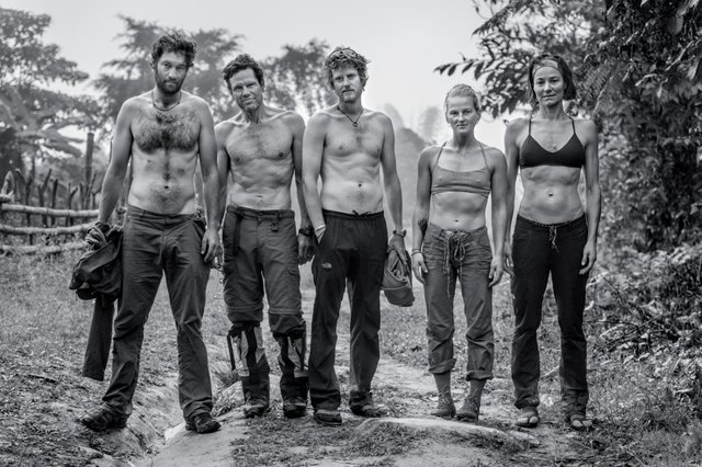 Stretched to the limit, the team—which included (left to right) videographer Renan Ozturk, author Mark Jenkins, photographer Cory Richards, climber Emily Harrington, and expedition leader Hilaree O’Neill—began running low on food on the hike out. “None of us anticipated we’d get that strung out,” says Cory.
PHOTOGRAPH BY TAYLOR REES
“Let’s do an old-school adventure,” Hilaree had said, “an expedition to someplace still remote and unknown.” It was the spring of 2012, and we were coming off Mount Everest. Hilaree is the toughest woman I’ve ever met. After summiting Everest, she climbed its neighbor, Lhotse, with two torn ligaments in her ankle.
We had a lot in common. Both of us had grown up loving mountains. We were both married with two kids and trying to find a way to balance family life with expeditions. And we were both disillusioned by Everest’s commercialism and crowds. We needed to get back to what made us climbers to begin with.
But finding someplace truly remote is tricky. A plane will take you to the North or South Pole, you can hop a helicopter to the base camp of Everest or Makalu, tourist boats cruise the Nile and the Amazon. Real remoteness—somewhere that requires days or even weeks of walking just to reach—has almost vanished from Earth.
And yet I knew a place, a mountain that had long held me in its thrall. But because of my private history with it, I was reluctant to say anything. Eventually, after bouncing ideas back and forth—Pakistan, Papua New Guinea, Kazakhstan—my enthusiasm got the best of me. “What about,” I hesitated, “Hkakabo Razi?”
Hkakabo Razi (pronounced KA-kuh-bo RAH-zee) is said to be the highest peak in Southeast Asia. It is a jagged massif of black rock and white glaciers that rises improbably out of the steaming green jungles of northern Myanmar. Located just beyond the eastern edge of the Himalaya, on the border with Tibet, it was first measured by a British survey published in 1925 at 19,296 feet high. It is a peak so remote, few climbers have heard of it even today. Getting to the mountain would require a two-week trek through dense jungle riven with plunging gorges and inhabited by venomous snakes. Hilaree was hooked immediately. We were planning our expedition before we left Kathmandu.
I had learned of Hkakabo in the 1980s, when I picked up a yellowed copy of Burma’s Icy Mountains by British explorer Francis Kingdon-Ward. It described his 1937 expedition into the region and his audacious attempt to climb Hkakabo Razi solo. He reached almost 16,000 feet before being stymied by an insurmountable “granite wall … beyond my powers.”
Kingdon-Ward’s “powers,” as I learned from reading his many other books, were protean. A brilliant botanist, lyrical writer, indefatigable plant hunter, and purportedly a British spy, Kingdon-Ward was one of those hard-as-iron adventurers in the mold of polar voyager Roald Amundsen or Amazonian explorer Percy Fawcett. Kingdon-Ward could tramp through jungle for months on rice and tea, writing in his journal at night beside a campfire. From 1909 to 1956, he made more than 20 expeditions into Central Asia, during which he survived a fall off a cliff and one of the century’s worst earthquakes. Along the way he collected hundreds of plants and named many, including species of rhododendrons and lilies that now adorn gardens worldwide.
I was entranced by Kingdon-Ward’s journeys and was determined to make the first ascent of Hkakabo Razi. So in the fall of 1993, I enlisted my climbing buddies Steve Babits, Mike Moe, and Keith Spencer. We called ourselves the Wyoming Alpine Club. Mike had been my best friend since high school in Laramie, and I’d met Keith and Steve at the University of Wyoming. Since then, Mike and I had done several first ascents in the Rockies and the first kayak descent of the Niger River in West Africa.
At that time the military junta controlling Burma—later renamed Myanmar—had declared the north off-limits to foreigners. We naively planned to avoid this obstacle by accessing the mountain from Tibet, illegally crossing the border, traveling light and fast with no porters.
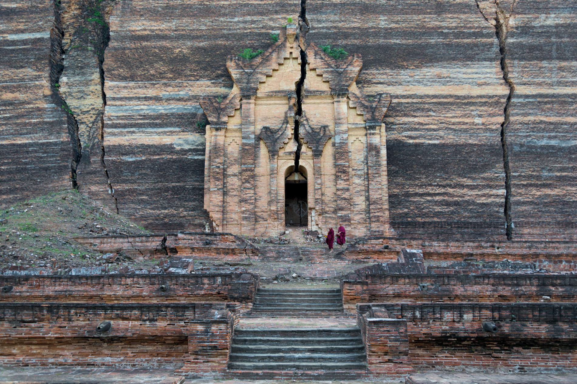 The team’s route passed by religious sites such as the Mingun Pagoda, near Mandalay, in central Myanmar. Construction began in 1791. The facade was later split by an earthquake.
We flew to Lhasa with our rucksacks and proceeded to sneak across eastern Tibet—also closed to foreigners—hitching rides in the backs of trucks and talking our way past checkpoints. It took more than a month just to get near the base of the mountain. Mike and Steve had to return home, leaving only Keith and me to climb. We ran out of food on the north side of Hkakabo and had to descend to a Tibetan village. There we were promptly arrested by the Chinese military, interrogated, and jailed. We signed a four-page confession of “misconduct” and were deported.
Two years later, to my chagrin, the Myanmar government granted Japanese mountaineer Takashi Ozaki permission to climb Hkakabo Razi. Ozaki was an unstoppable Himalayan veteran, having made the first full ascent of the north face of Everest in 1980. (He would die climbing there in 2011.) He made two failed attempts on Hkakabo in 1995, but in September 1996, after two months of climbing, Ozaki summited with Tibetan-born mountaineer Nyima Gyaltsen. He told the Asia Times,“I can say absolutely that Hkakabo Razi is one of the most difficult and dangerous mountains in the world. I was never scared before, like this time.”
Ozaki published a detailed account of his expedition, but he did not measure the summit elevation with a GPS, which left the mountain’s exact height undetermined.
Young and convinced of our invincibility, Mike, Keith, and I talked about returning to Hkakabo. (Steve had moved on to different adventures.) But it was not to be. Mike died on an expedition in 1995, along with his brother and two others. A bowhead whale tipped over their boat in the Arctic Ocean, and they all perished from hypothermia. Mike left behind a wife and three kids. None of us ever quite recovered.
Still, Keith and I continued doing expeditions and often ice climbed together. On January 2, 2009, we were on the fifth pitch of an icefall in north Wyoming. I was belaying him from a small alcove in the ice. He was cheerfully climbing 15 feet below me when we heard a deafening roar. A section of ice above us had cut loose. Seconds later tons of ice crashed down. Keith was killed, his neck broken by the impact.
There was no reason why I lived and Keith died. We’d taken the safety precautions. He didn’t do anything wrong, and I didn’t do anything to save myself. There was no moral, aside from the inescapable truth that mountains are dangerous, and occasionally inflict horror and sorrow on those who dare to climb them.
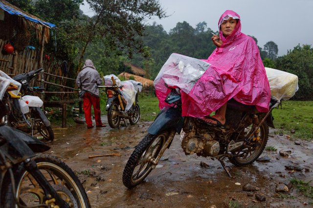 : The climbers hired a caravan of motorcycles in the northern town of Putao to transport their gear and supplies across Kachin state. They rode for three days before the wet and muddy route became passable only on foot.
 Along their 151-mile jungle trek, the team stayed in the homes of local Rawang who live in Myanmar’s far north. Unlike Nepal, where commercial climbing is well established, the people here encounter few foreign mountaineers.
Lounging on our lunch ledge in the sun on Hkakabo Razi, slurping down hot noodles with Cory and Renan, I am reminded of my lost friends. Mike was funny like Cory, who’s kept us going through some of the trip’s worst moments with perfectly timed wisecracks. Keith was quiet like Renan, always taking in the grandeur around him, always the calm voice in the midst of crisis. During these past weeks I’ve spent with Cory and Renan, it’s been a bit like looking back in time at myself and my dead friends. I recognize in these two younger men the same passion for climbing mountains, the same determined toughness, the same boundless ambition, and at moments the same sense of being bulletproof that Mike, Keith, and I had 22 years ago.
Our resolve replenished, we begin to study the crenellated ridge before us that leads to the summit. Because the mountain has remained largely unexplored, we are climbing with little knowledge of the terrain. Even satellite images don’t reveal the true difficulty of the climb. From the lunch ledge, the route ahead looks more demanding than what we’ve encountered so far.
Hkakabo’s west ridge is a two-mile-long saw blade—a series of stone towers separated by sharp cols of snow. Unlike on some mountains, where you can shoot right up to the summit, we have been climbing up and down the jagged ridgeline the whole way—up a tooth of rock, rappelling down the backside, balancing across a bridge of snow, then up the next craggy pinnacle. We try to identify a potential route, but the spiked ridge weaves like a serpent’s tail so we can’t see all the obstacles. We do, however, spot a notch that looks like the best location to bivouac for the night. We pack up and start moving, trying to stay on the sunny side of the ridge.
It takes us four hours to reach the notch. We are so fatigued that we can barely stomp out a tent platform. Our faces are rimed with ice from breathing so hard. While trying to shove the poles into our tent, the wind lifts it like a kite. We throw in our packs, guy it down, and pile inside.
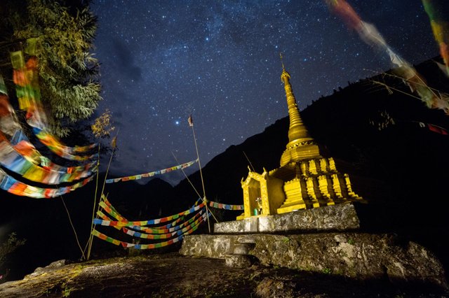 Buddhist prayer flags surround a stupa in Dahongdam, the last village on the jungle trek to the base of Hkakabo. Though Myanmar is 90 percent Buddhist, most communities the team encountered on the route were Christian.
PHOTOGRAPH BY CORY RICHARDS AND RENAN OZTURK
“The shiver bivvy begins,” says Cory as he zips the tent, closing off the screeching blackness that has descended on the mountain.
We knew this night was going to be misery. At camp 3 we could see that the ridge became technical and treacherous. So we ruthlessly cut the weight of our packs, bringing only bare essentials, hoping it would be enough to get us to the top and back down. We left our winter sleeping bags and carried only the thin overbag shells. We have one stove, one fuel bottle, one pot, one spoon, two instant pasta meals, and the three of us are crammed into a two-person tent.
Sitting knee-to-knee, our backs pressed against the tent, we set our stove on our boots and nearly asphyxiate ourselves boiling water from snow. One person holds the stove, another the pot. We are wearing everything we have. Only our headlamps and runny noses stick out from beneath the hoods of our parkas. Renan says little, which is normal. But even Cory is quiet.
We have been sleeping with each other for weeks, like poor brothers in one bed. We know each other’s secrets. I know Renan is dealing with the betrayal of a friend. I know Cory’s struggling to stay married and be a world-traveling photographer. They know I’m haunted by memories of my dead friends, that this mountain is my white whale. My thoughts drift to how close we are to our goal and our team’s ugly fight and the toll it’s taken on my friendship with Hilaree.
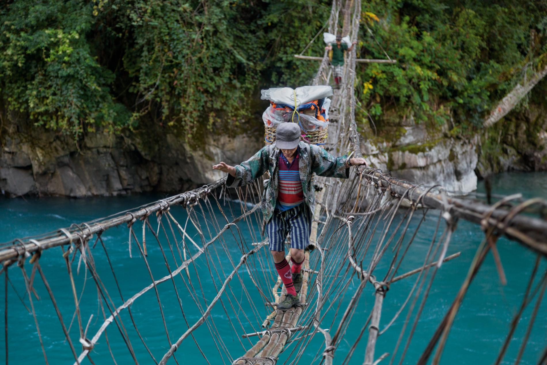 Balancing a 60-pound load, a porter tightropes a hanging bridge. The team struggled to find locals to haul gear. “We had about 35, we wanted about 60,” says team member Taylor Rees. Eventually, they had to leave equipment behind.
Just getting to the foot of Hkakabo Razi took a month. The very thing that Hilaree and I had wished for on the slopes of Everest—remoteness—was the very thing that threatened our expedition from the beginning.
First we had to cross most of Myanmar. From Yangon we took an overnight bus to Bagan, then a ferry up the Irrawaddy River to Mandalay, where we got on a train that bucked and swayed as if it would derail at any moment. In Myitkyina we boarded a plane where a fellow passenger checked an AK-47 as carry-on luggage. On arrival in Putao, the northernmost town in Kachin state, we spent five days “under arrest” while our climbing permits were batted back and forth among officials. Finally, we loaded our gear onto a caravan of motorcycles and set off for three days, crashing through streams and churning through mud until the trail became passable only on foot.
Then began the 151-mile trek to the base of Hkakabo through the wet, dark jungle. The dense forest canopy cast a dim green glow. For two weeks we moved along this tunnel-like track, always rising steeply or plunging suddenly, from one local enclave to the next, exactly as Francis Kingdon-Ward had done 77 years earlier.
We slept in the bamboo homes built on stilts of the Rawang people. Although Kachin state is known for its jade and gold mines and for illegal logging, people this far north mainly raise pigs and chickens and grow little plots of rice.
On the first day trekking in the jungle Hilaree was almost struck by a snake. She saw it coiled on the trail at the last moment and leaped over it. Poised to strike, the serpent’s flat head floated side to side, its black tongue squirting in and out. We all kept our distance except Cory, who knelt down and began snapping photos. “White-lipped pit viper,” he declared.
It was one of a dozen snakes toxinologist Zoltan Takacs had warned us about before we came to Myanmar. If one of us were bitten, the venom could cause bleeding from the nose, eyes, gums, and rectum and could be fatal. We carried two antivenoms, one for vipers, the other for cobras and kraits, but Takacs had warned us that relying on antivenom in the jungle was dicey.
 Porters take a break on a bed of bamboo leaves. In some villages, the team hired entire families, even grandparents, to carry gear. Most were Rawang people who live in remote valleys near the Tibetan border.
Far less dangerous were the leeches. They would drop down onto our necks as we pushed through wet branches or suck onto our feet and legs during stream crossings. All day we’d pluck their blood-engorged bodies off our skin, leaving bites that didn’t fully heal for weeks.
And then there were the spiders. We continually pushed through cobwebs the size of fishing nets. Some held spiders baring fangs so large they were visible from a few feet away.
The Rawang were not immune to the vagaries of the jungle. In one village a distraught mother brought a screaming child to us, her tiny body swollen from infected bites. Hilaree and Emily smeared antibiotic cream on her arms, legs, and face. When I asked what would become of the child, a tribal elder told me, “Everyone here either gets better on their own or dies.”
The legs of one of our youngest porters, a schoolgirl of about 12, were so welted with bites that her skin was as bumpy as a toad’s. She was one of three girls of similar age whom we shamefully hired, along with their brothers, parents, and grandparents, to carry our gear. We hired anyone we could find. They all hefted loads with practiced efficiency. We’d recruit porters from one village to help us get to the next village up the trail. Some would work for a few days, others just for a few hours. Sometimes they’d abandon us without a word, slipping away in the night.
The truth is, we had brought far too much stuff—cameras and lighting equipment, laptops, extra batteries, even two drones to get aerial footage—the paraphernalia of a modern expedition. But it was all useless without enough strong backs to carry it. So we began leaving bags of gear in the villages we passed through until we were down to a quarter of our initial load.
At almost any other time, we would have encountered plenty of locals along this trail willing to make $15 a day, twice the local wage. But when we arrived in the fall of 2014, Hkakabo Razi had improbably become front-page news.
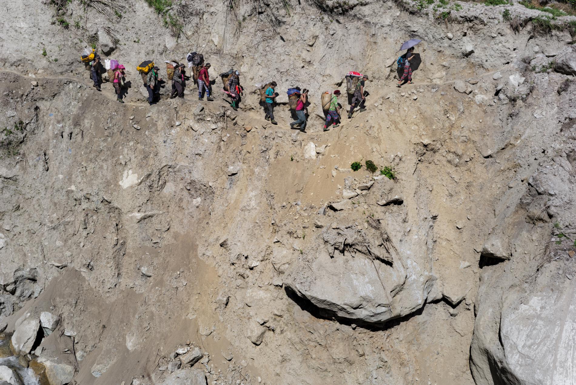 Stepping cautiously, porters follow a narrow trail cut into the side of a ravine. “One slip and you were a goner,” says Mark, who had previously attempted Hkakabo in 1993. “There are so many ways to die before you can even see the mountain.”
On September 10, 2014, three weeks before our team left the United States, an Associated Press headline read: “Search for missing climbers begins in Myanmar.” An eight-man, all-Burmese expedition had set out for Hkakabo to put one of its citizens atop the country’s highest peak. It was a matter of national pride. On August 31, after two weeks of climbing, two team members signaled from somewhere near the summit. They were never heard from again.
An enormous search effort was mounted. Porters were recruited from local villages to supply the search teams. Choppers buzzed over the jungle between Putao and the mountain. Then one of the helicopters, with two pilots and a passenger, disappeared. The search for the climbers was suspended, and a search for the helicopter ensued. Nine days later, the helicopter’s passenger stumbled out of the jungle and led rescuers to the pilots: One was alive but severely burned, the other dead.
After decades of quiet obscurity, Hkakabo Razi had claimed three lives in one month.
Another American climbing team was partly behind this sudden Burmese attention to the mountain. The year before, Andy Tyson, a Teton-based guide, had led an American-Burmese expedition to a neighboring peak called Gamlang Razi. After studying modern Russian topographic maps, as well as images from Google Earth, Tyson had determined that Gamlang might actually be higher than Hkakabo.
Tyson’s team made the first ascent of Gamlang Razi in September 2013. Using a survey-grade GPS, they measured its height at 19,259 feet. Although this was still 37 feet lower than Hkakabo’s 1925 British survey height of 19,296, it was higher than the 18,671 feet that Russian surveyors had calculated in the 1970s and 1980s.
“No one in Burma wanted to believe that Gamlang was higher than Hkakabo,” Tyson told me last year, noting that Hkakabo is a long-revered symbol of national pride, and a foreigner calling its prominence into question embarrassed some Burmese. (Tragically, Andy Tyson was killed in a plane crash in April.)
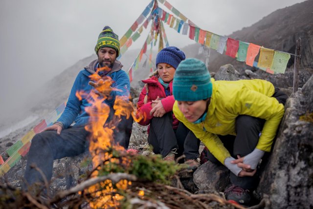 Near base camp, Renan, Emily, and Hilaree found Buddhist prayer flags. Following a Himalayan mountaineering tradition, they burned juniper boughs for good luck. Weeks before, two Burmese climbers had disappeared on Hkakabo Razi.
 Renan descends a slope after finding the route impassable. Negotiating the region’s maze of unmapped ridges and false summits forced the team to backtrack twice, squandering precious time and energy.
In fact the Burmese expedition had set out to prove that Hkakabo Razi was still the country’s highest peak. Before disappearing on the upper reaches of the mountain, their ill-fated climbers had transmitted a GPS reading of 18,996 feet.
In my own research, I had contacted Robert Crippen, an Earth scientist for NASA. We discussed the various methods for measuring Gamlang and Hkakabo. “The real bottom line is that errors of 30 meters [100 feet] or more might not be evident, and this is about the difference in these peaks,” he said. “So we have evidence, but no proof, for which one is higher.”
The highest mountain in Myanmar would remain a mystery until someone stood on the summit of Hkakabo with a GPS.
Renan, Cory, and I pass the spoon, each of us gulping down hot soup, while the wind punches at the tent like a boxer working a heavy bag. When the pot has cooled, we hand it around and swill the last of the liquid. We pack snow inside the pot, put it back on the stove, and keep melting snow until each of us has a full hot water bottle, which we will sleep with on our chests. It is so cold we would prefer to just stay locked together around the purring stove all night—screw the toxic fumes—but we don’t have enough fuel. We turn off the stove knowing that the next hours will feel like several days.
We arrange our ropes and packs underneath ourselves and try to find some way we can all stretch out. If we lie on our sides, it’s just possible.
“Nothing I like more than spooning with two really smelly dudes,” Cory quips.
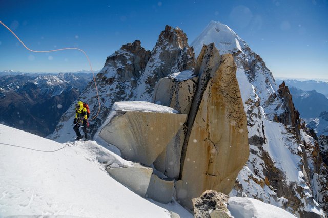
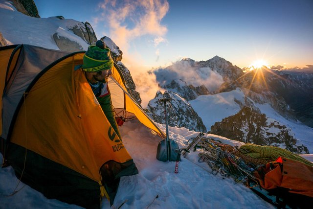 At dawn on a ridge near the peak of Hkakabo Razi, Renan prepares for the team’s final push to reach the summit. In 1996 Takashi Ozaki and his climbing partner Nyima Gyaltsen became the only mountaineers confirmed to have successfully reached the summit of Hkakabo Razi.
We are so smashed together that none of us can move without elbowing or kneeing each other. We don’t expect to sleep. We expect to suffer. We pull our balaclavas down over our faces like knights closing their visors in preparation for battle. We put our mittens beneath our hips to insulate them against the snow.
Renan and I are on the outside, up against the frost-covered tent walls, while skinny Cory is in the middle. It’s like being buried together inside a small tomb. We lie there for hours, each of us floating in our own dark thoughts.
“I’m freezing,” I say in the black of night. I have been trying to hold it in for a couple of hours. My back has been against the tent wall for so long the cold has penetrated through to my chest. “I need to start the stove or something.”
“Get in the middle, I’ll take the outside,” says Cory. We trade places, and I don’t get warm, but I don’t get any colder. We stay in this position for as long as we can stand it. In the darkest, coldest hour, I start imagining someone finding our bony bodies lined up in the snow like crooked logs. Finally, finally, daybreak comes.
 A snow-swollen couloir threatens to envelop Hilaree (left) and Emily (below) as they ascend its powdery flank. The risk from avalanches and rockfalls increased as the team moved higher up the steep, fog-shrouded terrain.
Back in the jungle, two days before reaching base camp, we met a bone-weary, hollow-eyed Japanese team that was retreating from Hkakabo as if returning from the front lines of an epic battle. We’d heard about them and had been concerned that they’d summit ahead of us, rendering all our efforts meaningless before we even got to see the mountain. But they’d been delayed by the rescue of the Burmese climbers. Eventually, they had made their own attempt via the west ridge, which was also the route we intended to take.
Their team leader, Hiro Kuraoka, was injured. He had slipped among the boulders and badly bruised his buttocks. Despite lying in a sleeping bag with a bulging hematoma on his backside, Hiro was animated and generous, explaining their route in detail and showing us numerous photos of the topography from various camps. He said they had been stopped several hundred feet from the summit by a razor’s edge of snow and sharp, insurmountable pinnacles.
Like two military platoons passing in the night, we exchanged supplies. We gave Hiro a bottle of ibuprofen, and he gave us stove fuel and ropes. His team was defeated but alive, which in the end is all that really matters.
After nearly two weeks of trekking, we finally climbed out of the fetid jungle onto the rising southern flank of Hkakabo. The tropical humidity gave way to a bracing alpine mist, and we dug into our bags for fleeces and down jackets. We’d all lost weight and were tired from the arduous trek. And we were running out of time. In planning the expedition, we had agreed to be home by Thanksgiving. In Kingdon-Ward’s time, the end point of an expedition was rarely based on a preset date, but in our modern age, time is the least available commodity. We had just 10 days before we had to begin our hike out. I knew Ozaki had needed 25 days from base camp to climb the mountain.
Over the next week, we put in three camps up the spine of the west ridge, but under time pressure and faced with the difficulty of the terrain, relations among the team were fraying. I was especially concerned when Hilaree reached camp 2 dangerously hypothermic. We got her warm, but it was a cautionary moment. The next day, climbing to camp 3, neither Emily nor Hilaree appeared comfortable on the steep, exposed faces of ice and snow and moved slowly.
 Blocked by tooth-like rock spires, Mark turns back from the ridge leading to Hkakabo’s snowy summit. To go on, the team would’ve had to spend a night without food, a tent, or sleeping bags. “We’d have lost digits, if not our lives,” says Cory.
In retrospect we should have expected this slower pace. Emily is a national sport-climbing champion but had little experience climbing this kind of mixed terrain. Hilaree is a renowned ski mountaineer with some challenging alpine climbing expeditions on her résumé. But Cory, Renan, and I have deeper backgrounds in this type of environment. Cory had been the first American to summit Pakistan’s 26,362-foot Gasherbrum II in winter—and survived an avalanche in the process. Renan had been part of the team that summited India’s 20,702-foot Meru Central via the Shark’s Fin, a brutal climb many thought impossible. And over 35 years of climbing, I’d done first ascents in Antarctica and the Rockies, Alps, and Himalaya. These experiences didn’t change any of the inherent dangers, but it did mean we three were able to move faster and implicitly trust each other with our lives as we tried for the summit.
That night, at camp 3, Renan and Cory both privately expressed concerns about climbing any farther with the entire team. We spent the next day in our tents acclimatizing, and there was no way around the painful conversation. In his soft-spoken way, Renan noted that the climbing was going to get more dangerous. It was also pointed out that three people moving fast had the best chance of summiting in the brief time we had left. Emily readily agreed that she was in over her head. But Hilaree was deeply offended and insisted that she should go for the summit. I explained it was an issue of safety for the whole team, but Hilaree was wounded. “I’m going to say one thing,” she said, her voice welling with emotion as she left the tent, “[Expletive] you, Mark, for the vote of confidence.”
Nothing is more damning in the mountains than hubris, yet hubris is fundamental to climbing mountains. All serious mountaineers possess big egos. You cannot take on the risks and constant suffering of big mountains without one. We may talk like Buddhists, but don’t be fooled, we’re actually narcissists—driven, single-minded, masochistic narcissists. Nearly all of us, on some mountain at some time, have defied logic and refused to turn around, as Hilaree was doing now. Some of us have been lucky enough to survive those misguided moments. This may sound harsh, but I’m at a season in my climbing career where openness and honesty trump polite silence, even with my friends.
We were all weary, light-headed from the thin air, and fearful of what lay ahead, and the conversations over the next hours devolved into shouting, accusations, and recriminations. Eventually, Cory couldn’t stand the rancor and said Hilaree could take his place on the summit team. Renan and I were concerned but reluctantly agreed to the new plan.
At three the next morning, as we began to rope up, with a freezing Tibetan wind howling, Hilaree made the correct decision. She said it was too cold for her, reasoning that if she had a second bout with hypothermia, she might endanger the team. She told Cory to go instead.
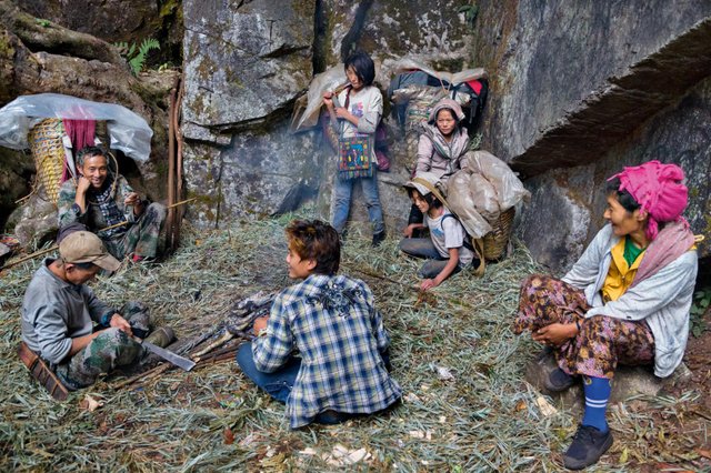
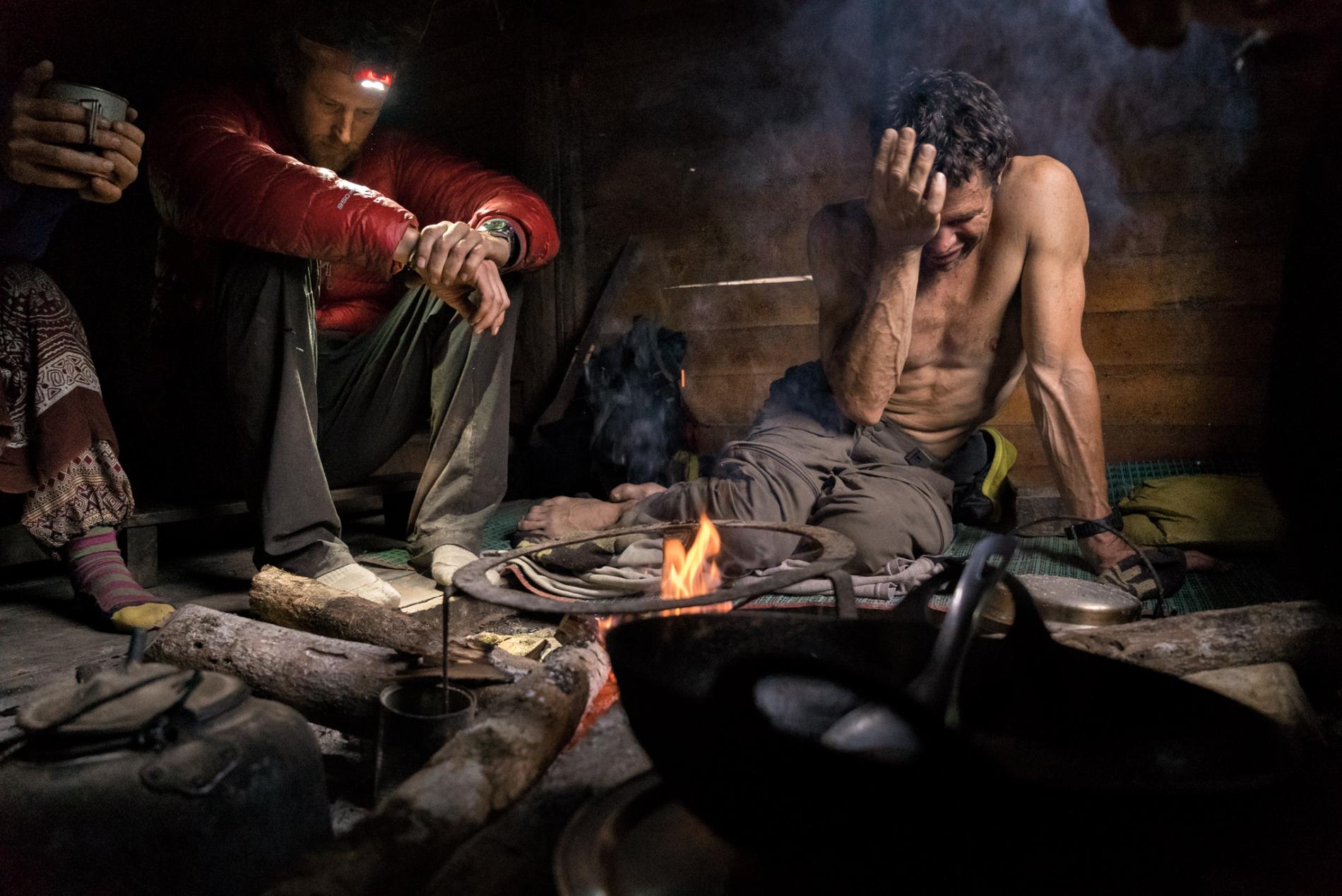 Exhausted and disappointed, Cory (left) and Mark sit by the fire in Pangnamdim, one of the last villages on the trek out of the jungle. “We wanted an old-school adventure, and we got one,” says Mark. As for success? “The mountain always decides.”
PHOTOGRAPH BY RENAN OZTURK
“Why do we do this?” Cory asks, struggling like a contortionist to put his boots on inside the tiny tent. “Really! Why?” His hands are too numb to tie the laces. “Because it’s so much fun,” Renan says drily, pressing his elbows against the snapping tent walls.
After 39 days of boats and trains, snakes and leeches; after clawing up the sheer faces of Hkakabo’s west ridge; today is summit day. We each take slugs of steaming tea until the pot’s empty, then reluctantly crawl out of the tent into the battering wind. Spindrift is whirling around us. The sun is a distant cold ball. We click on our crampons, rope up, and start climbing. Our feet and fingers are numb, but moving beats trembling in the tent. Our blood starts pumping, and warmth gradually returns to our cores.
Together we traverse the first of a series of large rock spires. To either side, a mile below us, is an ocean of clouds. If one of us were to slip off the lance-like ridge, the only way to save his life would be for the next climber on the rope to quickly throw himself off the opposite side, both men praying in the millisecond of potential oblivion that the rope isn’t pulled taut over a knife-sharp rock and severed. This is the depth of trust required in mountain climbing. This is how you transcend yourself and bond with your climbing partners. It is the reason we climb.
We gather on a little point of snow to reassess. “I’m scared,” Cory says. “I’m really [expletive] scared. I think we should turn around.”
His naked honesty is strangely comforting. He’s saying what we all feel. But Renan and I aren’t ready to turn back. I lead down around a snowcapped block, up through a narrow hallway between two slabs of rock, hook along a crescent of snow, and suddenly the entire route to the summit appears before me. I am aghast.
We knew we had one more deep notch in the ridge to negotiate, but I see now that it is filled with massive stone teeth, like the jawbone of a dinosaur. It would take us hours, well into the night, to climb through this wind-gnashed maw. To summit would require another night on the mountain, but this time without a tent, stove, food, or water. We would be perched on a ledge on the side of the mountain in the wind in the dark, and we would freeze to death. It is the point of no return.
I realize we will not reach the top. We will not measure the height of Hkakabo Razi. We will not solve the mystery of Myanmar’s tallest mountain. I have been carrying a photo of Mike Moe and Keith Spencer for the entire expedition. In it, Mike and Keith are standing on a mountain wearing puffy down coats, helmets, and wide grins. I so fiercely wanted to place this picture on the summit. But it is not to be. I paw out a little hole and place the photo in the snow. I take a GPS reading at our high point, 18,841 feet, then climb slowly back along the ridge to Renan and Cory. They already know our expedition is over. All we want now is to get down alive.
This expedition was sponsored by a grant from National Geographic’s Expeditions Council and The North Face.
ဒုန္း ဆား ပ လိ ေဖာ လိုး မီ
လက္ေညာင္းသြားတယ္😃
@luzawjackapril
Good Post!
Thanks for sharing.