Coca leaves on the Machu Picchu Trail
(5:58 am) Ollantaytambo, Peru
Today I start my first day on the Inca trail on the hike towards Machu Picchu. Last night I stayed in Ollantaytambo after arriving early yesterday afternoon. Ollantaytambo is a compound Quechua word derived from "Ollanta" that is a personal name, and "Tambo" that is a Spanish form of "Tanpu" and refers to a city offering lodgings, food, and comfort to travelers. It seems appropriate I should start our journey from here.
I am at a moderate elevation, 2,601 m (8,534 ft), and have been acclimatizing for the past 2 days in Cusco. Upon arrival in Ollantaytambo, I began preparing for the journey ahead. I met our guide and porters and received the final instructions before being left to explore the city.
Ollantaytambo is the jumping off point for almost everyone hiking the trail to Machu Picchu, and I could feel the excitement in the air. As I walked throughout the city streets I watch others preparing for the journey ahead. And, as the night wore on, the excitement everyone felt translated into energy that had to be released. As large groups congregated around various hostels and local motels, you could hear music, laughter, and singing which lasted into the early morning hours.
It is crisp and clear and a beautiful day. I could not have asked for better weather. In a few minutes, I will board a bus that will take me to the starting point at Kilometer 82 where I will sort through my gear and get ready to leave. From there, the road winds down to the gate where I pay my entrance fee ($88 US), sign-in, cross the bridge and set off on one of the most arduous hikes I have ever made.
(11:38 pm) Dead Woman's Pass
I am now at Dead Woman’s Pass and it has been a grueling day. As I began, the trail rose gently uphill through a eucalyptus grove. The incline was gradual and the trail shaded. I continued on through large trees and beautiful valleys until I approached the first set of ruins at Llactapata. Here I took a break to take pictures and just sit in the vastness of my surroundings. From Llactapata I had a commanding view of the entire valley and it made me feel very small. Several farmers could be seen working in the rolling countryside, and just out of sight you could hear the Rio Cusichaca, which is a tributary of the Urubamba. At times, this raging river plunged underground and ran unnoticed. As I marched ahead past Llactapata the trail began to rise. It was also at this point that it began to rain. I found shelter under a lean-to alongside the road, but as the rain stopped, I continued on down the road.
I stopped for lunch at the small village of Huayllabamba. Here locals sit out next to the trail offering cold drinks, food and other assorted goodies for sale. My lunch consisted of a local fare including bread, fruit, cheese, rice, and tea. There was plenty and I were grateful.
For me, the hardest part of the hike started immediately after lunch. My guide asked if I wanted to pass up the first campsite and proceed to the bottom of 'Abra de Huarmihuanusqa,' or 'Dead Woman's Pass.' He said this would put the hardest part of the trail behind me and allow me to ease through the remaining days. Because my strength was holding and I still had a great deal of enthusiasm, I decided to take the recommendation and proceed straight to campsite #2.
Just after Huayllabamba the trail turned northwest up the Llullucha Valley. I realized immediately I was in for a much harder hike than anticipated, and I was right. I marched on through a steep thicket of lush, sub-tropical vegetation that gave way to woodlands. The incline was dramatic and I became fatigued rapidly. The incline continued for well over an hour until it dropped down to a clearing. This was the first campsite along the trail, and the one I had decided to pass. By the time I arrived at campsite #1 it was a virtual tent city with large groups staking out the best sites. Still, I moved on.

At the first campsite, I fell in with an Aussie traveler. As we left the meadow the path began to enter the woodlands. It was beautiful. The trees were hung with moss and looked like large mushrooms or stocks of broccoli sticking out of the ground. Still, even with all the beauty around me, I could not take my attention away from the path in front of me. The trail continued up steeply with no end in sight. The Aussie and I would walk for a while and then stop and talk. Continuing ever so slowly to campsite #2.
He was a very nice fellow and told me a story about an American woman hiking alone in Tibet. She was walking very fast and ahead of everyone when she fell off the side of a cliff. It was some time before anyone realized she was missing and when they backtracked, they could barely hear her inaudible cry for help. She had broken her leg and back. As the story was being told, I slipped and almost went over the edge. As I looked down I realized I could have had a similar fate. Still, we continued on, stopping every so often to catch our breath, stuff more coca leaves in our mouths or to bitch about the difficulty of the trail.
The day began to run long and become very cold. The trees were still offering a little protection, but were becoming less abundant the higher we climbed, and the chill from the late afternoon was starting to have an effect. As we came out of the trees and turned inward towards the spiral of the peak, we found ourselves entering another large meadow at the base of Dead Woman's Pass. We could see numbers of people who had arrived earlier setting up their campsites and quickly putting on warmer clothes for the night ahead. We also saw the first toilets we had seen on the trail as well as sinks and showers. As we walked towards the back of the meadow, we continued ascending higher. I noticed a large group of llamas, horses, and mules being herded down out of the highlands for the night. This did not comfort me thinking of the night ahead. A moment later I caught sight of my guide. He had arrived about an hour ahead of me. Still, during that time, the temperature had dropped 20º and we were all very cold.
As I began to rest I became very nauseous and developed a tremendous headache. I had stopped chewing coca leaves earlier and now realized that had been a mistake. The leaves are considered to be very effective for dizziness, headaches, sore throat and stomach problems. It is also taken by almost everyone on the trail to combat "soroche" or altitude sickness. I immediately found my bag of leaves and began the ritual again. They taste horrible but unfortunately, they are necessary.
I set up my tent and immediately laid down to rest. I felt horrible. I was unable to eat, very tired, and getting cold. I think if I had continued chewing the coca leaves and had slowed my pace the entire day I would have been all right. As the evening passed, I began to feel better. I still had not eaten and was getting very hungry. At around 10:00 pm and was able to get some soup and half an omelet sandwich which made me feel much better.
(7:35 am) Dead Woman's Pass
This morning I woke when my guide came to my tent with a cup of warm water for tea, some coca leaves and warm water to wash my face. As I crawled out of my tent, I noticed the sun had risen and was warming the air from the night before. I also saw large groups of hikers that were already packing up and heading for the trail up to “Dead Woman’s Pass.” I still had to have breakfast and break down my camp, so I had time to look around and take in the scenery. I am now high up in the Andes. The view is eminence and hard to fathom at times. As the sun begins to push out the cold I again start to shed layers of clothing from the night before, and after I eat, I will pack up and start out towards my highest elevation 4,200 m (13,782 ft), through "Dead Woman's Pass." This time, however, I will go slowly, "Despassio!" One foot at a time, thinking of nothing other than breathing and moving forward.
(9:50 am) Runkuracay Ruins
I am presently stopped at the Runkuracay Ruins. It took me nearly 2 hours to get here from our campsite at the base of Dead Woman’s Pass. The trip up was slow and methodical. I simply put one foot in front of the other, not really looking up while I walked. Once there, I could see the excitement on everyone’s face. I was so glad to have made it. Everyone was taking photos, laughing, and smiling and just absorbing the view. As I looked away from the Pass I could see the small line, like ants, of people who were already moving down the other side of the Pass. I stopped for only a short time, and like everyone else, I knew my trail continued. I still had a full day of hiking to get to my next campsite.
From here I will continue back up to the left of Runkuracay near a small lake and over the second pass, at 3,716 m (12,192 ft). Much of the time I will be on Inca steps, and the descent down the steps will be very steep. My guide has told me that at the base of these steps I will start to see signs for Sayacmarca. These ruins lie about an hour from the top of the Pass and their name means 'the Secret City’, which is fitting.
(7:20 am) Camp Two
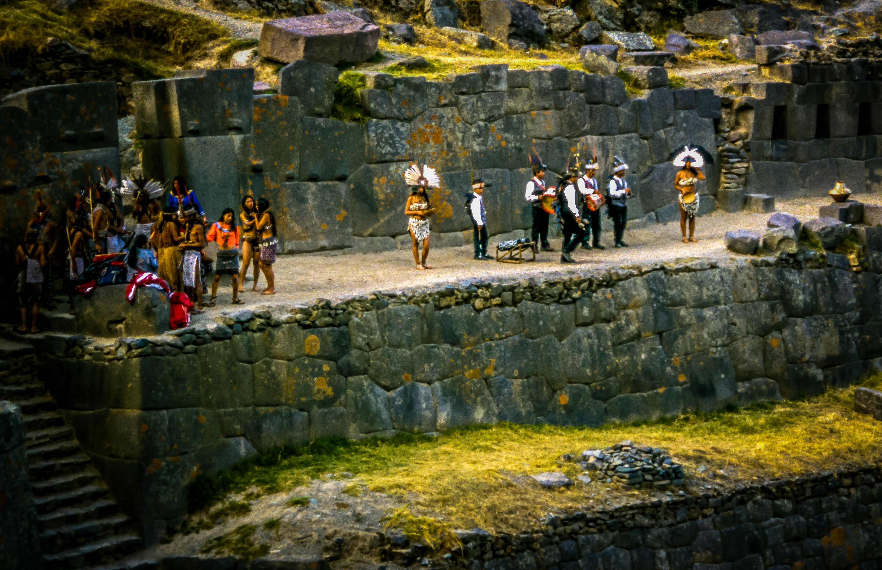
Like so many Inca ruins, no one really knows the purpose of Sayacmarca, but it commands a prominent view, located at over 3,505 m (11,500 ft). In spite of the difficult terrain, there is an aqueduct carved on the mountain crest, fountains that seem to have had a ritual purpose, narrow streets, and a semi-ovoid building. It appears this site must have been strictly administrative or ceremonial, perhaps for the management of the territory and the nearby roads. Thus, it is possible that soldiers, state officials, or priests, who were not farmers as there are no farmlands around, could have inhabited these buildings.
From Sayacmarca, the trail continued down into the valley. Stone steps made for easy walking. Around the bend from Sayacmarca was where I found our second campsite. This site was a far more pleasant than the previous night. It was not as cold and I felt much better. Again I found toilet facilities, but they were in very poor condition. When I woke this morning, I started packing for the short hike to camp 3 near the Wiñaywayna Visitor’s Center. It should only take a half-day to get there which will give me ample time to explore the area and rest for the early morning march to Machu Picchu.
(12:45 pm) Wiñaywayna Visitors Center
This morning, from camp 2, I continued on the trail carefully paved with flagstones and came upon a wide tunnel carved in the mountain rock. It was about 18 m (60 ft) long and had carved steps through the mountain. As I advanced along the trail I again started gaining altitude and found myself above the next set up ruins at Phuyupatamarka. This was at just over 3,657 m (12,000 ft). This site was named "Phuyupatamarka" meaning “Spot over the clouds” because it is almost always covered with a fine mist. It was constructed on a perch that dominates visually a broad territory and must have been an important religious and administrative center.
From Phuyupatamarka I came down to Wiñaywayna, and the Wiñaywayna Visitors Center. These buildings offer basic lodging and eating facilities for those wishing a more traditional stay, but I had already decided to camp towards the southeast is the Wiñaywayna ruins that hang over the Urubamba canyon.
After exploring the site I decided to make my way back to the visitor’s center to find a place to camp. I was upset to find most of the campsites already taken and I was forced to place my tent along a very steep ledge. I had enough room for my tent and about 1 ft of walking room around the tent; and if I fell, I would fall a long way down. It gives going to the bathroom in the middle of the night a whole new meaning. After setting up my tent and dropping off my gear, I ended up in the hostel playing cards for several hours. I knew I had to get up the next morning at 4 am so I took it fairly easy.
(6:50 pm) Aguas Calientes, Peru
This morning I was awoken by the sound of people shuffling by my tent. As I mentioned, there was not much room to get by so every time someone past, they would brush up against my tent. This started at about 3 am. I laid there for about an hour and then started to pack my gear. I still had a 3-hour hike to reach the Sun Gate at Machu Picchu before sunrise. Everyone wanted to take pictures just as the light of the day was reaching out across the Andes and striking Machu Picchu.
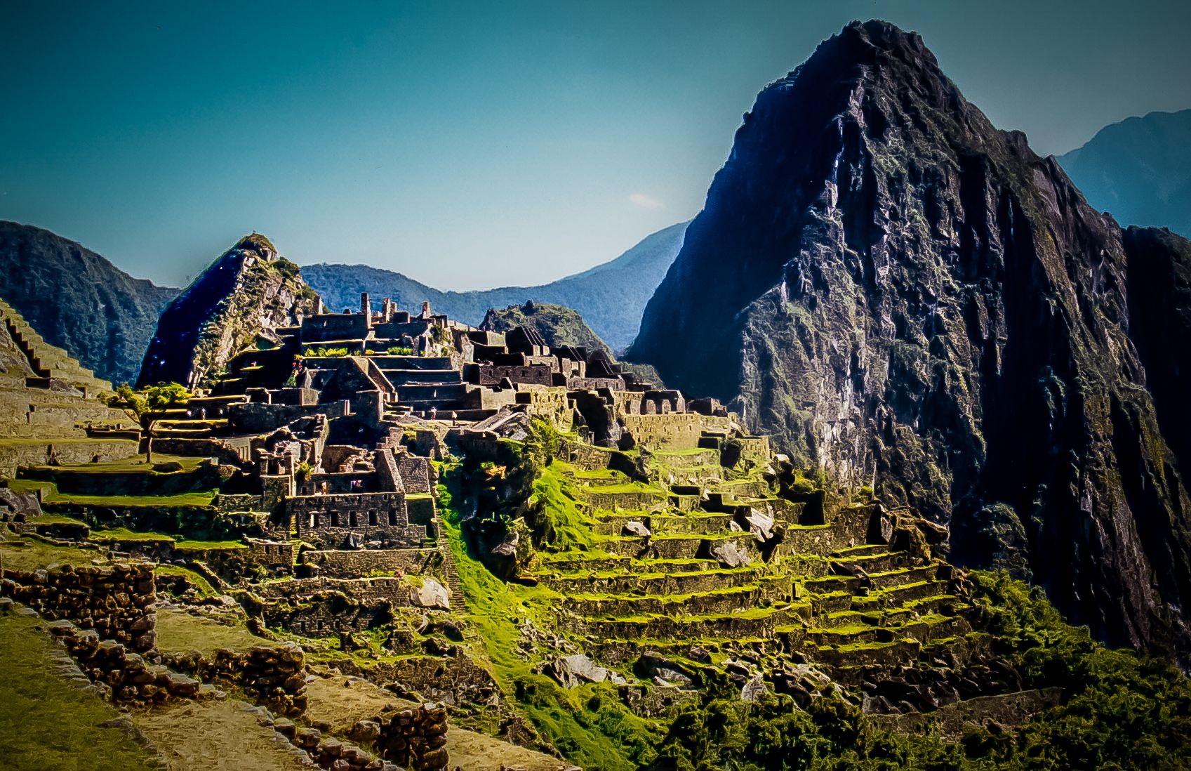
The hike over became a mad dash. Hundreds of people were making their way along the narrow trail. Everyone wanting to reach the Sun Gate before the next and position themselves in the best spot for photos. No one wanted to be passed and everyone wanted to pass the person in front of them. It was amazing to watch the energy of the people take control and spirit the mass forward. For the next several hours this movement would continually push those few who had taken the challenges of the trail forward. Their reward was the most spectacular view imaginable. As the glow of the morning began to creep over the eastern peaks, the faint outline of Machu Picchu could be seen in the distance. It was amazing. I could not believe its size or how delicate it seemed. This beautiful city, perched on top of a mountain.
As I sat waiting for the sunlight to expose its complete beauty, I drifted into a meditative state. Then, as the sun started to shine and the darkness fade, the clatter, and zip of hundreds of cameras began clicking off simultaneously. It was like hundreds of gnats swarming your face. I could only take it for so long. I took my photos and then sat as the light completely illuminated the ruins. Slowly, I made my way down towards Machu Picchu.
My guide showed me around for a couple of hours explaining the history and nuisances of the site. I then had a few hours to roam by myself. During this time, I climbed the adjacent peak of Huayna Picchu. From there; I had a tremendous view. The city was enormous. While I had a great view, moving about was tricky. There was not enough room on the jagged peaks to accommodate all the people, and if you took a wrong step, it could be deadly. Before I had started, the guard told me it was slippery and very steep. They made me sign in and write down the time. I was told that once I came out, I needed to sign out as well. This way if you were injured and didn't come down, they would know to come look for you. The guard wasn't kidding about it being wet and slippery. It was a very narrow path with water draining down from the top turning the path into a slide. I slipped many times even though there was a chain on many sections of the path to keep you from falling.
After I finished exploring the city, I sat down by the 'snack bar,' I mean really, it wouldn't be tourism if there wasn't a snack bar, and just had a brief moment. I had completed the hike. I had a great sense of relief. I just sat my own filth and stench looking around with a stupid grin on our face. After 4 days on the trail with minimal facilities, I was very dirty and I am sure that I was smelly. As I sat there, buses of tourists started making their way up the hill from the city below. Aguas Calientes, provides the less adventurous an easier way to view Machu Picchu. You simply take the train from Cusco straight there. Then, the bus brings them up the hill. As the bus doors opened, hordes of people began invading our precious territory. In fact, as I sat there watching perfumed women, well-groomed men, and very loud children get off the buses, I heard one very brightly colored woman say, "These people sink!" I could only laugh.
From there I took a bus down to Aguas Calientes where I sat in a bar for over 6 hours, playing spades and drinking beer. I am waiting for the next train to take me back to Cusco.
Overall the trip was exciting and amazing. Even with all the difficulties that I encountered, it was well worth the effort. Still, I made it. I strongly recommend this trip to anyone with an adventurous spirit. I cannot tell you how it has made me feel.
Congratulations, Your Post Has Been Added To The Steemit Worldmap!
Author link: http://steemitworldmap.com?author=liquidtravel
Post link: http://steemitworldmap.com?post=coca-leaves-on-the-machu-picchu-trail
Want to have your post on the map too?