Sabang, Enchantment of the Beauty of Indonesia's Most Western Island
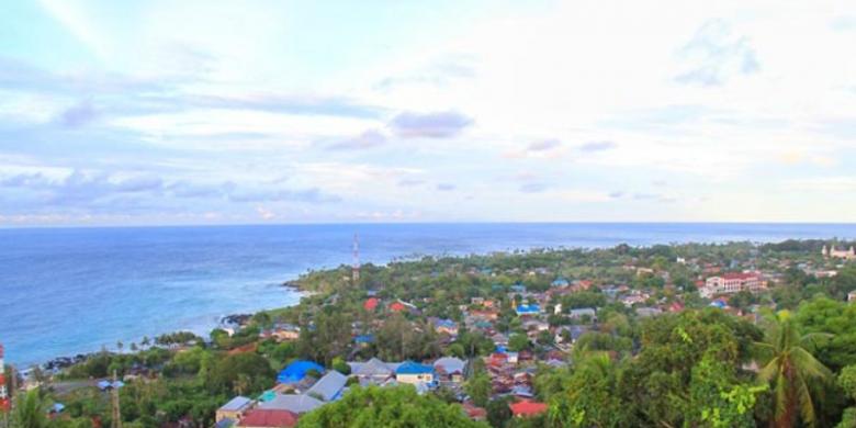
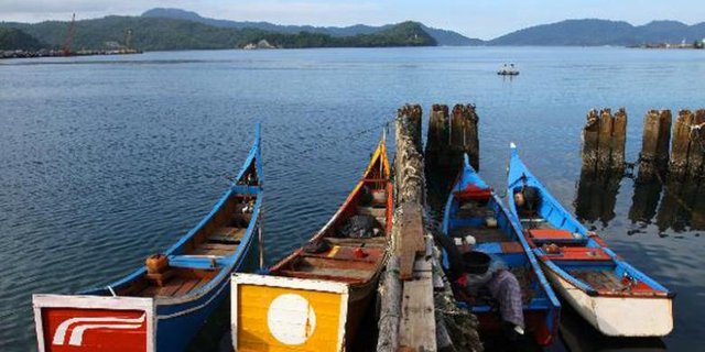
Sabang is a city located on Pulau Weh and is a gateway in the western tip of Indonesia. Sabang has an area of 156.3 square kilometers with the highest peak of 617 meters above sea level. Because it is located on Pulau Weh many people call Pulau Weh as Sabang Island. Weh Island itself is the main and largest island separated from the mainland of Aceh by the Strait of Bengal. Besides directly adjacent to 3 countries namely Malaysia, Thailand and India, Sabang is also a very unique area for Indonesia. That's because here you can find Zero Kilometer monument which is the forerunner of the term, "From Sabang to Merauke". Currently Sabang transformed into a marine tourism destination Indonesia that offers a paradise for divers. Here you can enjoy the underwater nature by diving to discover hundreds of species of fish and the richness of natural reefs that are not planted or cultivated. The waters in Sabang are the meeting place of the Indian Ocean and the Malacca Strait. Currently Sabang equip tourist attraction by organizing Sabang International Regatta.
This article has been broadcasted on Kompas.com under the title "Sabang, The Enchantment of the Beauty of the Most Western Island of Indonesia"
Sabang's charm offers the beauty of a beautiful coastline, nan blue and clean sea water and green trees. However, not only marine tourism can be found in Sabang. There are mountains, lakes, beaches, sea, as well as the forest is still natural and awake waiting to be visited. Not to mention your interaction with the local community will provide a memorable experience. Sabang is a beautiful small town with a hilly land structure so locals call the city of Sabang with two names namely the city down and the city top. Sabang consists of five large and small islands, namely Weh Island as the largest island, Rubiah Island, Klah Island, Seulako Island, and Rondo Island. The population is about 26,000 inhabitants. Sabang is divided into two sub-districts and 72 villages. Topography includes lowland, bumpy, hilly and mountainous terrain, and rocks along the coast. The Sabang border to the east is the Malacca Strait, west to the Indonesian Ocean, north to the Malacca Strait, and the south by the Indonesian Ocean. At the time of the Kingdom of Aceh, Weh Island area itself is a place of expulsion or moved "geupeuweh" for someone who is subject to heavy penalties from the kingdom. The name geupeuweh is then attached to the name of this island and along with the time then the pronunciation abbreviates to Weh and is defined as a separate island.
( )
)
The word "sabang" comes from the Acehnese word "saban" which means equal rights and position in all things. This is attributed to the existence of Sabang, which was once visited by many outsiders to open the garden (seuneubôk) or other business. The arrivals come from different regions with different cultures, both attitudes, values, and customs. Gradually assimilation occurs where the various differences eventually fade and their positions become the same. The term saban has long been attached to Weh Island which then slowly changes its mention to "Sabang". Sabang is the only area of the Kingdom of Aceh that can be fully controlled by the Government of the Netherlands East Indies. Since 1881, Sabang is designated as a natural harbor called Kolen Station. The Dutch East Indies government then built various facilities and infrastructure. Especially after 1887 when Sabang Haven obtained the authority to build a port supporting facility. In 1895, Sabang became a free port area of Vrij Haven managed by Sabang Maatschaappij (Maatschaappij Zeehaven en Kolen Station). At that time the name Sabang increasingly popular in the archipelago and internationally as a port of international trade circulation. World War II had destroyed Sabang until 1942 occupied Japan and made it the maritime base of the Japanese Navy. Unfinished repairs due to war, the physical damage of the island is getting worse after the Allied Troops bombard it so that makes Sabang was close
It was only after Sabang's independence period was established as the center of Navy Defense of the Republic of Indonesia (RIS) and all assets of Sabang Maatschaappij Port were purchased by the Government of Indonesia. In 1965 formed the government of Sabang Municipality and initiated efforts to reopen Sabang Pelabuhan Bebas and Free Trade Area. This effort was officially inaugurated in 2000. Activities Free Port and Sabang Free Trade began to pulsate with the entry of goods from abroad to Sabang Area. However, in 2004 Sabang again stalled because the central government established a state of martial law for Aceh
Hi, I just followed you :-)
Follow back and we can help each other succeed! @hatu
ok friend.
This post has been selected by Altruistic as a post of the day has been given an upvote.
You can join us on her discord server: https://discord.gg/KHB9eJk to know more about what we do and how we can be of help
Please kindly upvote this comment in order to keep us helping plankton and minnows that their quality posts are undervalued.