The Copper Canyon with questionable maps. Part two.

So how far can two overland monkeys with no maps get exploring the infamously labyrinthine roads of Mexico’s Copper Canyon region?It turns out that they can make it pretty far.
The Copper Canyon region actually consists of several different canyons covering an area approximately six or seven times larger than the Grand Canyon in the United States. Some of these canyons are deeper than the Grand Canyon as well. As you can imagine, the landscapes are rather dramatic.
Urique Canyon is the deepest of all the canyons in the region. With 1870m (6135′) variation in altitude from canyon floor to rim, we knew we would be in for some spectacular views.We navigated the same winding narrow road as we had the night before. In the early morning light, the views were more spectacular and the drive was far less daunting.
Although the daylight did serve to highlight the peril we had been in as we cautiously made our way down the hill in the dark the NIGHT BEFORE.


After we had wound our way out of the canyon, the next goal was to find some petrol. We had left Urique before the service station had opened (if indeed it was going to open at all). We were hopeful that we would find fuel in one of the nearby towns. Which we did, served to us from a 20 litre container by the enterprising lady who also ran a hamburguesa stand in the town of Cerocahui.
Cerocahui was a peaceful mountain hamlet nestled into a bowl-like valley. We couldn’t resist a quick look around town, even though we planned on driving though to Creel that day.

Cerocahui from above

Cerocahui’s main tourist attraction appeared to be this 17th century church.
It was clear that the town’s main industry was forestry, smells of freshly cut pine and smoke from cozy log fires reminded us of winters at home. As did the temperature on the canyon rim. There was a distinctly wintry chill in the air. We wondered how cold it would be camping up here compared with the muggy heat of the canyon floor the night before.
Cerocahui seemed like a pretty friendly town, people tended to smile and wave when you drove past and it seemed rather relaxed. It was perhaps a place that deserved more attention than just a drive through and a stop for a snack. However, not wanting to find ourselves driving after dark again, we hit the road pretty promptly.
Another night-time journey was not actually likely. Since we had arrived in Urique, the roads we were following were looking better and better, the towns themselves had paved roads. Travelling was much faster than on the serpentine unlabelled roads from the day before. It wouldn’t be long before we hit the paved highway to Creel, so we needn’t have been concerned.
Just down the road from Cerocahui was the ‘town’ of Bahuichivo. It is a small village that has sprung up around the nearby train station. There isn’t much there, yet we still managed to take a wrong turn and almost get lost. Which was pretty ironic, given that Javier (our GPS) had now realised where we were and was offering useable directions to Creel, also, we were in a very small town.
As we drove along, Ben became increasingly unnerved by the vehicle full of heavily armed young men following us menacingly through the town. Bahuichivo just wasn’t giving off the same friendly vibe as Cerocahui.
We pulled over to let them pass and started the search for somewhere to have lunch. This lunch mission accidentally sent us down a one way road, right past the destination of the heavily armed vehicle load of young men. Who it transpired were meeting about 30-40 of their equally heavily armed cronies in someone’s front yard. Neither of us had seen so many guns in one place that wasn’t on TV or in a US department store. At this point we had decided we were definitely not sold on the town of Bahuichivo… we were starting to miss the peace and quiet of the unlabelled back roads.

The road in to Bahuichivo.
We carried on to Creel, hoping it would be a little more laid back and a little less overloaded with gangs of armed youths.
As we drove higher and higher we started to see more ice and snow on the side of the road. After months exploring the sunny Baja Peninsula, we knew it was going to be a chilly night…

Camping in Creel sounded like it was going to be relatively expensive. We used this as an excuse to upgrade to a cozy hotel room, with a heater—our favourite! Luxury!

Again, interesting art work in our hotel room…

It transpires that this is what happens if you bring a back of chips up from sea level to 2,300m.
The town of Creel was another peaceful alpine town, similar to, but larger than, Cerocahui. While the smell of freshly cut pine and the smoke from log fires still hung thick in the air, it was immediately clear that it was a big tourist hub for the area. The main street seemed to consist mostly of hotels, restaurants and gift shops. Yet Creel somehow managed to retain its small town charm.
We laughed when we saw the kids in the fields behind the hotels showing off their bike tricks to one another. Each kid was trying to out do their friends. Then two brothers showed up on their white horse and started doing tricks and showing off their horse-riding skills.
Horses. Way more bad-arse than push bikes.

Better than a push bike…
We used Creel as a base for exploring a few of the local ‘tourist attractions’. There were a number of rock formations to look at nearby. After paying the modest entry fee and seeing the valley of the frogs:

We agree, this one looks like a frog.

Not sure about the rest of the rock formations though. Possibly the use of the plural ‘frogs’ was a bit misleading.
Then the valley of the mushrooms:

Ok, I’m not even going to walk over there. They are just rocks people.
We weren’t really that interested in visiting the valley of the monks, situated another 10km down the road.
Even less so when a chap with a lazy eye and terrifyingly long fingernails wanted us to pay extra money to him to pass by and go see them. (At least we think that is what he wanted—he alternated between mumbling semi-coherently in English and Spanish and accentuated every ‘p’ by expelling a spray of saliva.)
Not wanting to continue the conversation with crazy spitting man, we contented ourselves by checking out the nearby San Ignacio Mission.

Yet another church.
It was yet another church, like many others we had seen already.
Lake Arareko proved to be a bit more interesting. However, it was a bit chilly for a swim and we still haven’t got over the trauma of our CANOE RENTAL IN JASPER, so we merely eyeballed the lake from the shore.

Lake Arareko.
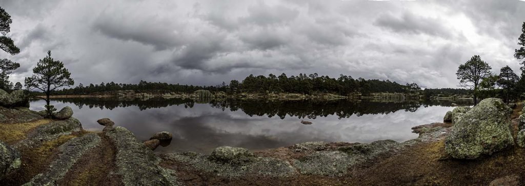
Lake Arareko is a very pretty ‘U’ shaped lake, all the more dramatic on a cloudy day.
Fantastic photos and wonderful information, eye-catching.
Thanks, appreciate your comments.