TIL: Middle Age Maps used South instead of North as the Primary Direction
Yup. There are even maps that had the primary cardinal direction as East or West.
But why the South as North?
Advances in civilization, writing, technology, and maps, was developed north of the equator in the northern hemisphere. That's where most of the advances in the last 3-4 thousands years has taken place. From Egypt, to Sumer, to Greece, to Rome, to China, to the Arabian enlightenment and the Renaissance enlightenment, it all came from the norther hemisphere.
What does this matter when talking about maps?
The sun is the life force, the life giver, the light, the truth, the high consciousness, etc. There is a lot of symbolism around the sun. The sun is extremely important for many cultures.
When the sun moves across the sky, what part of the sky is it in? Well if we don't have compass directions determined yet, this is when we create them, but not based on true north direcitons.
Where is the sun in the northern hemisphere? Well when you're above the Tropic of Cancer, looking at the sun at anytime, it's pointing in a certain hemispherical direction. That direction, is "north". All other compass directions relate to the north direction given. The sun gets up on one side, and sets on the other side, but all the while it doesn't cross over that imaginary zenith point to the northern hemisphere.
The sun is never above the zenith in the sky going towards the north. The sun from the northern hemisphere, for the most part, especailly above the Topic of Cancer, is below the zenith going towards the south.
This is why north was south through a symbolic belief reasoning with the sun's importance. It can also tie to "God", and "Holy Lands" being towards the south in some areas, or the east in others, or even the west for other cultures, and their maps were directed towards those "holy" belief centers. Like is the case with some Eruopean nations and Jerusalem orienting their maps Eastward. Until the compass was discovered, deciding where a compass pointed was arbitrary.
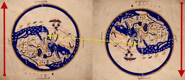
Here is an example, called the Al-Idrisi's World Map (1154).:

And here it is inverted, so you can see how it makes more sense as a recognized geographical area of Europe and the Middle East:

@krnel
2015-11-16, 10am
At least they knew the earth wasn't flat. :P
Yeah. The flat earth myth only started at the end of the Middle Ages in Medieval Europe before the Enlightenment.
http://www.sfu.ca/~swartz/flat_earth.htm
A myth that regularly comes back on steemit... ;)
Whoa! This is some cool info man. But I don't think it would have made a huge difference if we would have continued using the y- inverse maps, is it?
Yeah not really. If you want to say the metal part pointing one way is south instead of north, its ok. The meaning would have changed and north would have been the "southern hemisphere", etc.
Correct!
The map in the other way round makes it very hard to recognize... Thanks for sharing this interesting information I didn't know about :)
Welcome. The main interest I wanted to convey is the fact of belief directing us. A true magnetic direction existed as a foundation for an objective measurement on the planet for where we are in relation to another geographic location. But... since we like to believe in nonsense, various cultures decided what was important to them in their beliefs and made their direction based on that. The sun direction of where it is location for most of the year, and where it never goes, is at least based in the reality of the sun in the sky, but changes location relative to where you are on earth, i.e. north vs. south hemisphere. ;) People have attributed much emphasis on the sun in human history, tied in with religious beliefs.
And before the sun, it was the Earth... True :)