Drones for Remote Sensing Applications
What are the UAV applications?
There are 2 main words for applications which are RSTA and ISTAR. RSTA means reconnaissance, surveillance and target acquision. Generally, US military chooses RSTA. Additionally, ISTAR means intelligence, surveillance, target acquision and reconnaissance.
The picture below shows the various applications by UAVs. Many of them can be also accomplished by satellites but a VTOL UAV has many advantages.
Why Drones?
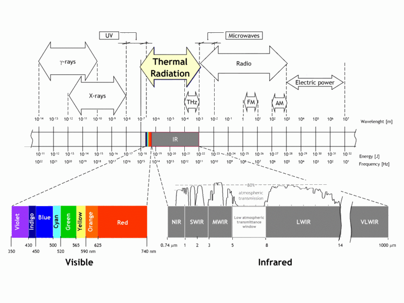
Look at the table. So, how can a drone be capable of all this? First, we need to understand what the electromagnetic spectrum is.
Electromagnetic Spectrum
Here is the NASA explanation; The electromagnetic (EM) spectrum is the range of all types of EM radiation. Radiation is energy that travels and spreads out as it goes – the visible light that comes from a lamp in your house and the radio waves that come from a radio station are two types of electromagnetic radiation. The other types of EM radiation that make up the electromagnetic spectrum are microwaves, infrared light, ultraviolet light, X-rays and gamma-rays.
How can we sense electromagnetic spectrum?
By active and passive sensors. Active sensors creates a signal in hardware and detects the response that is reflected from the Earth and processes the reflected signal to extract useful information. (LIDAR, SAR etc.)
Passive sensors do not create and radiate a signal to the Earth. Passive sensors detect reflected or radiated energy from natural sources like the sun. (Electro-optical (EO), Multispectral cameras etc.)
Examples for active sensors
LIDAR is the perfect choice for drones if you related to AI.
LIDAR (Light Detection and Ranging) sensor which directs a laser beam onto the surface of the Earth and measures the time of flight to the ground. The time of flight data is used to produce a three dimensional topographic map that accurately reflects the terrain and height variations.
SAR is really expensive for drones. Power consumption is quite high. This means inefficient power ratio and it causes the undesired flight time.
Synthetic Aperture Radar (SAR) is an example used on satellites, military aircraft, and UAV’s. It is a microwave imaging system that emits microwave pulses and post processes the reflected pulses to form images. SAR images can be produced through clouds, rain, and snow, day or night.
Examples for passive sensors
Multispectral Sensors is the best choice for the smart agriculture.
Multispectral sensor is sensitive across four independent spectral bands RGB and NIR. Post-processing software spectrally aligns the RGB and NIR imagery and stitches the aligned imagery into 2D RGB, NIR and NDVI mosaics.
Hyperspectral Sensors
Hyperspectral images can contain as many as 200 (or more) contiguous spectral bands. The numerous narrow bands of hyperspectral sensors provide a continuous spectral measurement across the entire electromagnetic spectrum.
Multispectral imagery can be used to map forested areas, while hyperspectral imagery can be used to map tree species within the forest.
Summary
Active Sensors -- its own source of light or illumination. In particular, it actively sends a wave and measures that backscatter reflected back to it. Light Detection and Ranging uses lasers to measure the elevation of features like forests, buildings and the bare earth. forestry, archaeology, land use mapping, flood modelling, transportation planning, architecture, oil and gas exploration, public safety, automated vehicles, military.
Passive Sensors -- Measure reflected sunlight emitted from the sun. When the sun shines, passive sensors measure this energy. Multispectral and hyperspectral enable us to understand the world. For example, we use it in the fields of agriculture, ecology, oil and gas, oceanography and atmospheric studies.
Active Sensors ------------------------------------------------------------------ Passive Sensors

Future Works
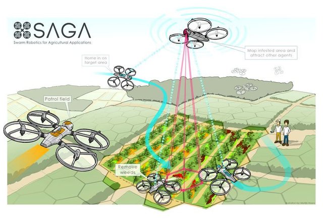
Swarm Robotics for Agricultural Applications
Swarm of drones programmed to monitor a field and precisely map the presence of weeds among the crops through on-board machine vision. Additionally, drones attract each other at weed infested areas, allowing them to only inspect those areas accurately.
References
o https://www.quora.com/What-are-the-pros-and-cons-of-satellite-imagery-versus-UAVs
o [PPT] Blyenburgh, P., “Civil RPAS: The European Approach”, Remotely-Piloted Aircraft Systems (RPAS): From Strategy to Action, AFCEA, Sintra, Portugal, 10/15/2013.
o [THESIS] Keane, J., F., “An Analysis of Multiple Sensor System Payloads for Unmanned Aerial Vehicles”, Naval Postgraduate School, Monterey, California, 09/1993
o [REPORT] House of Commons Defence Committee, “The Contribution of Unmanned Aerial Vehicles of ISTAR Capability”, London: The Stationary Office Limited, 07/15/2008.
o http://www.cropcopter.co/remote-sensing-101/
o http://articles.extension.org/pages/40073/what-is-the-difference-between-multispectral-and-hyperspectral-imagery
o http://gisgeography.com/passive-active-sensors-remote-sensing/
o http://gisgeography.com/lidar-light-detection-and-ranging/
o http://gisgeography.com/multispectral-vs-hyperspectral-imagery-explained/
o https://www.wur.nl/en/newsarticle/Will-precision-agriculture-bring-you-food-grown-by-drones-using-swarm-intelligence-.htm


