Sundarban,Bangladesh
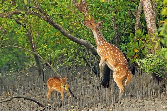
Sundarbans is a vast forest in the coastal region of the Bay of Bengal which is one of the natural wonders of the world. Located in the delta region of the river Ganges, Meghna and Brahmaputra, Khulna, Satkhira, Bagerhat, Patuakhali and Barguna districts and two districts of the state of West Bengal spread across North 24 Parganas and South 24 Parganas. The Sundarbans is the largest forested forest in the world as the largest mangrove forest in the coastal environment. [2] The Sundarbans, which are spread over 10,000 sq km, are 6017 sq km [3] in Bangladesh [4] and the rest is in India. Sundarbans was recognized as UNESCO World Heritage Site in 1997. The Bangladesh and Indian part of it is in fact the adjacent part of the same uninterrupted land, but the list of UNESCO World Heritage List has been indexed in different names; In the name of "Sundarbans" and "Sundarban National Park" respectively. The Sundarbans are trapped in the net, with small streams of marine streams, mud shores and mangrove forests, small-scale archipelago. 31.1 percent of the total forest area, which is 1,874 sq km, is riverine, inlet and bills, and is a watery area. [3] Forests, well-known Royal Bengal tiger, besides many species of birds, Chitra deer, crocodiles and snakes are also known as habitats . According to the survey, 500 tigers and 30,000 chitra deer are now in the Sunderban area. On 21 May 1992, the Sundarbans were recognized as the place of Ramsar
Naming
Sundarbans literally means beautiful forest or beautiful woodland in Bengal. The Sundarbans may have been named after Sundarbans, which grow in abundance there. Other possible explanations may be that it may have been named "Sea Forest" or "Chandra-Bandhede (Dam)" (Old Indigenous). But it is generally assumed that Sundarbans have been named from the beautiful trees. [2]
History
Hunger in search of hunting in the Sundarbans royal Bengal Tiger
In the Mughal period (1203-1538) a local king took the lease of the Sundarbans. Those fundamental changes that have been made in historical legal changes include being recognized as the world's first mangrove forest and under science-based supervision. The map of the Sundarbans area was prepared in 1757 after getting the rights from the Mughal Emperor Alamgir by the East India Company. The forest area is under organizational management since the establishment of forest department in India's then Bengal province in 1860 AD.
At the beginning of the eighteenth century, the size of the Sundarbans was nearly twice the present. Human pressure on the forest gradually shrunk its area. In 1828 the British government acquired the title of Sundarbans. L. T. Hajiz conducted the first survey of Sundarbans in 1829. In 1878 the entire Sundarbans area was declared as reserve forest and in 1879, the responsibilities of the entire Sundarbans were entrusted to forest department. The name of the first divisional forest officer of the Sundarbans is M. U. Green In 1884 he served as the Divisional Forest Officer of the Sundarbans. During the partition of India in 1947, 6,017 sq km of the Sundarbans fell into Bangladesh. Which is around 4.2% of Bangladesh's area and about 44% of the entire forest area.
The legal rights of the first forest management department were established on Sundarbans in 1869. According to Forest Act (Section 8) of 1965, a large part of the Sundarbans was declared as reserved forest in 1875-76. Within the next year, the remaining part is also recognized for the reserve forest. As a result, it goes away from the authority of the remote civil administration. Later, in 1879, forest department was established as the administrative unit for forest management, with its headquarters in Khulna. For the Sundarbans, during the 1893-98 period, the first forest management plan was enacted [5] [6].
The breath-taking fairs in the watershed of the Sundarbans
In the year 1911, the Sundarbans were termed as tract am waste land, which was never surveyed and no time has come under the census. Then the boundary of the Hooghly river is approximately 165 miles (266 km) across the estuary of the Meghna river. At the same time, it has set the inter boundary between these twenty-three Parganas, Khulna and Bakerganj districts. The total area of the reservoir, including the reservoir, is estimated at 6,526 square miles (16,902 km). Watery beautiful forests are full of tigers and other wild animals. As a result, attempts to survey could not be very successful. The name Sundarbans has been named probably by its name as Sundari (Heritiera fomes). The hardwoods found from this are used to make various items including boats, furniture. The Sundarbans are divided into rivers, canals, and inlet all over, some of which are used for the movement of both steamers and local boats, for communication between Calcutta and Brahmaputra Basin.
Geographic structure
Map of Sundarbans
In the film taken from the satellite, forest reserve areas are visible. Sunderbans is seen in dark green color, which is surrounded by light green agricultural land, copper painted cities and rivers are blue.
As one of the three largest mangrove forests in the whole world, the Sundarbans ecosystem located in the Ganges basin is just as complex as possible. The larger part of the Sundarbans (2 6%) of the two neighboring countries, Bangladesh and India, is located on the south-west side of Bangladesh. Duck