Venezuelan Geological Structures/Estructuras Geológicas Venezolanas
The geological structures determine the development of the earth's relief, an example of which can be seen in the topographic forms, which are presented as manifestations of them in a certain area, where the rock masses have some characteristics or aspects that constitute a structure.
The subject is broad, therefore I will mention some of them.
OUTCROP: Place where it appears to the surface a terrestrial of rock mass or mineral layer consolidated in the subsoil.
FORMATION: It is a formal lithostratigraphic unit that defines rock bodies characterized by common lithological properties (composition and structure) that differentiate them from adjacent ones. It is the main lithostratigraphic division unit. They can be associated in larger units (groups), subdivided (members) or differentiate smaller significant units (layers).
FOLD: It is a deformation of rocks, usually sedimentary, in which horizontal elements, such as strata or planes of schistosity (in the case of metamorphic rocks), are curved forming elongated undulations and more or less parallel between yes.
TYPES OF ROCK:
PIGGY ROCKS: They are formed by the solidification of magma, a molten mineral mass that includes volatiles and dissolved gases.
METAMORPHIC ROCKS: Strictly metamorphic is any rock that has been produced by the evolution of another previous to be subjected to an environment very different from its formation, much hotter or colder, or at a very different pressure.
SEDIMENTARY ROCKS: The geological processes that operate on the earth's surface cause changes in the topographic relief that are imperceptible when studied on a human scale, but that reach considerable magnitudes when considering periods of tens of thousands or millions of years. Thus, for example, the relief of a mountain will inevitably disappear as a result of weathering and erosion of the rocks that surface.
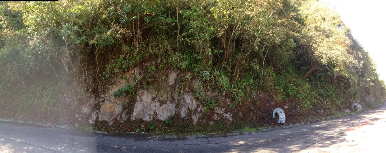
Failure and asymmetric or knee folding: To be able to observe the outcrop, the intervention of the man took place, when making the road, which showed that the strata of the road correspond to those of the outcrop, fulfilling the principle of lateral continuity. The misoa formation is part of a geomorphological complex called the misoa mountain range, which is the appendix of the Venezuelan Andes, the first elevations to reach the Andean mountain range.
Las estructuras geológicas determinan el desarrollo del relieve terrestre, ejemplo de ello se aprecia en las formas topográficas, las cuales se presentan como manifestaciones de las mismas en un área determinada, donde las masas de roca poseen algunas características o aspectos que constituyen una estructura.
El tema es amplio, por lo tanto haré mención de algunas de las mismas.
AFLORAMIENTO: Lugar donde asoma a la superficie un terrestre de masa rocosa o capa mineral consolidados en el subsuelo.
FORMACIÓN: Es una unidad litoestratigráfica formal que define cuerpos de rocas caracterizados por unas propiedades litológicas comunes (composición y estructura) que las diferencian de las adyacentes. Es la principal unidad de división litoestratigráfica. Pueden asociarse en unidades mayores (grupos), subdividirse (miembros) o diferenciarse unidades menores significativas (capas).
PLIEGUE: Es una deformación de las rocas, generalmente sedimentarias, en la que elementos de carácter horizontal, como los estratos o los planos de esquistosidad (en el caso de rocas metamórficas), quedan curvados formando ondulaciones alargadas y más o menos paralelas entre sí.
TIPOS DE ROCA:
ROCAS ÍGNEAS: Se forman gracias a la solidificación del magma, una masa mineral fundida que incluye volátiles y gases disueltos.
ROCAS METAMÓRFICAS: En sentido estricto es metamórfica cualquier roca que se ha producido por la evolución de otra anterior al quedar está sometida a un ambiente energéticamente muy distinto de su formación, mucho más caliente o más frío, o a una presión muy diferente.
ROCAS SEDIMENTARIAS: Los procesos geológicos que operan en la superficie terrestre originan cambios en el relieve topográfico que son imperceptibles cuando se estudian a escala humana, pero que alcanzan magnitudes considerables cuando se consideran períodos de decenas de miles o millones de años. Así, por ejemplo, el relieve de una montaña desaparecerá inevitablemente como consecuencia de la meteorización y la erosión de las rocas que afloran en superficie.
Falla y plegamiento asimétrico o de rodilla: Para poder observar el afloramiento ocurrió intervención del hombre, al hacer la carretera, lo que dejo al descubierto que los estratos de la carretera corresponden con los del afloramiento, cumpliéndose el principio de continuidad lateral. La formación misoa es parte de un complejo geomorfológico llamado serranía de misoa, que es el apéndice de los Andes venezolanos, las primeras elevaciones hasta llegar a la cordillera andina.
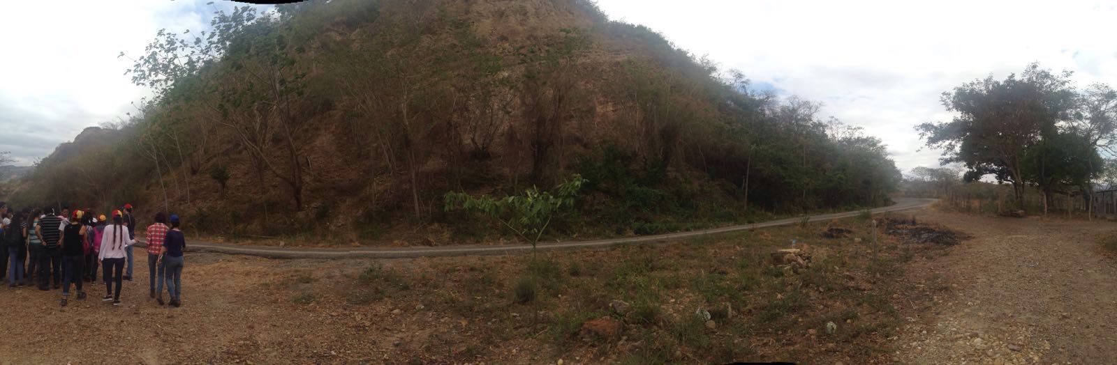
Misoa outcrop
DISCORDANCE: It is a geometric relationship between layers of sediment that represents a change in the conditions in which the deposition process occurred. In the absence of environmental changes or tectonic movements, the sediments are deposited in parallel layers. An unconformity is a stratigraphic discontinuity in which there is no parallelism between infra and overlying materials.
ANGULAR DISCORDANCE: when the rocks rest on an inclined formation.
LITHOGRAPHY DISORDER: when the layer of sedimentary rocks rests on igneous and metamorphic.
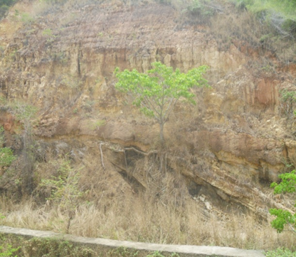
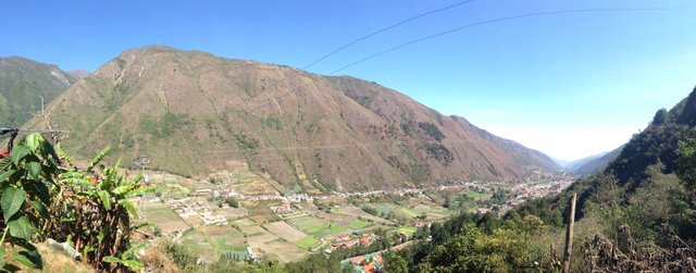
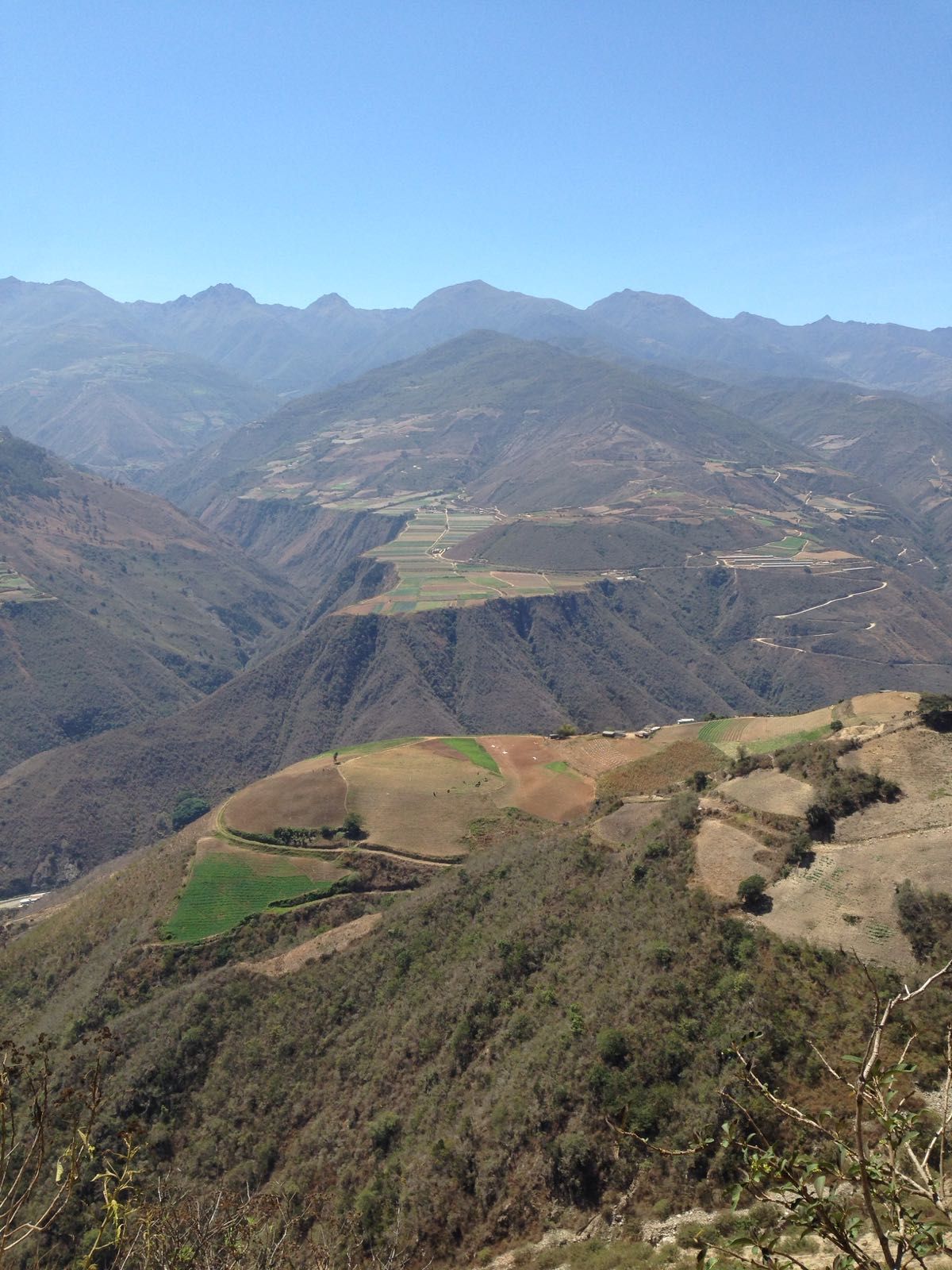
Geologically the unconformity shown below is between the Misoa formation (below) and the Isnotú formation (above), it is a disagreement of the Eocene, which is an important geological element along the Lake Maracaibo basin, since it is what defines one of the first pulsations that defines the formation of the Andean mountain range. When reaching the Eocene the plates began to collide and the first tectonic uplift began, which produced the deformation of the Misoa formation and those that were below it, then they eroded and this first discordant surface was formed, extending to throughout the entire basin. This happened throughout the Oligocene. Then the Isnotú formation is deposited, from the tertiary, specifically from the Miocene.
It is dominated by clays (65%), with numerous interspersed sandstones and subordinate layers of laminar clay, coal and conglomerate. The clays are massive but soft, of a light gray color, commonly variegated in red, purple and yellow and locally carbonaceous; The sandstones are of variable color, mainly white to light gray and are presented in layers of 2 to 3 meters thick.
DISCORDANCIA: Es una relación geométrica entre capas de sedimentos que representa un cambio en las condiciones en que se produjo su proceso de deposición. En ausencia de cambios ambientales o de movimientos tectónicos, los sedimentos se depositan en estratos (capas) paralelas. Una discordancia es una discontinuidad estratigráfica en la que no hay paralelismo entre los materiales infra y suprayacentes.
DISCORDANCIA ANGULAR: cuando las rocas descansan sobre una formación inclinada.
DISCORDANCIA LITOÓGICA: cuando la capa de rocas sedimentarias descansa sobre ígneas y metamórficas.
Geológicamente la discordancia que se muestra a continuación se encuentra entre la formación Misoa (por debajo) y la formación Isnotú (por encima), es una discordancia del eoceno, que es un elemento geológico importante a lo largo de la cuenca del Lago de Maracaibo, ya que es la que define una de las primeras pulsaciones que define la formación de la cordillera andina. Al llegar al eoceno las placas empezaron a chocar y comienza el primer levantamiento tectónico, lo cual produce la deformación de la formación Misoa y las que estaban por debajo de esta, luego ellas se erosionan y se forma esta primera superficie discordante, que se extiende a lo largo de toda la cuenca. Esto ocurrió durante todo el oligoceno. Luego se deposita la formación Isnotú, del terciario, específicamente del mioceno.
En ella predominan las arcillas (65%), con numerosas areniscas intercaladas y capas subordinadas de arcilla laminar, carbón y conglomerado. Las arcillas son macizas pero blandas, de color gris claro, corrientemente abigarradas en rojo, púrpura y amarillo y localmente carbonáceas; las areniscas son de color variable, principalmente blancas a gris claro y se presentan en capas de 2 a 3 metros de espesor.
Misoa mountain outcrop(angular discordance)
Ardent Water Formation: This, constituted by clastic sedimentary rock, shows the sunken block belonging to the San Lázaro Graben, which limits the Mucuchachi formation. There is an alternation of sandstones, shales, limestones showing glauconite weathering.
In this outcrop there is an intraformational failure, which affects only part of the formation; It also finds the failure of Red Tree, in addition to the presence of folds (pleats anticline and syncline). In this zone the Apón, Peñas Altas and Mucuchachi formation is present.
Formación Agua Ardiente: Esta, constituida por roca sedimentaria clástica se aprecia el bloque hundido perteneciente al Graben de San Lázaro el cual limita la formación Mucuchachi. Se encuentra una alternancia de areniscas, lutitas, calizas presentando meteorización de glauconita.
En este afloramiento se observa una falla intraformacional, que afecta solo a una parte de la formación; también encuentra la falla de Árbol Redondo, además de la presencia de pliegues (pliegues de forma anticlinal y sinclinal). En esta zona se encuentra presente la formación Apón, Peñas Altas y Mucuchachi.
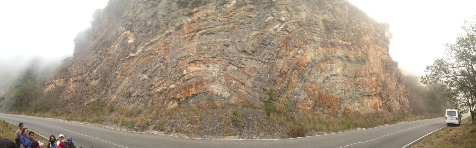
Outcrop of the Ardent Water formation
Formation the Towers: This outcrop, presents rocks that were sedimentary and entered a metamorphic phase but not completely, in this case we are in the presence of meta-sedimentary rocks.
Meta-sedimentary rocks are those that have been subjected to pressure and temperature which has changed and altered the texture in some way but has not metamorphosed them completely, keeping many characteristics of the original rock. The first thing that eliminated the metamorphism was the stratification, orientation in the direction of the efforts that produced the metamorphism, but not completely erase its texture, we have presence of brightness but if it had finished the metamorphism would have turned into a marble since it has presence of calcium carbonate which produces reaction to the hydrochloric acid, when calcium carbonate is present, it recrystallizes for this reason the marble is light, white or translucent. The metamorphism that affects this rock is regional, we usually attribute this type of metamorphism to a foliated rock but not in all cases this happens.
Any geological process that increases the pressure and temperature will produce a metamorphism but the final result of that metamorphism will always be a rock that depends on the original rock, that is, if a rock made up of grains is more likely to become a rock. foliated rock regardless of the type of metamorphism.
In this case we see a rock that, although it has not been completely transformed into a non-foliated rock product of the protolite (original rock) but through a regional type metamorphism with a non-foliated texture.
The formation of the towers is quite old, from the Upper Paleozoic, besides being a formation it is a type of stratigraphic unit, that is, this formation is associated to a type of sedimentary rock, however we see that it is metamorphic, in spite of being metamorphic we can call it a stratigraphic unit because it started being sedimentary and then metamorphosed.
Formación los Torres: Este afloramiento, presenta rocas que eran sedimentarias y entro en una fase de metamorfismo pero no por completo, en este caso nos encontramos en presencia de rocas meta-sedimentarias.
Las rocas meta- sedimentaria son aquellas que han sido sometidas a presión y temperatura el cual ha cambiado y alterado de alguna manera la textura pero no las ha metamorfoseado por completo, guardando muchas características de la roca original.Lo primero que eliminó el metamorfismo fue la estratificación, oriento en sentido de los esfuerzos que produjeron el metamorfismo, pero no borro por completo su textura, tenemos presencia de brillo pero si se hubiese terminado el metamorfismo se hubiese convertido en un mármol ya que tiene presencia de carbonato de calcio lo que produce reacción al ácido clorhídrico, al presentar carbonato de calcio este se recristaliza por tal motivo el mármol es de color claro, blanco o translucido. El metamorfismo que afecta esta roca es regional, normalmente atribuimos este tipo de metamorfismo a una roca foliada pero no en todos los casos esto ocurre.
Cualquier proceso geológico que aumente la presión y temperatura va a producir un metamorfismo pero el resultado final de ese metamorfismo siempre será una roca que dependa de la roca original, es decir, si una roca constituida por granos lo más probable es que se transforme en una roca foliada independientemente del tipo de metamorfismo.
En este caso vemos una roca que aun cuando no se ha transformado completamente en una roca no foliada producto del protolito (roca original) pero a través de un metamorfismo de tipo regional con textura no foliada.
La formación los torres es bastante antigua, del paleozoico superior, además de ser una formación es un tipo de unidad estratigráfica, es decir, esta formación la asociamos a un tipo de roca sedimentaria, sin embargo vemos que es metamórfica, a pesar de ser metamórfica la podemos llamar unidad estratigráfica porque ella comenzó siendo sedimentaria y luego se metamorfiso.
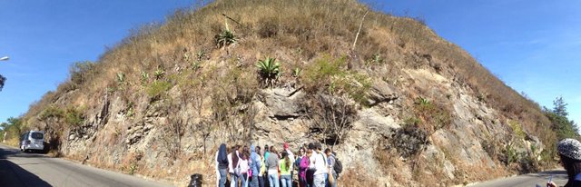
Outcrop formation the Towers
Granite Valera-La Puerta: first was the Mucuchachi formation and the formation was placed on the towers and below Mucuchachi was the Valera granite door. It is a batholith that formed very deep in the bark, and its name is due to that it goes from Valera, passing through La Puerta and extends to Timotes. The other part of the batholith is still in the subsoil. It is composed of plutonic acid-intermediate rocks (granite and granodiorite).
Granito Valera-La Puerta: primero fue la formación Mucuchachi y sobre ella se depositó la formación los torres y por debajo de Mucuchachi estaba el granito Valera la puerta. Es un batolito que se formó muy profundo en la corteza, y su nombre se debe a que va desde Valera, pasando por La Puerta y se extiende hasta Timotes. La otra parte del batolito se encuentra aún en el subsuelo. Se compone de rocas plutónicas acidas-intermedias (granito y granodiorita).
Granite Valera-La Puerta
Geomorphological features: Is a valley with a certain inclination and completely aligned between both hills, that is, between the middle of that aligned valley represents a chaotic area due to a fault located in the center of the valley called the river fault momboy
Geologically the city of Valera sits on fluvial terraces they are developed on Paleozoic rocks of the Momboy River Association and Granite Valera - La Puerta. Structurally the city is bordered by two faults of course known as Motatán and Momboy which deeply influence the neotectonismo of the area.
Características geomorfológicas: Es un valle con cierta inclinación y completamente alineado entre ambos cerros, es decir, que entre el medio de ese valle alineado representa una zona caótica debido de a una falla ubicada en todo el centro del valle llamada la falla de rio momboy.
Geológicamente la ciudad de Valera se asienta sobre terrazas fluviales las mismas se desarrollan sobre rocas paleozoicas de la Asociación Río Momboy y del Granito Valera – La Puerta. Estructuralmente la ciudad es bordeada por dos fallas de rumbo conocidas como Motatán y Momboy las cuales influyen profundamente en el neotectonismo de la zona.
View of La Puerta, where you can see river terraces
Risks are observed to a greater or lesser extent in the valley of the Puerta, flat areas that are river terraces that have the same level, above them are other flat areas. Principle of layer overlap. In the case of the terraces, they are not stratigraphic units but structures that occur as a result of the combination of the evolution of a river from tectonics.
Se observan riesgos en mayor o menor medida en el valle de la Puerta, zonas planas que son terrazas fluviales que tienen el mismo nivel, por encima de ellas se ven otras zonas planas. Principio de la superposición de estratos. En el caso de las terrazas no son unidades estratigráficas si no estructuras que se dan por producto de la combinación de la evolución de un río a partir de la tectónica.
River terraces
Morrena: Morrena is called to a mountain range that is near a glacier. It is also called moraine to the sediment settled by a glacier, since, in its route from considerable heights, the glacier drags the materials that are in its path. Some classifications of the moraines are: moraine of bottom, that is under the ice, on the bed; or lateral moraine, in which the debris is located on the banks of the glacier bed.
Next we observe a lateral glacial moraine located on the Granito Valera La Puerta formation. In addition to the lagoon that characterizes this zone, product of the deglaciation process and it is kept full by the exit of a spring, by abundant rains and humidity.
Morrena: Se llama morrena a una cordillera que se encuentra cerca de un Glaciar. También se denomina morrena al sedimento asentado por un glaciar, ya que, en su recorrido desde alturas considerables, el glaciar arrastra los materiales que se hallan en su trayecto. Algunas clasificaciones de las morrenas son: morrena de fondo, que se encuentra por debajo del hielo, sobre el lecho; o morrena lateral, en las cuales los derrubios se localizan en las orillas del lecho del glaciar.
A continuación observamos una morrena glacial lateral ubicada sobre la formación Granito Valera La Puerta. Además de la laguna que caracteriza esta zona, producto del proceso de desglaciación y se mantiene llena por la salida de un manantial, por abundantes lluvias y la humedad.
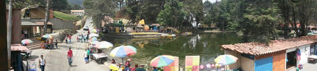
Lagoon and morrena in the background
I hope you enjoyed learning a little about geology and how to identify these structures.
Espero que les haya gustado aprender un poco sobre geología y cómo identificar estas estructuras.
Photographs taken by @betza
Fuente: Algunos conceptos de https://es.wikipedia.org/wiki/Discordancia_(geolog%C3%ADa)