NASA takes us on a trip to the Moon through an amazing 4K video of real and unique images of our natural satellite
A few months ago we are impressed with the awesome work of Seán Doran, who had created an incredible 100 megapixels photo of the Moon captured by the Lunar Reconnaissance Orbiter (LRO), the images US space probe intended for lunar exploration. Back then, we wondered why NASA did not have something similar or even more elaborate. Well, it seems that they finally heard our pleas.
The work of Seán was not perfect and was not scientifically supported. And now it's NASA's turn, who uses all their resources and knowledge to create the first tour of the Moon in 4K. It is a wonderful journey that allows us to explore important satellite sites while learning new details for the next manned mission.
The Moon as we have never seen it before
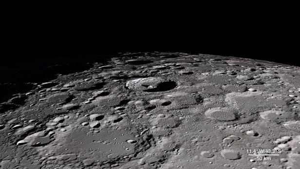
The LRO has been circling the Moon since 2009, in all this time it has managed to capture amazing details that have led to discoveries that allow us to understand a little more about what is in our galactic neighbor. Thanks to these images, it has been possible to know and study the evolution and structure of the Moon.
It is curious that NASA had planned that the LRO mission had a duration of one year and is already reaching the ninth. For this reason, NASA has compiled a large part of its images to create a great virtual tour of more than half a dozen key sites at a glorious 4K resolution. For those who want to know more details of each site, NASA has published on Tumblr information that serves to deepen their geology, morphology, and meaning.
Among the information found in the video, we can highlight the possibility of knowing the elevation and mineralogical mapping of some craters, which allows to better understand their age and other characteristics. Here it should be noted that after the presidential mandate to return to the Moon, the LRO has focused on locating possible sites for a lunar base and manned missions.
This is how they explain possible landing sites, such as the peaks of the mountains or the edges of the crater in the North Pole, as well as places where solar panels can be placed since scientists have been able to analyze the regions where there is more sunlight.
'Aristarchus Plateau' is one of those possible landing sites to mount a base, which is an old volcanic seedbed with a large and bright crater, which makes it visible to the naked eye. In fact, the infrared images of the LRO show the existence of silicate minerals, pyroxene, and plagioclase, which could be useful for the mission.
The data collected by the LRO is not only useful for future missions, it also allows us to know more about the old Apollo missions, where we can even see landing sites, such as the Taurus-Littrow Valley where the Apollo 17 arrived.
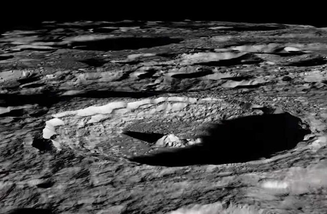
But the most impressive thing that we can see is the Aitken basin of the South Pole, with its more than 2,500 kilometers wide. As well as the Tycho crater and its mysterious central peak, which is estimated to be more than 100 million years old and whose origin is unknown despite having amazing images in high resolution.