Beautiful Satellite Images of our Planet you won’t believe are real #2
In my job at the European Space Agency we look at what satellite applications can do for non-space sectors of society. Sometimes, however, you simply have to stop what you do and enjoy the majestic beauty of some of the images we get!
I have long believed that our space instruments - Earth Observation Satellites or the Hubble Space Telescope - deserve an award for the artistic beauty of their images. Here are 3 of my favourites from recent months together with a short description of what you are seeing.
I hope you will enjoy!
Ouarkziz crater, Algeria and Western Sahara
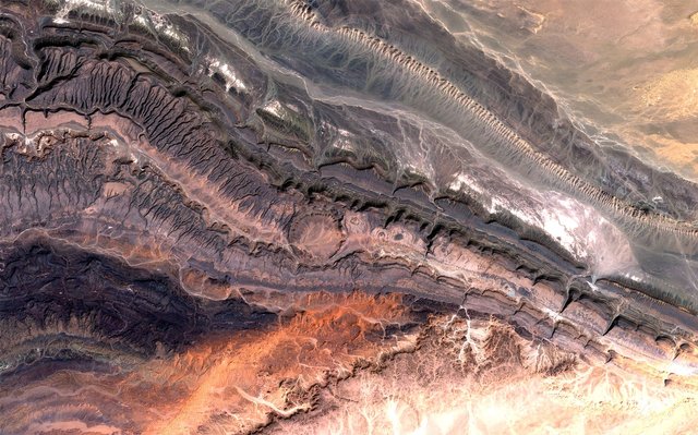
Image of the Ouarkziz crater and parts of the Anti-Atlas mountains bordering the Sahara Desert
This spectacular image covers part of the Anti-Atlas range in western Algeria. It was born from nothing less than a continental collision some 300 million years ago. Geologists believe it was once taller than the Himalayas but that its height was reduced over time through erosion.
Although the landscape here is mostly dry, as the mountains fall within the Saharan climate zone, some stream channels can still be seen. Some of these were created back when the climate was a lot wetter than today, while others stem from occasional water runoffs.
In the middle of the image, you can see the Ouarkziz crater as a big circle. The crater has a diameter of 3.5 kilometres and was created when a meteor hit Earth less than 70 million years ago when dinosaurs still roamed the planet.
Upsala Glacier, Argentina
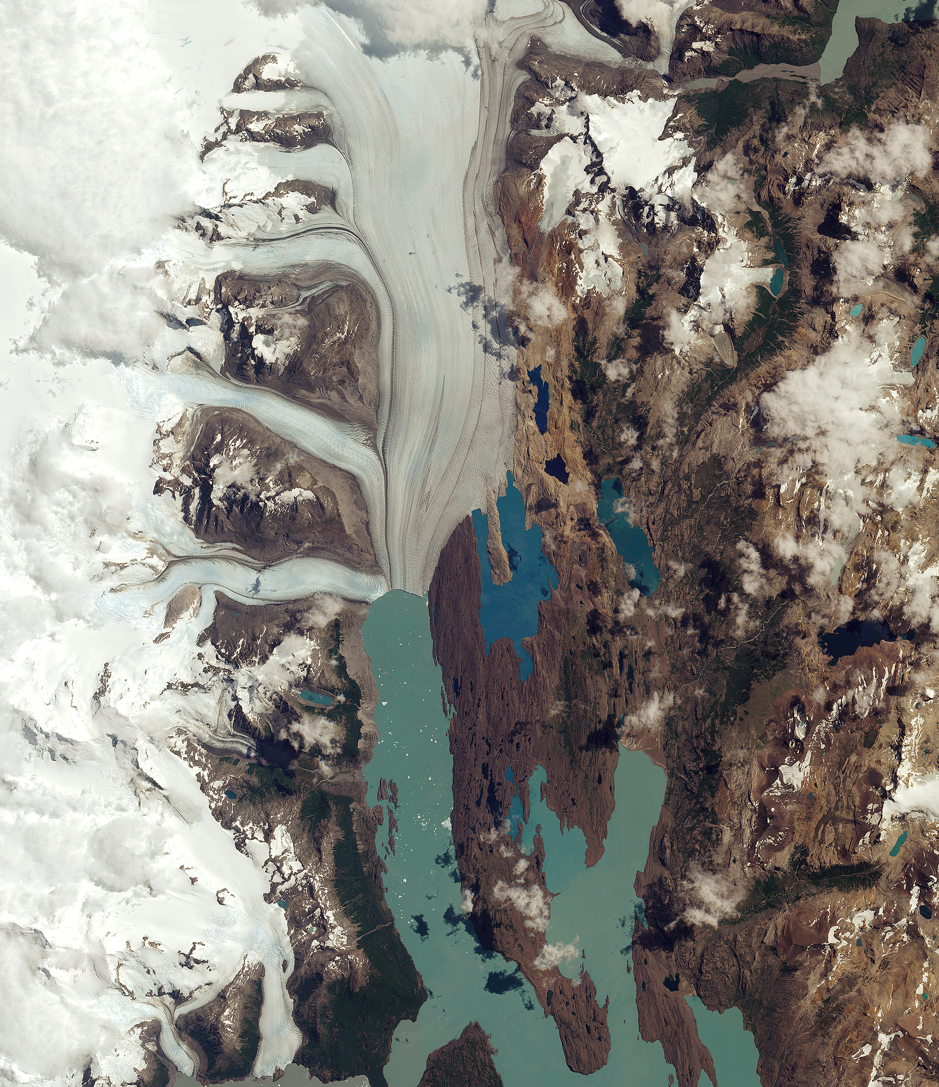
Image of the Upsala Glacier in the Santa Cruz province of Argentina
This image is of the Upsala Glacier in Argentina’s Los Glaciares National Park, which has been a UNESCO World Heritage site in 1981 and is the largest in the country, covering an area of over 7000 square kilometres.
These glaciers have been monitored closely by satellite images due to climate change. Indeed, many glaciers in the national park, and in the wider Patagonian Ice Field, have been retreating over the last 50 years due to rising temperatures. Over the past 15 years, the Upsala Glacier has retreated more than 3 kilometres.
Looking at the centre of the image, you can see small white dots across the lake. These are smaller parts of the glacier that has broken off and are now floating in the lake. The unique colour of the lake is due to “glacier milk”, which is suspended fine sediment produced by the abrasion of glaciers rubbing against rock over time. The darker lines following the flow of the glacier are moraines. These are accumulations of rock, soil and other debris, including glacial milk, that have been deposited by the glacier.
Uintah Basin, United States

Image of the Uintah Basin in Utah, US
This gorgeous image is taken of the Uintah Basin in northern Utah. The image is characterised mostly by barren land interrupted only by red, representing farmland, and rivers cutting through the landscape. The agriculture fields are seen as red due to the false colour processing applied to the image to detect vegetation in an otherwise dry and mountainous landscape. This showcases one of the many use-cases of Multispectral Instruments, as the stark contrast to the less-vegetated areas across the semi-arid region makes it easy to detect and monitor the state of vegetation.
In between the many agriculture fields on the upper left part of the image lies the city of Vernal. Because pavement and rooftops reflect no near-infrared energy (or at least very little compared to healthy vegetation) these urban areas will appear blue and white in an image like this. The long, light-brown rectangle shows the location of the regional airport.
On the top-right portion of the image, you can see parts of the Dinosaur National Monument. The park is home to hundreds of dinosaur fossils as well as scenic canyons that have been cut by winding rivers.
In the centre left of the image is the Uintah Basin, used for oil and natural gas production, seen as tinted blue. The extraction sites are scattered across the landscape as angular fields connected by numerous access roads. The large black and dark blue structures are evaporation ponds, likely used for wastewater from the oil and gas extraction activities.
Want to try processing new satellite images yourself?
All images above were taken by the European Sentinel 2 satellites. The image processing has been done by ESA, the European Space Agency. You can download the raw data from these yourself for free here, which can be processed professionally by the free tool snap. Or you may want to find and process images online here!
I hope to share more of these breathtaking images and continue making it a regular theme for my steemit blog. If there are parts of the world (perhaps where you live) you want to see an image of please let me know and I’ll dig it up!
Thank you for reading this far! My next posts will likely cover:
- “My conversations with 25 Astronauts, what it taught me about life, our planet, and much more”
- “A day working at the European Space Agency, suesas-sciencechallenge!"
- “Incredible things we can now do with satellites! #2”
So Follow me and stay tuned for more!
@fredrikaa, you always have the most interesting science content to share here in Steemit! Really enjoying your posts, looking forward to reading more of your contributions.
It amazes me to see how nature resorts to the same patterns and forms in both macroscopic and microscopic scale. Take the image of the Uintah Basin, for example: the fractal ramifications of what I suppose are rivers running through the land, closely resemble those of ice crystals (frost) on the surface of a humid window during frigid winter mornings.
Thank you @irime for a very kind comment. It means a lot to me, really. :)
Indeed it is fascinating. One of my main inspirers from when I got interested in science, Richard Feynman, used to say that he thought "nature's imagination is much greater than man's that it is never going to let us relax". And I believe that to be absolutely true. Nature does indeed come up with shapes, forms, colours and beauty that are beyond imagination (mine at least :) ).
Thank you for following and taking the time to read and comment!
Fredrik
Love your science life Fredrik, always interesting to jump into your posts. Great work, dufferent stuff from you as always, keep it up 👍
Thank you for the very kind comment @hqmafa420 ! Much appreciated.
Those could be confused with real pieces of art :)
Maybe I should run a competition where I randomly mix satellite images and modern art, and then it will be up to the steemers to decide which ones are which :)
You may have given me an idea ;)
ayyyyy
This gem of a post was discovered by the OCD Team!
Reply to this comment if you accept, and are willing to let us share your gem of a post! By accepting this, you have a chance to receive extra rewards and one of your photos in this article may be used in our compilation post!
You can follow @ocd – learn more about the project and see other Gems! We strive for transparency.
Awesome :)
ayyy heck yeah. it will be in tomorrow's batch of nominations. congrats again buddy :)
Wow man wonderful pictures :)
Absolutely! I find them gorgeous :) many more to come!
Amazing! They look like paintings :)
Indeed they do! I even have a few on my wall :)
Wow, stunning views. Our earth sure does look magnificent from up there!
Indeed it does! One of the reasons why I am saving for a suborbital flight in 15-20 years from now :P I sure want to experience what the Astronauts call the overview-effect!
Although with more and more free and open satellite data you can pretty much get it into your living room. (Except you won't get to be weightless ^^ )
That's a very ambitious plan, although I'm sure you'll be looking at weekly trips if you get your hands on a nice cocktail of crypto's :-)
Wow thumbs up
Thanks! I find them amazing too :)
Great post
Awesome, sometimes I like to watch the HDEV feed on the ISS, and put on a bit of classical and just chillax :-)
Cg
I have my own playlists dedicated for Hubbles images, satellite images and ISS footage. Perhaps something to share in the future :)
haha, nice one :-) Yes we should share, although the only fixed one I listen to is below. I just like to find something slow and soothing, while I watch the world go by :-)
Cg
meep