When the Earth Expanded
Likely, you've come across the idea that the Earth is made of plates that interact with one another by internal forces moving them across aeons, and maybe even accepted it as so.
This, however, does not capture the true history of the Earth.
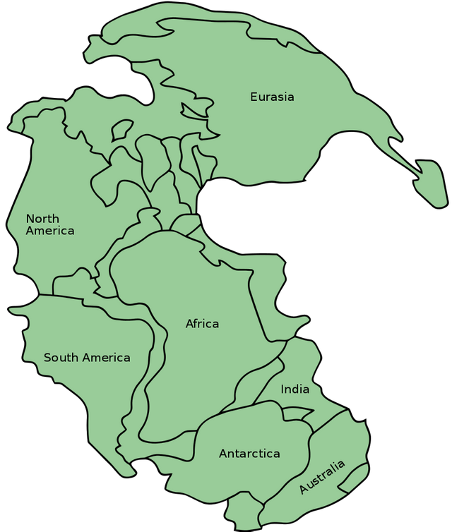
By analyzing the continents and the ocean floor, we have come to realize that the continents used to exist as a single landmass, known as Pangaea.

Map of Pangaea
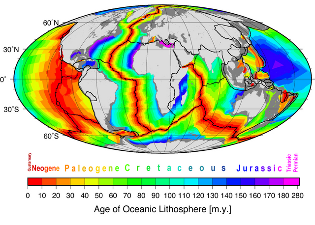
And between these continents, we have assumed that the ocean floor existed. Nevermind that evidence shows great amounts of time between the age of the continents and the age of the ocean floors...
With the oldest oceanic crust considered to be 280 million years of age, in order for the Earth to have remained the same diameter throughout its history it must have plates subducting under the continents and being erased from record.
But this is not Earth's history.
The Earth used to have a single landmass as its crust. It was smaller in radius, but was producing internal pressures that caused the crust to suddenly erupt in one location causing the crust of the planet to fracture. The precise process by which this occurred is not yet understood by science.
However, the Earth's rotation causes ethereal particles in the right proximal conditions to be moved into a flow to literally produce the Earth's magnetic field. These particles are locked in a gravitational orbit traveling in a Figure-8 manner and passing physically through the Earth and out the other side. The high relative concentration of the particles that results at the center of the planet then led to production of larger macroscopic particles that were trapped within the Earth, and heat.
This process was not instantly reflected in the whole Earth. Rather, internal pressure continued to build up.
and build up.
and build up.
and build up.
Until one day...
The Earth ruptured at it's south pole--of that time--where the internal pressure from the flow of the particles through the Earth put pressure on the external crust from the inside the most.
This process was not slow and steady. It was like a reaction. If a reaction does not have sufficient activation energy, it will not proceed. The Earth, too, required sufficient activation energy and then, upon its production, the crust ruptured and in a very rapid process the internal pressure was released.
Exactly how this all occurred is left for us to decipher through a sort of detective work.
For instance, most expanding Earth models accept the crustal age of the ocean floor. However, radioactive decay is a result of an imbalance between a system's internal pressure and external pressure where the system rapidly releases energy and enters into a new equilibrium. When particles were within the Earth, their ethereal environment was higher in pressure than when the particles exited the Earth. This change in their environment, as the particles cooled, led to rapid decay that occurred so drastically that the process, according to today's decay rates, appears to have taken millions of years.
Radiometric dating is not a valid tool for measuring absolute ages because it assumes a constant decay rate. Decay rates are known to be seasonally dependent and if the Earth were to itself undergo a process of decay then it would be expected to be accompanied by substantial amounts of decay. For instance, supernovae are known to be the simultaneous decay of all the atoms of a star.
In truth, it took months for the entire process to unfold.
This is evidenced by the Earth itself.
First we have to get a bearing on what was going on. In order to do this, we need to look to the evidence left behind.
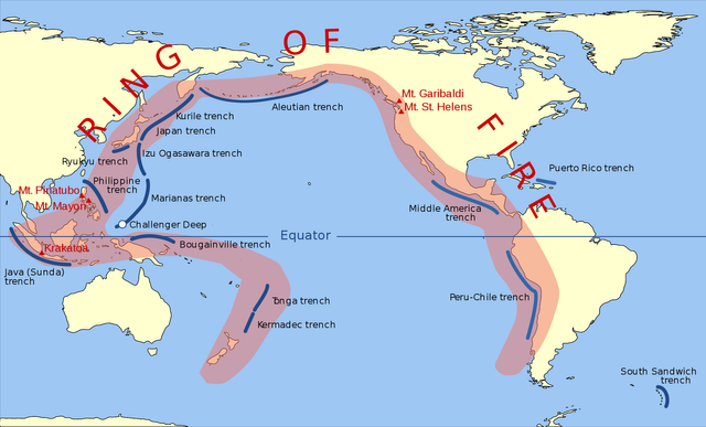
The Pacific Ocean is unlike other oceans of the Earth in that it is encompassed by the Ring of Fire.

The Pacific Ring of Fire
Second, as seen above, the oldest oceanic crust is in the western Pacific.
If we suppose that this generally hole-shaped region of oceanic floor was the first section created, as other continents began to sever from one another, then this is the distinct epicenter of where the Earth's crust critically failed from internal pressure.
Then, cracks ripped through the cold, hard outer shell of the Earth as its structural integrity failed from internal pressure.
As a result, contents of the Earth's internal pressure were released.
When the crust failed, it didn't just slowly begin spreading. The magnitude of this event was so profound that it makes everything we experience distinctly qualities of a period of equilibrium in comparison.
Water and magma gushed from the Earth. Heavier magma was unable to make it all the way up to the elevation of the continental shelf, but it still was released with such force that it penetrated into the land adjacent to the epicenter and shaped our world as we see it today.
The energy that was released into the landmass that would become South America shoved the continent in on itself with such force that it created the Andes:
The magma penetrated under the land and brought water with it, causing the area to be volcanic. Without water, it is only a mountain.
This also produced one of the largest trenches in the world.
And as the world ripped asunder, North America separating from South America, the western coast of South America was compressed and the mountain chain formed further and further into the continent as its overall width was smaller, until the point where there is no continent and the wave of energy coming from this part of the process is sent into the Caribbean to form islands in the newly formed ocean bed.
Meanwhile, the globe is rapidly pushing outward to a larger radius as its internal pressure stabilizes with its external pressure. This expansion happens first into the Pacific especially, and we see that the waves of energy that were sent into South America were physically reflecting off of the continent--while it still was attached to Africa to provide resistance, until the two fully fractured in the second stage of the process, as we see from the ocean floor age map. While not able to be relied on for absolute ages, relative ages are captured in the ocean floor age data.
This resistance though meant that the waves of energy and water being expelled from the gaping hole in the Earth were directed towards what would become Asia, more so than other regions. While the whole ring of fire is volcanic, not all regions were equally impacted by the Earth's expansion.
Waves of energy penetrated into Asia and, meeting sufficient resistance within the continent, reflected back and peeled continental shelf away from the main body into island arcs along the coast of Asia:
The reflection of the energy occurred along what is known as the North-South Gravity Lineament:
Not all energy went into the continent, though; some went along the coast of Asia. And accumulated into waves that traveled down the coast, further separating the fractured segment of continental shelf of Australia from Asia and accumulating material that produced what we now see of as the Indonesian Archipelago, and adjacent features:
As the arc of the Indonesian Archipelago built up material that produced resistance, the flows down the coast piled up into the rest of the islands of the region until the sea was enclosed by the Philippines. This led to the energy being reflected back into the Pacific Ocean which produced the Mariana Trench, leaving a stamped imprint of the motions as the energy rippled from the west to the east:
Meanwhile, water that was being released flooded out over Asia and met resistance as the weight and pressure of the water pushed up the Himalayas in an arc shape which illustrates the force in their formation was from the the northern direction rather than southern:
Where these two waves causing the Himalayas and the Indonesian Archipelago met, their collision caused the collapse of the Himalayan mountain chain in the eastern region where then, from the pressure of water in the Tibetan Plateau, the mountains were spewed out over the hillsides in the region:
With the whole mountain chain incorporated into the Himalayas, Mount Everest is even generally centered along the wave of the arc, where the most energy would have likely been experienced:
Water, with nowhere else yet to go, flooded the globe as the ocean floor was being created. After the first pulse of the initial, well, explosion of the Earth's crust, with the whole crust fractured sufficiently, subsequent releases of magma to the exterior were much more steady and allowed for the ocean floor to more evenly be produced, while the Pacific Ocean has no real explanation in Plate Tectonics--using the Atlantic Ocean as a starting point to then extrapolate the Pacific's mechanics. Indeed, plate tectonics does not even provide an explanation for the existence of the water itself.
The Earth's expansion, however, can explain all that we see on Earth's surface--if we seek explanation within it.
For instance, the disconnecting of South America from Antarctica was so energetic that a shockwave was produced as the continental tips recoiled from the detachment:
And then, one day, the process pretty much stopped. The system was then in a new equilibrium. As reactions are. They go from a phase of equilibrium through a transitional phase to a second phase of equilibrium.
Now, we look back at it all with radiometric dating and an aversion for flood explanations, not realizing that this is in fact what happened. Not millions of years ago but much more recently. Our society lived through this and mostly forgot. Although, it is written....


