You are viewing a single comment's thread from:
RE: If We Lived on a Sphere, Wouldn't Buildings Appear to Lean?
Cracks me up when people use a proof for flat earth when trying to convince people it's a sphere.
"Even the world record longest land to land photography image, at just over 300 miles (482 km), would only show an approximately 4 degree lean."
My question regarding this quote is: How do you think it's possible to see 300 miles away when your magic sphere should be hiding the image with 60,000 feet of curved water?
Just something for you to think about, try to come up with a good answer, I'm interested in your response.
Thanks for the laugh though. It was fun to read more ignorant assumptions about a group of people, when there's no backing other than guesses.
I am happy to answer that question.
Your statement that after 300 miles, the Earth should have curved 60,000 feet is based on the result you get from using the GitHub Earth Curve Calculator, or at least the same formula. (Other readers are advised to play with the calculator and see for themself).
Now, what you have to know is that this formula is just the math based on a perfect 2dimentional circle. As the site demonstrates with the image below:
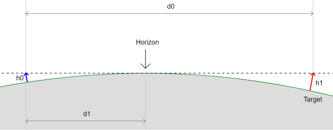
Height h0 and h1 are measures of the distance from a straight line and down to the circle. But for this to be applied to an experiment, you must make the assumption that the curvature is equal at all times. So basically assuming that the Earth is a perfect sphere. So yes, the fact that there is a point on Earth where one can take a 300mile photography does indeed disprove that the Earth is a perfect sphere!
However, nobody believes that it is. We've known for a long time that the Earth is very far from a perfect sphere (if this was to be literally true, the Earth's surface would be slick as a bowling ball). Instead, the model of the Earth that we have is one that is bulky and uneven. I mean, it would be amazing if even millions of years of titonic plates moving and colliding we would have been left with a complete perfect mathematical circle?
Below you can see the best model that we have according to our measures from the GOCE Satellite that we launched in 2009.
As you can see, the curvature is very different at different points of the Earth. This is why you can have some places on Earth that allow for longer distant photographs than others.
I doubt this will change your or Fulltimegeek's mind, but your question made the direct assumption that for the Earth to be round, one should necessarily see 60 000 feet curvature anywhere after 300 miles. This is simply not the model you're tasked to falsify. So I hope that at least it may have helped clarify what it is that the current model suggests is.
So there's the backing for his claim that one can be, and should be, able to find a place on Earth to take a longer distant photograph than others.
Steem on.
It's even simpler than that, too: https://en.wikipedia.org/wiki/Refractive_index
There are whole communities of photographers trying to get the longest shots possible, and they use this to their advantage, picking optimal locations, climates, time of day etc to maximize the refraction of light. This is where you find these 'record length' shots. They didn't just climb a mountain, they prepared hard for it.
And their observations always matches the models! I mean people should stop and ask themselves why, by chance, everything works when we use nautic miles and when photographers, like you say, use this model to find places to take photos.
Anyhow, my reply was just as much just trying to explain calmly why it is that we don't see the same rate of curvature that you get when you plug it into the calculators you find online.
Yes , refraction enables us to see the back of our heads while looking forward if on the highest point on earth, right? If not explain why not?
That model of the proposed appearance of Earth is very extreme. Where did Australia go? I would like some more info on what it represents. Highs and lows obviously but what are the figures. It is very drastic. Why do no other planets also have such characteristics?
I'm not a flat Earth believer but I also think that some that is presented as evidence for sphere Earth is questionable also. I'm not denying the satellite, or that the render in that image is factual. I just now think... WHY.. is Earth the only one that would be all lumpy and all the other planets not?
No it is not extreme, it just looks extreme because here you see the shape of the planet without water.
When you add it then it looks more spherical, but you still have the unevenness that accounts for why the earth does not curve 60000 feet after 300 miles, at every point on Earth.
That explanation raises more questions than answers. The deepest known point, The Mariana Trench is alleged to be 11 km deep. That model appears to indicate that it is a canyon on elevation. It then places a very massive indentation (by the deep blue indicator) on the opposite side of the continent of Asia.
In this video and by scientific calculations, the amount of water on Earth does not equal a very large mass. Leaving the Earth to still appear quite uniform and spherical in shape. (1:49)
I don't treat YT videos are science but Riddle at least tries to keep it factual. It's just hard to accept that the Earth would look like that without water. One then must believe that some areas of the ocean are close to or more than 100 kilometers deep.
only if one assumes that when the water is added, the result is a perfect circle (because yes, that would be the approximate level of water needed to return the height of the deeper valleys up to the level that kind of level).
However, we know the world is far from a perfect sphere, as is demonstrated both from our InSAR radar satellites and also ground-based observations showing differences in how far you can see on the ground.
So long story made short: When you add water to the image in the video I linked, it becomes less extreme, but still far from a perfect sphere.
In Riddler's video, there isn't near enough water to fill even a small area of those valleys. Thus in that Earth, the above sea level measurements would give some extreme readings in many regions of Earth.
Coincidentally, from the perspective of human, we would also see some bizarre anomalies in many regions. A rising horizon such as when one is at the foot of a mountain range would be a common sight. One would observe gigantic mountain ranges. From the perspective of Brazil facing towards Chile for instance.
I don't mean to discredit you nor the scientific community here. I'm merely questioning what logic determines as a clear discrepancy. Which evidently, is why the conspiracy of Flat Earth has grown in magnitude in recent years.
There ARE conflicting 'truths' within the science community and from reputable organizations, which in turn fuel speculation. Proclaimed images of Earth by NASA vs the now standardized version of a lumpy Earth alone would mean that one is a fallacy.
Flat earth people incorrectly apply the 8 in per mile formula. That formula is applied to the level line that is tangent to the observation point. Here is a utility that will show how much is hidden by the curve.
http://dizzib.github.io/earth/curve-calc/?d0=1429&h0=1314720&unit=imperial
No, that is the calculations he used. And he is right that the results you get does not match observations at every place on Earth. It is only right on average.
See explanation in my comment.
Earth is flat 🗺 nasa lie