HOW SAFE IS YOUR ENVIRONMENT?
Throughout the week I've been engaged in a series of GIS projects; Environmental Impact Assessment, Population Data Query, SQL dbase creation and Query and I'd like to share some of my findings.
How safe is your environment really?
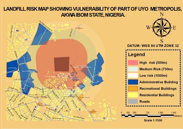
Okay the above image is a vulnerability risk map of a part of Uyo metropolis, interestingly, this map can be used to tell a lot of story about Public Health status, the quality of ground water within an approximate distance to the landfill, quality of air within the landfill surroundings, soil fertility effects, etc.
A landfill is a site for the disposal of waste materials by burial and the oldest form of waste treatment (although the burial part is modern; historically, refuse was just left in piles or thrown into pits), landfills have been the most common method of organized waste disposal and remain so in many places around the world, but then landfills have a distinctive effect on air pollution, nature, land and humans. Soil in the area may be saturated with chemicals or hazardous substances.
Hence, I carried out landfill mapping which is a crucial step in Environmental Impact assessment (EIA) to monitor land degradation and study its current and local impact on settlements and infrastructure within its environ and also produce a risk map to analysis vulnerability.
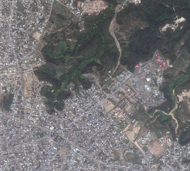
What is a Risk Map? In simple terms, risk maps help risk analysts and scientists to explore the spatial nature of the effects of environmental stressors. So off to the site, I coordinated the landfill extent(borders) using GPS which was also used for ground truthing and then I downloaded 2km by 2km digital satellite Imagery of the site, with these data, Ms excel and Arcgis, analysis was made easy.

Satellite image of the study area
This analysis which is an EIA ; is a procedure used to examine the environmental consequences or impacts, both beneficial and
adverse, of a proposed/existing development project and to ensure that these effects are taken into account in project design. Example of this also is the siting of telecommunication mast, heavy industries close to residential and commercial buildings, the former has great effect on health, due to UV radiations, From epidemiologic research, persons living in places where telecommunication masts are erected are vulnerable to disorders like cancer, lung diseases, sleep disturbances and even physical disabilities.

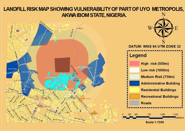
Map showing High Risk Buffer zone with about 790buildings
From the Risk Map above, buildings and Landforms within 500m buffer zones are vulnerable to high risk, features within 750m buffer zones are at medium risk and features with 1000m buffer zones are at low risk. Therefore the above data can be used by the state government for proper planning, mitigation and environmental monitoring
Funny enough, the State Government House is within the high risk buffer zone too lol.
Be conscious of your environment, your environment says a lot about your health.
Thanks much, if you had the time to share in my week. Would share more soon.
