The Superstorm of 1993: A Storm of Many Names
Growing up on the west coast of Florida has been one of the more memorable experiences in my life. Overall, the sixteen years I spent down there was time well-spent going to beaches, fishing and experiencing life as a kid. It wasn’t until I moved away, did I realize how unique of a place it truly was. Not necessarily because of the lifestyle involved, but because of the climate and weather. The interesting thing about growing up in the tropics is that bad storms were generally the stuff of legend. Whether it was that hurricane in November, a white squall while deep sea fishing or the water spout that hit a bridge, one thing is certain— intense weather is no stranger to Floridian's.
As a matter of fact, we enjoyed watching severe lightning storms from our front porch after a school or workday. Despite this fact, we would even be caught off guard by certain weather anomalies and that’s exactly what happened in the late winter of 1993. What we called the “No Name Storm,” would eventually be a storm of many names.
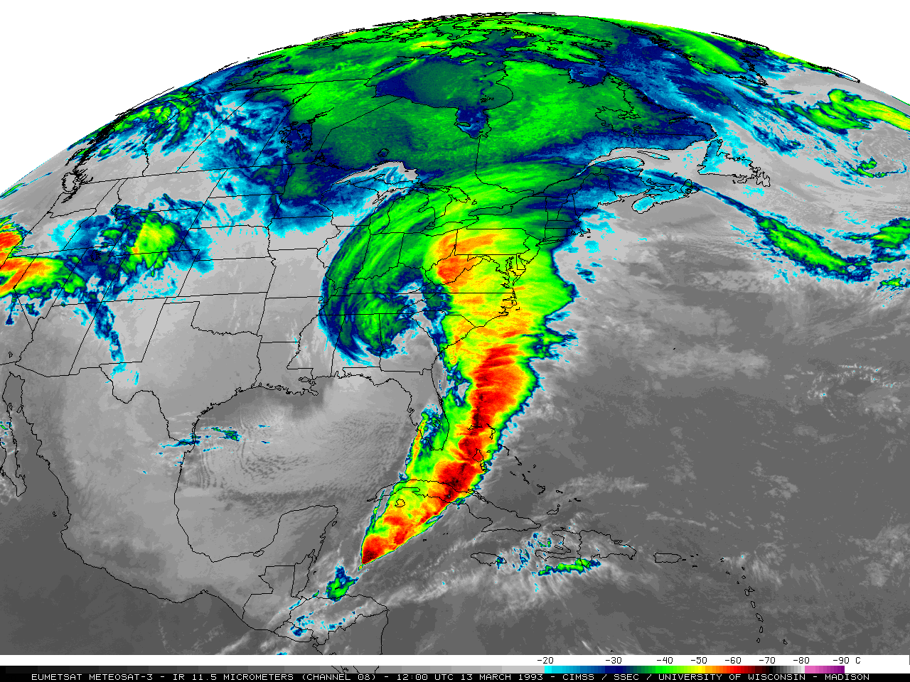 This infrared satellite imagery of the 1993 Storm of the Century displays how massive of a storm it truly was. A storm of this magnitude has not been recorded since. [Image Source]
In the early March of 1993, most of the eastern portion of the U.S. was thawing out from what appeared to be just an ordinary winter. During this time of year there’s typically a warming trend that tells us that spring is right around the corner. However, this year mother nature had other plans devised. In the far reaches of northern Canada and in the tropics of the Gulf of Mexico, two forces were gearing up to for a collision that would create a storm of legendary proportion. At it’s full strength, the cyclonic storm stretched from Honduras, all the way to Canada bringing hurricane force winds to the tropics and monumental blizzards from Georgia northward.
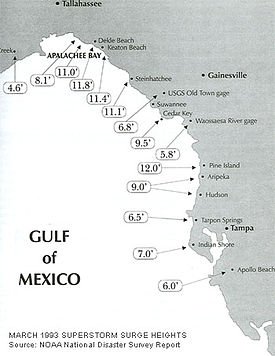
Depending on where you lived geographically, the storm was branded a different name— The No Name Storm, ’93 Superstorm, Storm of the Century, Blizzard of 1993—and with that came different experiences as well. In total, 26 states were effected, including the country of Cuba. It would impact over a 100 million people and cost billions of dollars in damages. Hurricane force winds were felt from Cuba (130 mph) to Florida (80-100 mph) and when there are high winds and coastline, there is a storm surge as well. On the west coast of Florida, up to a 12 foot storm surge was recorded.
In the Appalachian Mountains and mid-Atlantic states, up to 5 feet of snow was dumped on certain locations, leaving rural populations practically trapped due to most roads becoming impassable. In the region I eventually lived in western North Carolina (Smoky Mountains), locals told stories of snow drifts up to 35 feet and having to be air lifted by helicopter to safety. As for my memory of the storm, I honestly couldn’t tell you because I did the most Floridian thing ever— I slept straight through that monster. However, my father was able to tell me of his experiences. He spoke of a storm with green lightning, an epic storm surge and winds that nearly carried him way. Coastal properties were devastated and it left our community shocked. It should be noted, that this storm system occurred over the course of 24 hours, so it was as quick, as it was violent.
So what caused this superstorm? It developed from the collaboration of low pressures, high pressures and the fusing of jet streams all coming together at the right time. On March 12th, an extratropical area of low pressure began to develop off of the Texas Gulf Coast along a stationary front. As this occurred, an unusually strong arctic high pressure system for this time of year, was blasting its way south through the Midwest and Great Plains. To make matters worse, the subtropical jet stream began to push unusually far south as well, extending down to Honduras. This enhanced the cold front, extending it even further south as well.
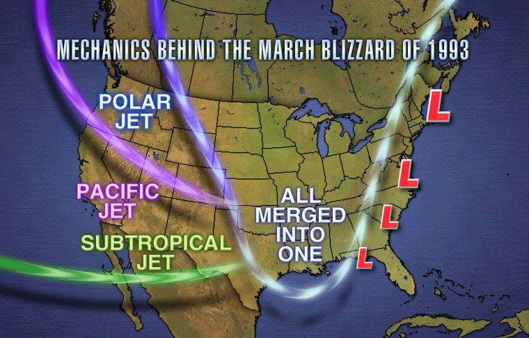
On March 13th, facilitated by a strong split-polar jet stream and a shortwave trough, the low pressure system on the gulf quickly deepened, which is an effect known as explosive cyclogenesis. Along the cold front, a squall line began to develop which moved rapidly across Florida and Cuba with hurricane force winds and tornadoes. When the cyclone made landfall in the panhandle of Florida, it was greeted by the cooler temperatures, allowing the perfect conditions for a whiteout blizzard to occur. Barometric pressure records for the month of March were broken from Tallahassee to New England, with readings as low as 960 millibars (28.35 inHh). To convey how low of a reading that is, most hurricanes have a barometric reading that is around 980 millibars.

Another thing that should be mentioned, is that weather forecasting during this era wasn’t considered to be very accurate. The 1993 Storm of the Century, was the first time in forecasting history that meteorologists were able to accurately predict the severity of a storm roughly 5 days in advance. While this most certainly helped populations prepare for the storm, most people were still caught off guard by the shear strength of it. Since then, forecasters have become more confident in computer forecast models, which is why today, it isn’t unusual for us to be notified of potential severe weather days in advance.
In meteorological terms, this storm was an extropical cyclone, nor’easter, blizzard, derecho and a tornado outbreak system, all combined into one. Additionally, the time of year in which it developed, made it a very odd occurrence as well. The power and history of this storm is absolutely amazing because it was a weather anomaly of epic proportion. In a way, it begs to ask the questions, how much do we actually know about our weather patterns here on Earth? Does this planet have any more surprises up its sleeve? Furthermore, did global warming play a role in its development?
If you enjoyed reading this post, be sure to give me a follow and check out the rest of my blog. Overall, my blog consists of scientific topics dealing with geology, meteorology, food and history. The goal of this blog isn’t to earn money per se. While that is a nice benefit, I’m more interested in networking, learning, informing and helping the Steemit community grow to new heights. Thanks for all your support!
Bibliography:
https://en.wikipedia.org/wiki/1993_Storm_of_the_Century
https://www.weather.gov/ilm/Superstorm93
https://en.wikipedia.org/wiki/Explosive_cyclogenesis
https://en.wikipedia.org/wiki/Derecho
https://en.wikipedia.org/wiki/Trough
https://sciencing.com/barometric-pressure-hurricanes-22734.html
This is very insightful @keephy! We've had storms in my country too and they're named in alphabetical order.
Typhoon Yolanda or Haiyan is the strongest storm that I've noticed in my country.
@originalworks
nice post plsce give me vote frineds
Oye muy buena investigación, excelente material. Con tu permiso lo voy a retwiterar
Great post! We will follow you closely for quality content!
Your Post Has Been Featured on @Resteemable!
Feature any Steemit post using resteemit.com!
How It Works:
1. Take Any Steemit URL
2. Erase
https://3. Type
reGet Featured Instantly – Featured Posts are voted every 2.4hrs
Join the Curation Team Here