World Surveillance - Orwellian Use of Satellites
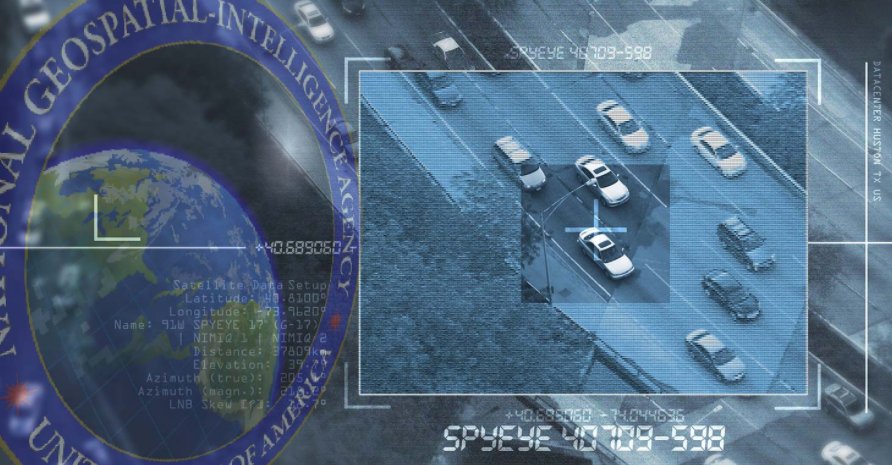
As a student in Geospatial Intelligence, it was no surprise to me that the entire globe is under effective surveillance using the most sophisticated methods and from the farthest reaches of Earth. The use of satellites for intelligence collection can not be understated. In fact, if it can fly, float, travel through space, or move along the ground, it is potentially a platform for intelligence collection. As such, aircraft, satellites, ships, submarines, and ground platforms all are used for collecting intelligence.
Remote sensing platforms can be used in intelligence for surveillance or reconnaissance. The difference between the two is the dwell time on the target area; surveillance is defined as continuous dwell, while reconnaissance is a dwell for a relatively short period of time, even a snapshot. Since low earth orbit satellites can see a given spot on earth for only a few minutes at a time, this platform can only be used for reconnaissance. It should be noted that aircraft, ships, submarines, and ground stations—can be used for either surveillance or reconnaissance.
Regardless, satellites provide the bulk of the remote sensing used today in intelligence. Why? One of the major advantages is that a reconnaissance satellite can legally overfly any country while obtaining intelligence information. An aircraft or unmanned aerial vehicle (UAV) cannot. Many countries have launched reconnaissance satellites since the first launches in 1960; Russia, China, the United States, France, Germany, Japan, India, and Israel all have reconnaissance satellites in orbit. The total number of launches over the years probably is in the hundreds. In addition, satellites have a lifetime of only a few years, and there have been a number of launch failures, especially in the early years.
Satellites used for intelligence purposes customarily are referred to in the United States as overhead collection assets. It is important to note that the path followed by a satellite is referred to as its orbit and as such, satellites are constrained to move in these defined orbits. Because of such limitations orbits are matched to the capability and objective of the sensors the satellites carry.
A low earth orbit (LEO) satellite orbits between 200 and 1,500 km above the earth's surface. Earth imaging satellites and some SIGINT satellites typically use this orbit, since closeness to the target is most important. Satellites in LEO circle the earth in about 90 minutes. A medium earth orbit (MEO) satellite typically orbits at 10,000 to 20,000 km above the earth. A major intelligence advantage of the MEO satellite is survivability: it is more difficult for opponents to locate and attack during wartime than LEO satellites, and the orbit provides better sensing capabilities than the GEO or HEO satellites can deliver. A highly elliptical orbit (HEO) satellite is placed in an orbit in such a way that it will spend the greatest amount of time over a specific area of the planet. A geostationary (GEOJ satellite orbits the earth in an equatorial orbit at an altitude of 35,800 km, where its rotational period is equal to that of the earth's rotation (24 hours).
Finally, a major hazard of the space environment is the combination of space debris, micrometeoroids, and dust that can damage or destroy a satellite. Space debris is an increasing threat as more satellites are placed in orbit along with launch-related debris. Space debris has become much more of a problem for LEO satellites in recent years, largely as a result of two events. On January 11, 2007, China conducted an anti-satellite weapons test that created a massive debris cloud at LEO altitudes. On February 10, 2009, a Russian satellite collided with the Iridium 33 commercial satellite, creating an even greater debris cloud.
As technology continues to develop practical methods for both peace and warfare applications, surveillance and reconnaissance will undoubtedly be at the forefront. The world is indeed reflective of Orwell's technocratic nightmare.
I cannot make an intelligent comment about your article. I do not know enough, but I will certainly do some more research. Your article "tickled" my innate search for information. Your final sentence regarding Orwell's technocratic nightmare, is scary, I must say.
Thanks for commenting. I would definitely suggest looking into the history of geospatial applications in intelligence if you are curious to see the historical trends. It has gotten to a point where technology has fueled the desire for more surveillance and policymakers now prefer SIGINT, MASINT or GEOINT over HUMINT intel, even at the immense costs.