Cool things we can now do with Satellites #4 : Monitoring Bark Beetle Infestation
In my current work with the European Space Agency, I work to help foster innovation around the use of satellite data. It is an exciting area that is seeing explosive growth with many new user applications being developed. Here's an example I've been involved with lately.
Monitoring the spread and impact of Bark Beetles
Most use cases for satellite imagery are to monitor larger objects, or environmental changes on a macro-scale, such as the world's oceans, atmospheric changes, large scale-deforestation, etc. So how can they possibly provide a use case for a tiny animal such as a bark beetle?!? Well, they might be small, but their impact can be huge, as can be seen on the image from an Alpine forest below
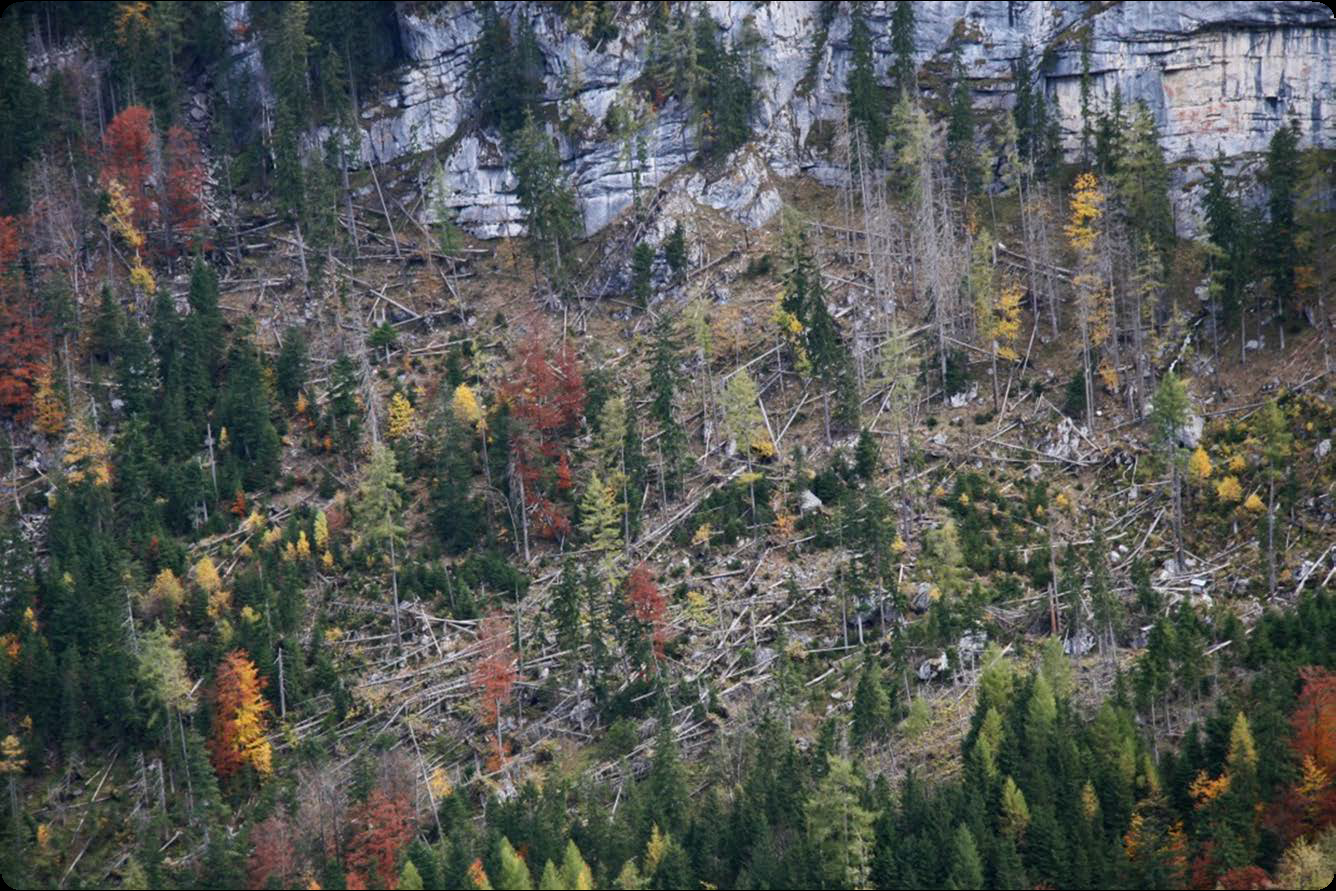
Impact of Bark Beetle Infestation in Berchtesgaden southern Germany
Image credit: Nationalpark Berchtesgaden (Geofachdaten), Bayerische Vermessungsverwaltung and SAGIS (Geobasisdaten)
Due to the potential destruction of forests, Natural parks and foresters alike are very cautious to monitor the trees for signs of bark beetles and to take quick action to prevent infestations in their regions. However, continuous monitoring can be very expensive, especially in Alpine regions where most of the trees are difficult to access by foot.
In the last couple of years, bark beetles have become an increasing issue in the Alps. This because the beetles have moved to higher altitude regions where they have historically never been seen before. Local researchers believe this to be a result of climate change, as lower parts of the Alps now see less snow and ground-frost, allowing the bark beetles to thrive in an environment where they would previously never be.
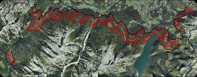
Alpine areas exposed to the threat of Bark Beetles in Berchtesgaden's Natural Park
Image credit: Nationalpark Berchtesgaden (Geofachdaten), Bayerische Vermessungsverwaltung and SAGIS (Geobasisdaten)
Since it is the duty of the park both to preserve the natural state of their forests, and also to ensure that the bark beetles won't spread to areas outside of the Park, they have worked closely to monitor them. To do so more efficiently, they began to make use of satellite imagery to monitor the state of the forests on a regular basis to detect early signals of an infestation.
Theoretically, this can be done in a number of ways, and researchers have previously looked at both combining optical imagery with radar data to more significantly predict patterns corresponding to early infestations, Ortiz, et. al 2013. In this case, the data they use are optical images provided for free by the European Sentinel 2 satellites. They then obtain new images of the woods every 5 days. Symptoms of a bark beetle infestation are then identified through detecting subtle changes in biophysical variables which can be reported to the people working at the Natural Park. A computer then gets better and better at detecting early patterns to autonomously detect and report signs of bark beetle infestation of trees.

The European Sentinel-2 satellite provides optical imaging from 13 different sensors capturing different parts of the electromagnetic spectrum
image source
The conclusion, so far, is that the satellite-based solution is ideal for a handful of reasons. They provide frequent and standardized revisit times. They are a lot cheaper than areal imagery (at least if you want to obtain new data as often). Their images can cover large areas such as the natural park. They can monitor mountainous and inaccessible regions just as easily as any other regions.
I thought it was a cool example mostly because it is an application I would have never thought about, but which clearly has a lot of impact on some communities around the world. So it is great to see use cases benefiting not only the large industries such as agriculture or oil and gas (which are the two largest users by industry) but also more remote and local users.
Want to try processing new satellite images yourself?
Today, huge amounts of data are made freely available through the Copernicus programme run by the European Commission and the European Space Agency. You can download the raw data from their satellite constellation yourself for free here, which can be processed professionally by the free and open source tool snap.
Did you find this information fascinating? Make sure to Follow me for more, and look also into my Beautiful Satellite Images of our Planet you won’t believe are real where part #3 will be online tomorrow!