Where Eagles Fly : Zapata Ranch ~ Underneath the Towering Sangre de Cristo Mountains in Colorado
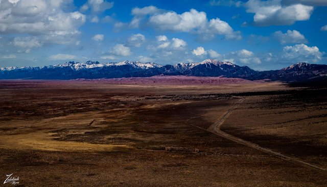
This lone road leads to the Great Sand Dunes National Forest and on the way passes through the Zapata Ranch. Owned by the Nature Conservancy, this 100,000 acre high desert ranch is home to thousands of Bison, Elk, Cattle and horses.To read about the ranch go here: http://www.zranch.org/
In the distance are the towering mountains of the Sangre de Cristo (Spanish for "Blood of Christ") the southernmost sub-range of the Rocky Mountains. This beautiful range runs all the way from Poncha Pass in South-Central Colorado, to the southeast and then due south, ending at the Glorieta Pass, just southeast of Santa Fe, New Mexico.
This impressive range used originally was known as "La Sierra Nevada", or "La Sierra Madre", or "La Sierra", and simply "The Snowies" (used by English speakers). It was not until the year 1719 that the Spanish explorer Antonio Valverde y Cosio named the range "Sangre de Cristo" ("Blood of Christ") mountains after being impressed by the reddish alpenglow hue of the snowy peaks during sunrise.
(Research Source)
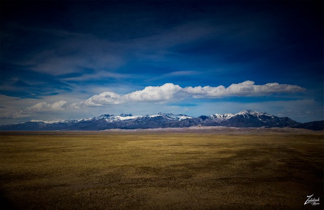
On the right side of this image is Mount Herald with its 13340 ft / 4066 m peak. Below this is the Great Sand Dunes National Park, containing the tallest sand dunes in North America. Rising to their maximum height of 750 feet / 229 m, above the high desert San Luis Valley floor these sit on the western base of the Sangre de Cristo Range. Covering an area of about 19,000 acres / 7,700 ha, researchers say that the dunes started forming less than 440,000 years ago and were created from sand and soil deposits of the Rio Grande and its tributaries, flowing through the San Luis Valley.
Over the ages, melting glaciers that fed the river and vast lake that existed across the valley melted away, and the water evaporated. This allowed the strong westerly winds to pick up the exposed remaining sand particles from the dry lake and river flood plain. Then, as the wind eventually lost power prior to crossing the Sangre de Cristo Range,all that sand was deposited on the eastern edge of the valley, creating the piled up dunes we see today. This process still continues, and the dunes are slowly growing. The wind changes the shape of the dunes daily as it continues to move sand from the middle of the valley northward.
(Research Source)
This image is from my project "Where Eagles Fly".
About The Project
Where Eagles Fly - The American Wilderness Expedition is my personal mission to introduce people to these amazing locations that surround us. I am piloting a bush plane while exploring and filming throughout the remote back-country areas of North America to raise awareness of the 47% of the USA and 90% of Canada that remain unpopulated wilderness.
About The Author
My name is Zedekiah Morse and I'm a Bush Pilot, Photographer, Explorerand Filmmaker. I live in the Rocky Mountains and devote my time and resources to exploring as much of the world as I can by air.
If you wish to watch a short film detailing how I do my work and this project, go here.
Thank you for your support and Yehaw!!
Very good photography. I like it your post
Today's pictures were beautiful. With your article is informative. It was good to read the article.
Nice photo @skypilot. The weather is sunny even though the land there is a bit arid. How are you, I have not spoken long. Hope you are healthy always and can produce extraordinary works.
Thanks~ I am well, I hope you are too. We are finally warming up here in the mountains so I am flying and filming a lot now.
Bello paisaje, me agrada tu post, aquí en esta red podemos a través de la comunidad conocer lugares muy lindos...gracias