Where Eagles Fly : White Cliffs of the Escalante Grand Staircase ~ An Amazing Landscape
Because my recent combination of 5 posts into 1 binge readable post got such good response from my fellow steemians, I have put together another bingable read which combines the 4 posts I made a couple weeks ago about the White Cliffs in the Escalante Grand Staircase. I hope you enjoy this as well.
While flying above the high desert to the east of Zion National Park while exploring the wilderness of the Escalante Grand Staircase I came upon this remote and beautiful location where Deer Springs Wash (the creek on the left) and Park Wash (the creek on the right) flow together and create the Kitchen Corral Wash (the creek on the bottom right). I have explored this place a number of times for my project Where Eagles Fly and have found a number of really interesting locations in this area I would like to share with you in this post.
Tiny Ranch in Kitchen Corral Wash
In this image I lensed while flying over Telegraph Flat you can see on the horizon the pink Hoodoo cliffs of Bryce Canyon National Park standing like eternal palisades, keeping watch over the ancient landscape below. Running horizontally across the middle of the image are the White Cliffsand located below them are the Vermilion Cliffs. The green brush plateau below the White Cliffs is called the Deer Range and the canyon on the right side of the range is called Box Elder Canyon.
All of these brightly colored formations are part of the Escalante Grand Staircase. This 275 million year old geologic formation begins on the north side of the Colorado River down in the bottom of the Grand Canyon National Park and moves north and west up to Bryce Canyon and west to Zion National Park.
 Kitchen Corral Wash ~ Click to Enlarge
 In the image above, on the right side of the image, along that narrow dirt road, there sits a really small ranch. This is a very remote location and from the way the ranch is designed it looks as though they do a lot of horseback riding.
I have passed over this a ranch number of times in my explorations and a couple of times I waved at the guy on horseback. One of these days I will probably land there and pay them a visit. I'd love to give them a print of this image! I think this is a very cool remote little getaway.
 Kitchen Corral Ranch in the Spring ~ Click to Enlarge
 This ranch sits at the bottom of a ridge called Kitchen Corral Point. This reddish purplish ridge is a prehistoric Mesozoic geologic formation known as the Moenave Formation. This area is loaded with dinosaur fossils!
 Kitchen Corral Ranch in the Winter ~ Click to Enlarge
 The following image is a panorama of the are with the tiny ranch in Kitchen Corral Point located in the bottom center of the image. You can clearly see the full length of Bryce Canyon National Park on the horizon and the entire length of this section of the White Cliffs along the middle of the image.
The protruding Monadnock on the right side is Mollies Nipple which rises up above Starlight Arch in the mysterious Starlight Canyon. And on the distant right side of this image lays Kodachrome Basin State Reserve, a geologic fairyland of monolithic stone spires, called sedimentary pipes, with accentuated multi-hued sandstone layers that reveal 180 million years of geologic time.
On of the really amazing facts about this image is that this little ranch is the only sign of habitation in this entire huge area covered in this image. I LOVE this location! What a serene place to be.
 Panorama ~ White Cliffs & Kitchen Corral Wash ~ Click to Enlarge
 Here is a link to google maps for the location of this beautiful place.
Ancient Anasazi Ruins
This area was the ancestral home to many Tribal Nations throughout time and this particular part of the Park Wash River was home to a the buried ruins of a small village that lay in the foreground of this picture, right along the riverbank.
This small river flows down from Bryce Canyon, whose pink Hoodoo cliff formations are visible along the distant horizon. These buried ruins along the river banks are a from a very old people known as the Ancient Anasazi, with is First Nations Diné for the; "Old Ones".
 Ancient Anasazi Village Site at Box Elder Canyon ~ Click to Enlarge
 In the very first image at the top of this post, if you enlarge the image and look closely along the lower middle of the image, next to the creek about a quarter of the way up, there is a tan-brown clearing with a small trail running alongside it. This is another site where ancient ruins were found, including multiple living dwellings, animal pens and storage houses, along with a number of burials.
In this area they have found many dwellings and artifacts that show this small valley was farmed and hunted in for many thousands of years. The small river running up through the image is called Park Wash. At the bottom of the image where the river branches off to the right at Box Elder Canyon, do you notice that small area of land between the two branches of the river? That is the location of one of the Ancient Anasazi Dwellings.
This was a beautiful area, full of resources and mysterious geological formations when helped shape the traditional beliefs of these original occupants of this sacred place. If you are interested in the archaeology related to this very location in these images, go here to read their report on the discoveries.
Infamous Outlaw Hideout
This post reveals little known facts about this area and in particular the historic association with a very well known, or rather, infamous outlaw from the wild west of the 1800's. There is a short film I made about it at the end of this post as well.
But first let’s take a look at this image below, First of all, the Pink Cliffs in the distance along the horizon are the Hoodoo Cliffs of Bryce Canyon National Park. The river that that runs vertically from the middle of the image to the bottom right actually carries the runoff water from the Pink Cliffs of Bryce Canyon, and because of its headwaters origin, this river is known as Park Wash.
The White Cliffs that run horizontally across the middle of this image and the Park Wash River that passes down through the cliffs are our focus for this post. The cliff on the right side of that long formation is named No Mans Mesa, the left side is called Deer Sprint Point and the middle is called Calf Pasture Point.
 White Cliffs and Park River Wash ~ Click to Enlarge
An interesting historical fact about these White Cliffs is their association as a hideout for an outlaw from the wild west era by the name of Robert Leroy Parker, but better known to popular culture as Butch Cassidy of the Butch Cassidy and the Sundance Kid fame. Their gang was known as the Wild Bunch.
 The Wild Bunch ~ Sundance Kid on the Left & Butch Cassidy on the Right
Butch grew up in Circleville, Utah, about 30 miles or so to the east of this location. And he know this place like the back of his hand as he had worked as a cowboy around the area all through his youth. When he turned to crime and began a career as a cattle rustler (he was a teenager at this point) he would use this area to hide from the various posse's and lawmen hunting him. After he grew into a full-fledged outlaw, he joined forces with Harry Alonzo Longabaugh a.k.a. the Sundance Kid and formed one of the most infamous outlaw gangs in the wild west; The Wild Bunch.
The Wild Bunch Gang had a couple of interesting facts that they were known for at the time; they claimed to make every attempt to abstain from killing people, and Cassidy boasted of having never killed a single man or woman in his entire career. And the gang was closely associated with female outlaws Ann Bassett and Josie Bassett, whose ranch near Browns Park supplied the gang often with fresh horses and beef.
Both Bassett girls would become romantically involved with several members of the gang, and both would occasionally accompany the gang to another of their remote hideouts, called "Robbers Roost", which was only a few miles from this one.
Another thing that was rather unusual was that they were well liked by the public in this area. Associations with local ranchers allowed the gang considerable mobility, giving them an easy resupply of fresh horses and supplies, and a place to hole up for a night or two.
(Research Source)
In the images up top,you can clearly see how the Park Wash River passes into the White Cliffs. And on horseback, on the ground as you approached the White Cliffs it looks as though there is no pass through the cliffs.
If you follow the river up into the cliffs where it passes through a narrow opening in the cliff walls. This is called "Hole in the Wall". This was the first place Butch used for such escapades but it was perfected later when he joined forces with Harry Alonzo Longabaugh a.k.a. the Sundance Kid and formed one of the most infamous outlaw gangs in the wild west. They then created another infamous hideout also called the Hole in the Wall located hundreds of miles to the north of here in Wyoming.
It was said that one or two outlaws, armed with the powerful and accurate Henry Rifle could keep a full posse away by occupying the top of the cliffs on Calf Pasture Point, in the middle of the pass through the White Cliffs. See the map below.
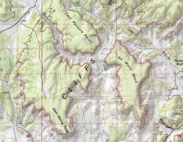
You can see the layout of the White Cliffs in the distance. To get up to it they would have had to ride their horses up the river at the bottom of these images, into the flatland plateau below the cliffs, all the way till they reach the White Cliffs. Their camp site was beyond the cliffs in the maze of canyons that went for miles. It would be difficult to find them in there.
I made a short film about this place and about how I shoot aerial photography from my bush plane in these remote environments. If you can take a look at this film below.
Astounding Geology In Escalante Grand Staircase
Located within the Colorado Plateau physiographic province this area holds an astonishing array of archaeological, geological, biological, paleontological, and historical resources. This huge, spread out collection of mesas, cliffs, canyons and plateaus, is vibrantly distinguished by a vast array of colorful geologic formations. It truly is one of the most interesting places on the planet
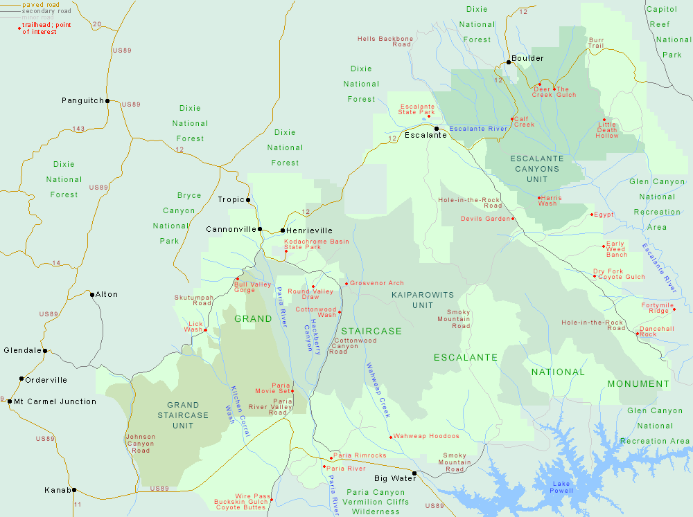
If you have ever visited Bryce Canyon National Park, Zion National Park, the Grand Canyon or Glen Canyon then you have been on the Escalante Grand Staircase as it encompasses all of these places plus much more. In the map below, the White Cliffs (focus of this post) are located on the left side in the "Grand Staircase Unit" along that river called Kitchen Corral Wash.
The image below is another view of the White Cliffs with Kitchen Corral Wash river running down through the cliffs. In the distant horizon you can see the higher mountains on the Paunsaugunt Plateau and directly below them the Pink Cliffs of Bryce Canyon. And in a downward stepping terrace fashion you have the Gray Cliffs, White Cliffs, Vermilion Cliffs and finally the Chocolate Cliffs at the bottom of the image.
 White Cliffs and Kitchen Corral Point ~ Click to Enlarge
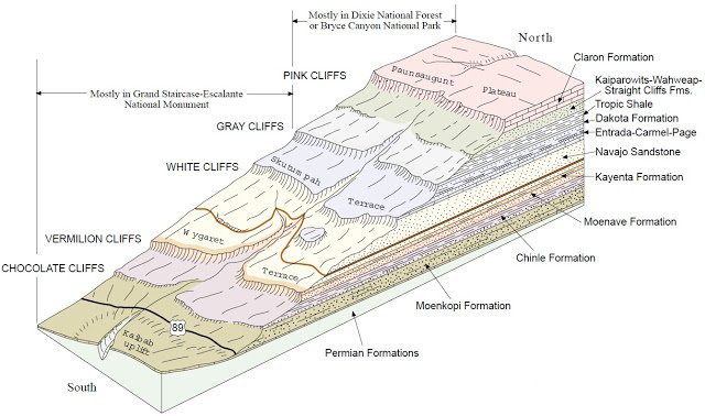
To have a good understanding of where exactly we are in this image, take a look at this side view geologic cutaway map of the Grand Staircasegeology. The Green cross-hair represents the position I was at when flying and filming these first two photographic images above and the Blue cross-hair represents the direction I was pointing the camera.
 Stratified Layer Diagram ~ Click to Enlarge
(Research Source)
This is an ancient place with at least 275 million years of Earth’s history exposed in a vast variety of unusual rock formations that range all the way from the Permian Period to the Cretaceous era. The Grand Staircasebegan to form when vast Cambrian oceans lapped onto the broad continental shelves of the still-forming North American continent. Later,Triassic rivers and streams in their flood stages left silty and muddy deposits on the ancient landscape.
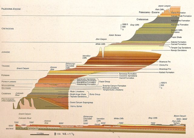
This following graphic is a good view of the stepping geology in the staircase showing the river in the above images as it cuts its way down from the Pink Cliffs all the way down to the Chocolate Cliffs in the Kaibab Uplift.
Then, sandy “seas” the size of the Sahara deposited windblown sand dunes during the Jurassic Period. Next an enormous, shallow inland, Cretaceoussea left mud, silt and sand on its fluctuating shoreline and sea floor. Lastly, a Paleogene system of lakes deposited layer after layer of their limey deposits. All these ancient geological events occurred in succession, one after the other, depositing a legacy of their presence written in stone.
(Research Source)
 Wygaret Terrace and Skutumpah Terrace ~ Click to Enlarge
The image above is from the same position but here I am shooting towards the north west and you can clearly see the different stepped layers of the staircase as it rises on average about 2,000 ft (609 m) per step. The Pink Cliffs peeking out under the clouds in the middle of the image (horizontally) are the southern edge of Bryce Canyon.
This image is overlooking Wygaret Terrace and Skutumpah Terrace, both part of the lower side of the Paunsaugunt Plateau. First Nations Southern Paiute and Utes named this plateau after the many Beavers that inhabit the area. In their language Pansaugunt, (pronounced "PAWN-suh-gant") means "home of the beavers".
The following image is a very clear example of then immense sequence of sedimentary rock layers that form a series of topographic benches and cliffs that steps up in elevation progressively from south to north. This is a small unnamed wash near Coyote Springs in the wilderness of the eastern side of Zion National Park in the Vermilion Cliffs.
 Stratified Wash Near Coyote Springs ~ Click to Enlarge
This image below was lensed as I was flying along the Paria River, 40 miles to the west of Coyote Springs. These colorfully stacked bench layers of sedimentary rock show the same colored stratified layers as the wash above, illustrating the geographic size of these multi-layered benches.
 Paria River Stratified Outcropping ~ Click to Enlarge
This following image I took while flying south of Zion National Park along the Johnson Wash River shows a perfect example or large scale area erosion. This is Dobson Bench, one of the many layers that make up the Grand Staircase. Dobson Bench is part of the Arizona Strip, which is the same geologic height in the Grand Staircase as the top rim of the Grand Canyon.
Here you can clearly see how the bench has eroded back towards the left, while leaving a line of 3 “island” mesa benches as an ancient testament to the awesome powers of long term erosion!
 Dobson Bench ~ Click to Enlarge
This following graphic shows the Grand Staircase from the bottom of the Grand Canyon (lower left) to the very top at Bryce Canyon. Please note that the vertical perspective is greatly exaggerated. The lower diagram, is drawn to more realistic proportions, and is a more realistic side-view of the actual topography. These Diagrams are all from Ancient Landscapes of the Colorado Plateau by Ron Blakeyand Wayne Ranney.
Looking southward across the Kaibab Plateau and down into the depths of Marble Canyon, you can see a slight glimpse of Lake Powell on the upper left side of the image below. This view shows the vastness of these large scale layered benches as they are weathering through time eternal in various forms shaped by extremely long term geological forces and erosion from the elements.
 Kaibab Bench to Marble Canyon ~ Click to Enlarge
The Staircase is a huge, harsh expanse, almost two-million acres of plateaus, mesas, buttes, slot canyons - all in an ancient primitive setting. Time is not stopping here, through a combination of powerful and persistent natural forces, it marches onward, slowly, steadily... carving, forming and shaping the land forever.
About The Project
Where Eagles Fly - The American Wilderness Expedition is my personal mission to introduce people to these amazing locations that surround us.I am piloting a bush plane while exploring and filming throughout the remote back-country areas of North America to raise awareness of the 47% of the USA and 90% of Canada that remain unpopulated wilderness.
About The Author
My name is Zedekiah Morse and I'm a Bush Pilot, Photographer, Explorer and Filmmaker. I live in the Rocky Mountains and devote my time and resources to exploring as much of the world as I can by air. If you wish to watch a short film detailing how I do my work and this project, go here.
If you like what you see here upvote and resteemit so that others may experience these wondrous places.
And if you'd like these images to be part of your feed, follow me.
Thanks for your support and Yehaw!!
Fascinating photos and story-line. I love Utah terrain! Thanks for sharing your unique bird's eye view of this very unique area.
My pleasure! Glad you liked it and I totally agree about Utah! A very special place.
Wow, gorgeous photographs! Thank you for including the beautiful state of Washington!
Great Photos & Post Yehaw!
Thanks for sharing & Steem On :)
Yes sir! That I will and thanks for taking time to check it out
Nature is amazing as if I want to go there and take some beautiful pictures.
And you should!!!
Thanks @skypilot
Good to see the wild bunch wearing the most popular hat of the era. The stetson that we all know from the movies was not as common as the bowler. Cool images as always @skypilot.
Yes that was cool I thought. Though definitely posing for the camera, they sure were a dapper lot. And thanks so much for taking time to read the post!
Love the video... great voice... great story. Is that an empty seat behind you?
LOL!! Thanks so much, very kind of you to say... that is no longer a seat as it has been transformed into a cargo space for my camping and camera gear. :) Really gald you liked it!!
incredible writings of my senior I really like and want to learn a lot from you friend
Thanks, very nice of you to say
Thanks you.
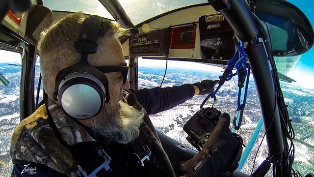
So glad you're doing more like this! I love them! The photographer in me would love to learn more about what kit you use while you're out and how you actually get the shots, from the bottom image it looks like the camera is suspended and that you can actually open the window!? I always wondered how these shots were so clean if you'd shot them through glass!
It truly means a lot to me that another photographer likes my work!! very cool.... I actually shoot both freehand and suspended, either on one cord or both, depending on the wind conditions and type of shot I am going for. The windows open as you see and I always shoot through the open air as going through cloudy plexiglass would cause distortion and light problems. I use different setups depending on what I am trying to accomplish: Hassleblad H5D with a 60mpx back, Canon 6D with onboard GPS ( I use this when I am moving fast around storms and shooting as it helps me keep track of where the shots are when landmarks are obfuscated by the storm clouds) and I am in the process of getting a Phase One Tri-100 MPX rig. That will be outstanding!!!One thing to note, shooting like this is not easy... much to consider when piloting the airplane and shooting simultaneously!
You're welcome! Ah ok, that's interesting to know, makes sense too, I had wondered what happened if you saw something out of another window! Definitely makes a massive difference not shooting through plexiglass!!
Ah fantastic, I bet the H5D is fantastic for this kind of thing! I'd love a Hassleblad but there is no way I could justify a camera that is pretty impractical for documentary type work! I have never used the GPS on my 6D but I can totally see why it would be handy in this kind of situation! Ah wow, the Phase One looks like a stunning camera, I bet you'll love it!
I bet! I had kind of assumed you'd be able to put it in a bit of autopilot but even that would worry me!! Epic multitasking!
Love it! Brings me back :) I took my dad on a journey through Bryce and then to the Narrows in Zion. Later with some friends I repelled off the Corona Arch in Moab. But wow there's always so much to see and experience :) Thanks for the beauty and education! As always!
Awesome! I am glad you like it and can relate to these places like this! Zion and the surrounding area is always full of new supprises!
Greaaaat @skypilot. Extraordinary. You have a great job, plus great skills too. Hopefully you sellau given health and achieve success. Best Regards from me..
Thanks and I wish you success as well.....
Your welcome my friend @skypilot :)