Where Eagles Fly : Escalante White Cliffs ~ Part 1 ~ The Tiny Ranch Along Kitchen Corral Wash
While flying above the high desert to the east of Zion National Park while exploring the wilderness of the Escalante Grand Staircase I came upon this remote and beautiful location where Deer Springs Wash (the creek on the left) and Park Wash (the creek on the right) flow together and create the Kitchen Corral Wash (the creek on the bottom right). I have explored this place a number of times for my project Where Eagles Fly and have found a number of really interesting locations in this area I would like to share with you in this post.
Tiny Ranch in Kitchen Corral Wash
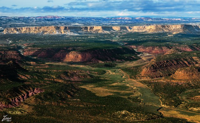
In this image I lensed while flying over Telegraph Flat you can see on the horizon the pink Hoodoo cliffs of Bryce Canyon National Park standing like eternal palisades, keeping watch over the ancient landscape below.
Running horizontally across the middle of the image are the White Cliffs and located below them are the Vermilion Cliffs. The green brush plateau below the White Cliffs is called the Deer Range and the canyon on the right side of the range is called Box Elder Canyon.
All of these brightly colored formations are part of the Escalante Grand Staircase. This 275 million year old geologic formation begins on the north side of the Colorado River down in the bottom of the Grand Canyon National Park and moves north and west up to Bryce Canyon and west to Zion National Park.
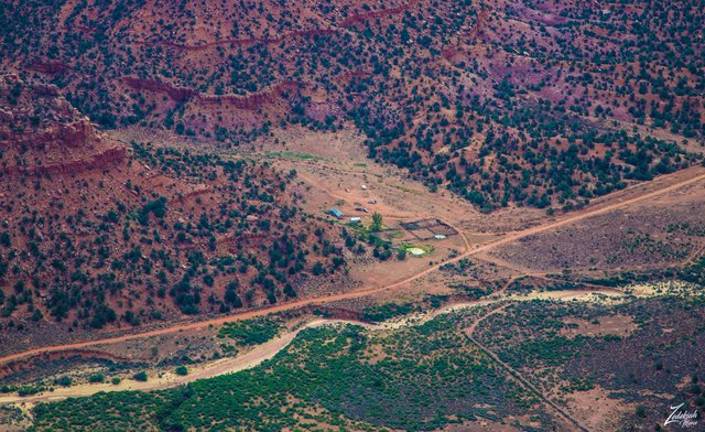
 Kitchen Corral Wash ~ Click to Enlarge
In the image above, on the right side of the image, along that narrow dirt road, there sits a really small ranch. This is a very remote location and from the way the ranch is designed it looks as though they do a lot of horseback riding.
I have passed over this a ranch number of times in my explorations and a couple of times I waved at the guy on horseback. One of these days I will probably land there and pay them a visit. I'd love to give them a print of this image! I think this is a very cool remote little getaway.
 Kitchen Corral Ranch in the Spring ~ Click to Enlarge
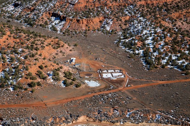
This ranch sits at the bottom of a ridge called Kitchen Corral Point. This reddish purplish ridge is a prehistoric Mesozoic geologic formation known as the Moenave Formation. This area is loaded with dinosaur fossils!
 Kitchen Corral Ranch in the Winter ~ Click to Enlarge
The following image is a panorama of the are with the tiny ranch in Kitchen Corral Point located in the bottom center of the image. You can clearly see the full length of Bryce Canyon National Park on the horizon and the entire length of this section of the White Cliffs along the middle of the image.
The protruding Monadnock on the right side is Mollies Nipple which rises up above Starlight Arch in the mysterious Starlight Canyon. And on the distant right side of this image lays Kodachrome Basin State Reserve, a geologic fairyland of monolithic stone spires, called sedimentary pipes, with accentuated multi-hued sandstone layers that reveal 180 million years of geologic time.
On of the really amazing facts about this image is that this little ranch is the only sign of habitation in this entire huge area covered in this image. I LOVE this location! What a serene place to be.
 Panorama ~ White Cliffs & Kitchen Corral Wash ~ Click to Enlarge
I lensed these images at different times while exploring this awe-inspiring wilderness area for my ongoing project, "Where Eagles Fly". This is Part I of a 4 part series about this location. Stay tuned to the next 3 posts to get the full story and watch a film made while flying in the area.
Here is a link to google maps for the location of this beautiful place.
About The Project
Where Eagles Fly - The American Wilderness Expedition is my personal mission to introduce people to these amazing locations that surround us. I am piloting a bush plane while exploring and filming throughout the remote back-country areas of North America to raise awareness of the 47% of the USA and 90% of Canada that remain unpopulated wilderness.
About The Author
My name is Zedekiah Morse and I'm a Bush Pilot, Photographer, Explorer and Filmmaker. I live in the Rocky Mountains and devote my time and resources to exploring as much of the world as I can by air. If you wish to watch a short film detailing how I do my work and this project, go here.
If you like what you see here upvote and resteemit so that others may experience these wondrous places.
And if you'd like these images to be part of your feed, follow me.
Thanks for your support and Yehaw!!
Upvote & resteem ... follow @lurehound
hey lurehound! Thanks so much, I just went to your blog! Please post more about the lures and fishing!!! I love that stuff, especially the antique lures!
All’s well that ends well.
I certainly hope so!
Woooow, that was a unique flight. I enjoyed travelling with you very much 😀 I can’t wait to go on trip with you next time ✈️
Thanks for your kind words Gaja! Very nice of you!!! Hope you saw the second part of this journey...parts 3 and 4 are on their way as well.
Come fly in the White Mountains in NH!
I am planning on it!! This is all part of my project "Where Eagles Fly" and the first part is in the Rocky Mountains from Canada to New Mexico, the 2nd part is the Appalachian Mountains and surrounding areas and will include New Hampshire.