Chistla Butte & Comb Ridge ~ Sacred First Nations Diné Sites
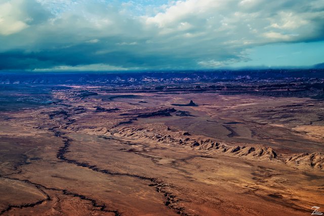
This is the southern end of the mighty Comb Ridge, an 80 mile long monocline that runs from this location northward to the Abajo Mountains. Known to the First Nations Diné (Navajo) people as "Tséyíkʼáán" this ridge is peppered with many cliff dwelling ruins from the Ancient Anasazi people.
This entire landscape, south of the Four Corners area (where Utah, Arizona, New Mexico and Colorado come together) is part of the Navajo Volcanic Field. Scattered throughout the field are 80, highly eroded volcanic necks (diatremes) which were created during the Oligocene age through the Miocene age.
Research has shown that the majority of the volcanoes in the Navajo Volcanic Field erupted violently. This typically happens if the magmas are rich in dissolved gases (water, carbon dioxide, sulfur dioxide, etc.). Minette magmas were not rich in dissolved gases.
So why the violent eruptions? The magmas came in contact with groundwater, which boiled the water into steam while confined underground. The steam pressure then increased until it overcame the strength of the overlying rocks, resulting in an violent explosion and subsequent creation of a surface crater (maar). Volcanologists call these phreatomagmatic eruptions (a.k.a. hydrovolcanic eruptions).
(Research Source)
An interesting thing about this image and the volcanic necks shown here. These are now visible because the earths surface in these areas has eroded and been pushed up to a point where what used to be buried far underground is now exposed. This erosion has occurred over the span of millions of years.
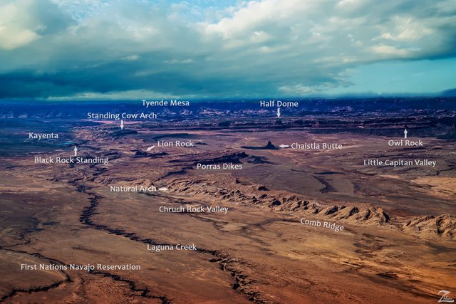
Location Key
In this image there are numerous locations that are part of the Diné (Navajo) traditional history. I have created an image location key as shown in the following image which denotes each location.
The following is information on some of the more interesting locations:
Chistla Butte, Lion Rock, Owl Rock and Half Dome are all volcanic neck remnants while the Porras Dikes are a very peculiar volcanic plug formation.
Chistla Butte (a.k.a. Turkey Butte) in traditional Diné (Navajo) teachings is called “To Support The Sky’s Underside”. This is one of the 5 sacred rocks that holds the sky up; according to Blessingway Singer Billy Yellow “Should this butte fall, the world would end”.
(Research Source)
Owl Rock is also known as both “Spindle (wool-twiner) and Slim Rock and is a spindle left behind by the Holy Beings.
(Research Source)
These images and story are from my ongoing project in which I am trying to raise awareness of the 47% of the USA and 90% of Canada that remain unpopulated wilderness.
Where Eagles Fly - The American Wilderness Expedition is my personal mission to introduce people to these amazing locations that surround us.
If you like what you see here upvote then resteemit so that others may experience these wondrous places as well. And if you'd like these images to be part of your feed then follow me.
Yehaw!!


So beautiful!
Thank you! Your music is amazing, what a beautiful voice and style.
Thank you so much!
beautiful! followed you! I want to see such a landscape from a plane! (although it looks pretty small and scary :0 )
wonderfull nature good work ❤️
You make me want to take the ride from Tucson up that way. It looks like some of the most beautiful sites to go camping. I've lived all over the country but this area has such a deep spiritual connection. Some areas near Bisbee AZ even have old hunting ground that ancient people used to hunt mastadons. Your posts inspire me to explore. I look forward to more!
Excellent!! That is the goal of these posts, to inspire others to experience these places first hand! Thanks so much for taking the time to check it out! yehaw
I like this.