Pray for sinabung (sumatra utara)

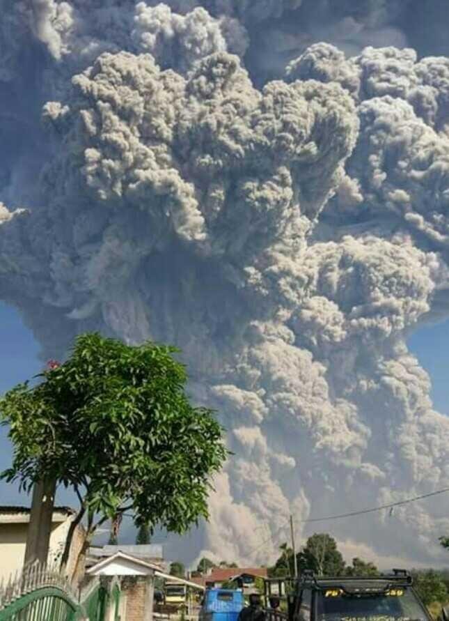


Mount Sinabung in Karo Regency, North Sumatra province, erupted again on Monday (19/2/2018), at around 08:53 pm. The eruption height is estimated to reach 5,000 meters from the summit of Mount Sinabung.
Following the eruption, the hot clouds slid to a distance of 4.9 km to the south-southeast sector and 3.5 km to the east-southeast. According to the Center for Volcanology and Geological Hazard Mitigation (PVMBG) the impact of this hot cloud is observed still in the sterilized area.
After that the volcanic ash flew westward according to the wind.
Regional Disaster Management Agency Karo noted there are five districts exposed volcanic ash of Mount Sinabung include District Three Nderket, Umbrella, Munthe, Lau Balang, and Namanteran. The most affected dust of volcanic dust is integrated in District Three Nderket and District Payung.
"In the two sub-districts, almost all villages are hit by volcanic ash," said Kabar Emergency BPBD Karo, Natanail Peranginangin as reported by Antara.
The impact of the eruption of Mount Sinabung also occurred in the Village Million People, District Namanteran. In the area there was a pebble that hit the house when the eruption took place. The pebbles caused most of the villagers to leave the village to avoid the unwanted things.
"But now it has stopped and the residents have returned to their village," said Natanail.
But Assistant Karo Kali Karo district government said the eruption of Mount Sinabung had no impact on tourism in the area although had emerged due to dark clouds due to the many volcanic dust post-eruption. "Until at 11:00 pm, was a little dark," said Siang.