Found old picture → That's why I got my sailing licenses.
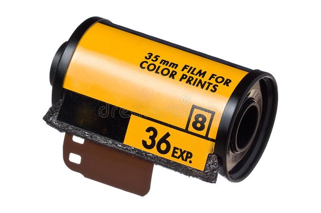
I have a Praktica Super TL, which I still use from time to time. The good old style to create photos the analog way without being able to view them right away.
For those who don't know a thing about this camera:
Praktica cameras were produced in Dresden by the company Pentacon (Kombinat VEB Pentacon Dresden). The camera was produced from 1968 to (around) 1976.

(source: museum-digital)
Technical specs:
- TTL exposure metering
- horizontal shutter with exposure times between 1/500 and 1 second, additional setting for bulb (time exposure and flash)
- Lens mount: M42x1 thread
- Film speed adjustable from ASA 8 to ASA 1600
- Viewfinder: Pentaprism with Fresnel screen, in the centre of the viewfinder there is an additional microprism ring.
- Exposure Metering Indicator on the Right Side of the Viewfinder
- Dimming and measuring button separate from the trigger
- Flash units can be connected to two different contacts (long-burning flash bulbs/electronic flash), the synchronisation time is 1/30 s.
- shutter release lock with viewfinder display
- Power supply for exposure metering: Button cell 625 in the underside of the housing. Because the original button cells are no longer produced because of the mercury used in them and the exposure measurement does not yet have a bridge circuit, such as that of the "L series", a special adapter is required today for voltage adjustment when using replacement batteries. Alternatively, special zinc-air batteries can be used, which supply the correct voltage but are short-lived after commissioning.
- Frame counter on the top of the unit (resets automatically when the rear panel is opened)
- dimpled camera cover
- Rectangular connector on the viewfinder for attaching eyepiece accessories
Price: 537,- Mark + Pancolar 1,8/50mm: 329,- Mark (east-germany)
How much that would be in € today can not answered, since there was no "official" exchange rate. The price in west-germany was 459.00 DM, which is around 790€ today.
Well, so it happened that I found the camera after a few years again and saw that the film had only 2..3 photos left. I had to think for some time how long the film must have been in the camera and this must be something between 12 and 13 years – wow. Of cause I was curious if it would be still develop-able, so I took the 2 pictures and spooled the film back.
Oh boy, what a feeling.
No SD-card or USB-cable – you gotta have to have to turn a small crank several times until you hear the film snapping.
(source: dreamstime)
The next problem was: Where to get this thing developed? After some research I found PixelNet. It’s simple: Type in your address and hit send. After a few days you’ll receive a bag via mail - fill out the form, put the film in the bag and send it back (for free). After a few more days you’ll get the developed film back and an invoice: 9,66€
![]()
Even with a film this old the pictures are pretty good! While sliding through ex-girlfriends, building my garage, a friends new born baby, some of my bikes and other stuff I found some real early sailing pictures! Actually this must have been the 2nd or 3rd sailing trip, I ever did on a modern yacht.
That's why I got my sailing licenses:
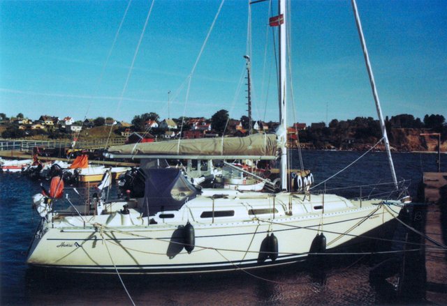
The ship, a Hanse called Macadama is the reason! Well not the ship but the skipper. I did sail with him the previous years, and it was nice, however on that trip he did a navigational mistake. He didn’t want to do a detour, so he skipped a cardinal ton and we hit this stone with around 7kn:
I was in my cabin at this moment, trying to get some sleep, but was thrown through the closed door into the saloon. Everything was flying around and I still could hear the keel scraping at the stone. We seemed to have hit it directly and the boat came to a dead stop in like 0,2s …
There was a lot of damage. Water came into the ship through cracks in the hull. The mast was pushed into the deck, the standing backstay was stretched, The support of the engine cracked and so on. To make things short: The repair did cost around 35000€.
I could maybe understand why the skipper ignored the cardinal sign, but I could not understand his reaction after the crash:
He said: “Well, it won’t cost more than 600€” (that’s the deposit for the boat on charter).
To me it sounded more like:
“It’s not my boat, so I don’t care”.
This was the moment I decided to get my own licenses. I hate when people don't handle borrowed things like if they were their own. I ususally prepare a list with things I damaged, already were damaged and what I was able to repair. After the trip I hand this list over to the charter company and they are usually happy about that. This way I never lost my deposit. Actually the last 5 years in greece I did not pay any deposit.
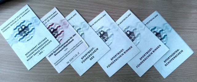
And one year later, I had them. So I started to charter and learned a lot. Many years greece and baltic sea. Now my own ship and next year the Atlantic and Caribbean Sea :) ... and knock-knock: No heavy ground contacts, injuries or crashs.
Maybe thats why I am a bit paranoid if the water gets shallow and always use the fairways at nighttime, even if this means I have to use the engine...
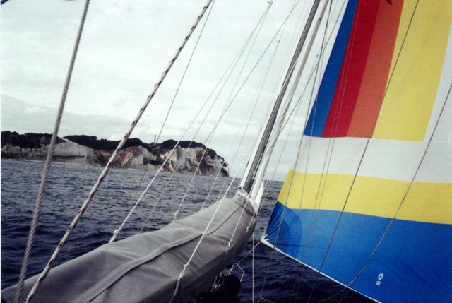
Alright, enough of this! Enjoy the photos:
Arnager / DK:
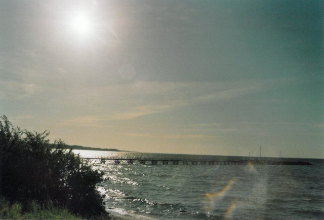
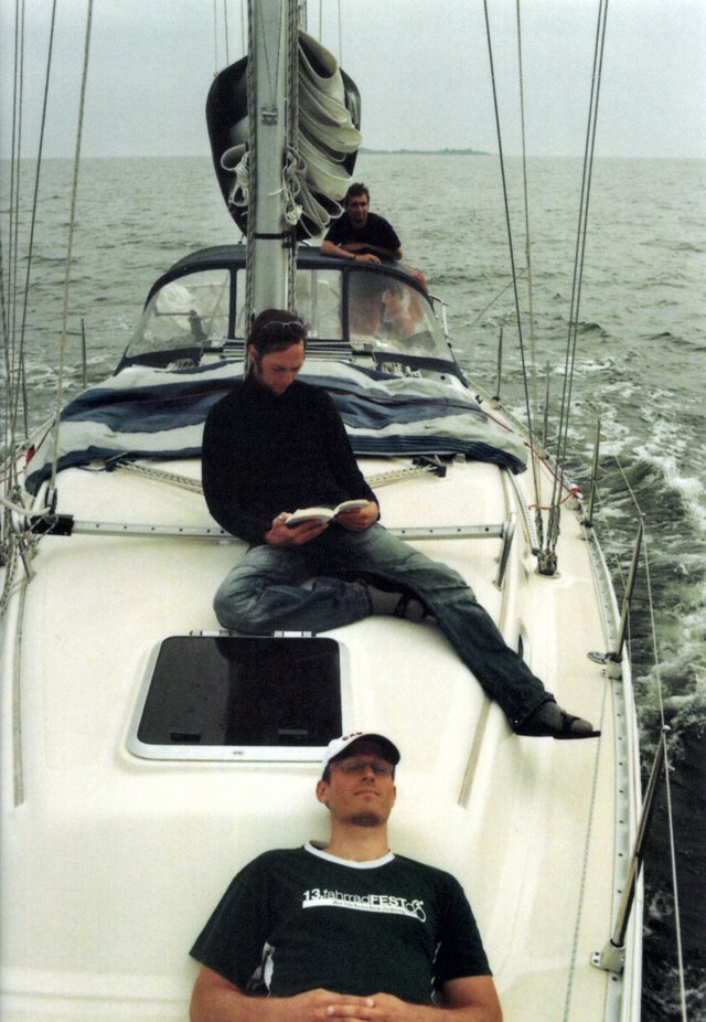
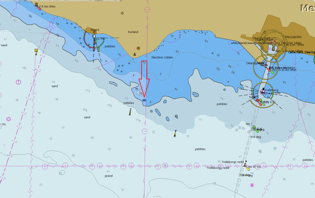
Skåre / SWE (right before the crash...):
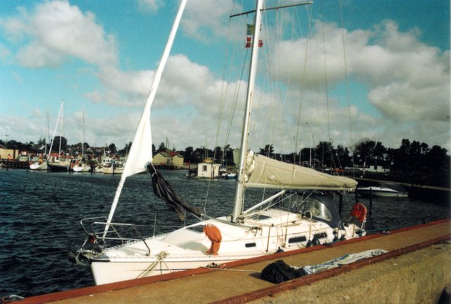
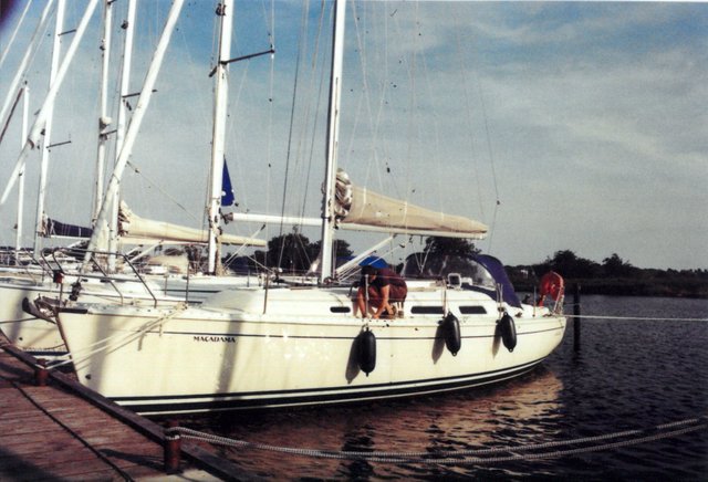
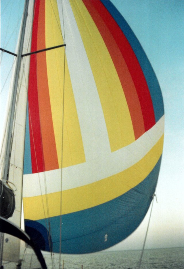
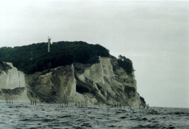
Møn / DK:
And yes: I ordered a new film for this camera. And this time it won't be in there for the next 13 years! Actually I am curious how the quality of the print-outs will be...
Segler auf Steem? Knot!

Wow that's amazing. Pictures look great. I don't think I know how to use SLRs anymore. Hahaha.
Posted using Partiko Android
lets see, i just ordered a black/white film for this camera
Great story to go along with the pics - thanks for sharing!
Those kind of people I totally dont understand. A boat is like a baby when you it. What a mentality
We also had an experience like this a couple years back. Once a year in august is the annual carnival in Anguilla. Everybody from all neighboring islands rent out a boat with friends and goes to there. Now when you live in that region you are always capable of steering a boat, but because this carnival makes you messed up we decided to rent a boat with a captain.
Well....I can tell you, the road back was the most scary one I had in my life. The South west corner of Anguila has a narrow channel through rocks and we alllllways all go around it, especially when its dark. This captain dude slammed the boat through the rocks missing the rocks at like 2 cm.. After that he races over the Anguilla/SXM channel (which is notorious for being rough) with 20 drunk people on board and finally with docking loosing one of his engines with a big bang.
The guy was a high as a kite and it was a miracle we all didnt die that night. Since then...I even look more sceptical to every captain Im riding with
Sherricks Bay? According to Navionics, it's 4.9 metres deep and nearly 200 metres wide, so from the map it doesn't appear that bad.
At the other hand, I'd trust the locals more than the map, and what's safe in quiet conditions and low speeds may be totally unsafe in rough weather, high speed and darkness :-)
Im checking navionics and totally not seeing the whole line of rocks that are sherricks bay.
Id say that from that 200 meters there is about 30 actually safe to got though. Especially when its dark and the moon is your only friend Id say dont be a hero an try to go in between, just go around Anguilita (the small rocky island there)
Navionics is really not to be trusted
To be honest, I think my reaction would also be something like ... "I'm glad I have an insurance ..."
Yea, thats what they are made for ;)
But it was not necessary to trying to skip 10 minutes...
If "it will only cost me 600 euro if we crash the boat" was (consciously or not) a part of the decision process when he oversaw the buoys, then yes, that's despicable.
I must confess that I can be a bit careless myself also - it's not because I have an insurance, I really hate doing insurance claims (and I've asked for the deductible amount from payouts - "egenandel" - to be high, shit happens, and if it isn't too big I'd like to deal with it myself without involving the insurance company).
I'm usually careful to pass on the correct side of cardinal and lateral marks, but some of them really are there just for informing the bigger ships on where the official shipping lane is going , or warning ships about some "shallow" place four meters below - or warning bigger ships that there are shallow areas less than a nautic mile away on the wrong side of the mark ... such marks are often not much helpful for smaller boats. We always watch the map carefully, if there is deep water all the way around the mark and it seems obvious that it's safe to pass the marks at the wrong side, and we have some good reason for doing so, we often do.
In Norway we have plenty of lateral marks, and not so many cardinal marks. The lateral marks can be tricky, it's not always obvious if one is travelling "with" the marks (green mark to be passed on green starboard side), "against" them or even "across". Like, we have this island which can be passed on both sides (it also has a low bridge going to the mainland), it's very shallow quite far out from the island, and there is the red mark there. If turning to the starboard (to enter the harbour there) one will be passing with the island on the port side of the boat, and one needs to ensure the red mark is on the port red side of the boat - everything OK and correct. However, the stick is probably not meant to be seen by boaters going straight (going to the next harbour), passing with the island on the starboard side. Then it's needed to pass with the red mark on a good distance at their starboard green side, even when going to port, and that's not quite right. They really should have used a cardinal mark instead.
Sometimes the lateral marks are even used to mark "pass on the starboard or port side of this danger, don't go in the middle between the marks" - which is really bad as the lateral marks most often are marking the edges of the shipping lane, "go between those marks, not outside".
The yellow special marks can also be tricky, quite often they mark areas where one is not supposed to enter, other times they mark areas where it's forbidden to anchor up or simply marking the end of a sewage pipeline. It's often non-trivial to find out.
We've had three minor incidents (not including some of the clumsier harbour approaches) on this trip. First it was my attempt to do shortcuts, "it's high water, of course we'll manage to pass on the inside of this island" (Wadden sea - and no, everyone we talked with afterwards just laughed it off, impossible to do that route with out boat), eventually we did bump into the ground (luckily very early on) and we had to turn around. When deciding on doing the short-cut, I had those things on my mind:
He did not oversaw the bouy :) It was in sight. He checked the plotter and it said 4m. However in the other (paper) chart there was a warning about stones.
In the Stettiner Haff I usually try to go over shallow spots aswell. But there is only mud and sand. But the south coast of sweden constists mainly of rock and stone. This is shown in every chart and also if you check the coast, then it's made of stone aswell.
The other un-understandable reason is: The bouys are placed there for a reason, which is to mark the stones. No reason to ignore them.
I have done very shallow spots in greece, which is stony aswell. However, if it's a close call I checked the spot with the dinghy first and looked for some landmarks to do the same route with the bigship :)
The passage between Elefanisos and Peleponnes is such an example:
In the Greek Water Pilot is the passage quite well explained, it's an interesting zig-zag course and something for people who love a challenge ;)
The reason is quite often to mark for big ships going five metres deep that it's only four metres deep at the "wrong" side of the mark - hence, when seeing such marks and for some reason wanting to go on the wrong side of it, I usually consult the map carefully before deciding. If the mark is not on the map, then I always obey it - if it is on the map and it appears it's there to warn the bigger ships it's only four metres deep on the wrong side, then I consider it doesn't apply to me ... so I could totally have done the same mistake myself. But yeah, maps aren't to be trusted, and one should be very careful in rocky terrain.
I had a pretty hard hit myself, luckily only in three knots, but it was bad enough that a mirror fell out of its socket and crashed in the floor of the bathroom. It was close to land ... too close apparently ... no sea marks there and the map (Navionics) showed deep enough. I was angry with myself, it was an accident that I could very well have avoided - this was my stomping ground, I knew (from my swimming experiences) it was shallow close to land on this point.
Interesting observation we made deeper in the comments here, on a very rocky and dangerous passage that looks totally safe on Navionics.
Møns Klint ... horrid, that fishing equipment ...