My country Nigeria
My country Nigeria is situated in the mighty curve of its home continent, Africa. Nigeria is part of West Africa. It is completely located north of the equator (between 4° and 14°N) and the east of the Greenwich meridian (between 3° and 15°E). Our neighbours are all French-speaking (Cameroun, Niger, Benin and Chad), except for Western Cameroun in the southeast where English is spoken.
.svg.png)
Nigeria on the continent Africa
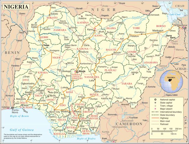
The boundaries of my country for most part are artificial. The boundary cuts off some Yoruba speaking people to Benin Republic in the west and some Hausa speaking people to Niger in the north. It is only in the south where the land is boundary is the shoreline and in the northeast where it follows close to the crest of the Bamenda Cameroun Mountains which can be said to be natural.
The position and location I have described above have some significance to its geography, which i am going to discuss:
Being located in the central curve of Africa, it is easy to reach the various parts of the continent from Nigeria, except for the southern parts of South africa. Most parts are within three hours flying time from either Abuja, Kan or Lagos.
Its location between latitude 4° and 14°N north placesit squarely within the tropics where the overhead sun crosses twice a year, and where the prevailing winds change direction i.e.180° during the two distinct seasons of the year.
Being altogether east of the Greenwich meridian, Our local time is always ahead of that of countries west of the meridian, like Sierra Leone, Brazil or USA and those on the meridia, like Ghana or Britain.
Nigeria faces the land to the north and the sea to the south. This result in dry continental climatic influence wheen the winds blow from the north, and wet marine climatic influence when it blows from the south.
In Nigeria we are English speaking, while all the other countries surrounding us are francophone. We must therefore learn french to be able to communicate with them effectively.
Size of Nigeria
In area, Nigeria is a compact country of 923,768 sq km, about 1100km from north to south, and 1300 km from west to east.
In population we are 186 million strong and increasing at an average rate of 2 - 2.8 percent per annum.
By way of comparison, Nigeria is four times the size of Ghana and covers one-seventh the area of West Africa, though it is only one-third the size of Democratic Republic of Congo in Central Africa. In terms of population and development we are the giant of Africa and largest on the West African sub region.
The size of Nigeria confers on it certain advantages as well as expectation, which include the following:
We have within our borders, a wide variety of physical environment, people and rich natural resources. That is the reason why the term unity in diversity is sometimes used in describing our country.
Nigeria population and purchasing power makes it a very important market for both her own goods and goods from other lands. No wonder why many countries are keen on doing trade with Nigeria.
As the result of the above factors, the country is important in international affairs, and other nations, particularly in Africa, look up to her leadership and watch her progress with great interest and expectation.
One country many state
Nigeria was not always one country, nor was it always made up of as many states as we now have. Four major empires and main city states that existed at one time or the other in different part of Nigeria. These are, the Sokoto Caliphate, Bornu Empire, Benin Empire and Oyo Empire.
We became one country in 1914, independent in 1960 and a republic in 1963. We started with three regions (northern, eastern and western) in 1951, then four in 1960, broke into twelve states in 1976, ninteen in 1987, thirthy in 1991, and added six more in 1996.
In 1997, Nigeria became a federation of thirty six states operating a federal constitution drawn up and approved in 1994/1995.
Tourism
The Yankari National Game Reserve is an important stopover for migrating birds (some 600 species), and also has an healthy elephant population. The Okomo Sanctuary is home to the endangered white throated monkey. On the grasslands of the savannah you will find camels, antelopes, hyenas and giraffes. An area of 30,100 sq km is protected (2003), or 3.3 per cent of the land area. In the country as a whole 26 mammal species and 15 bird species are thought to be endangered (2014).
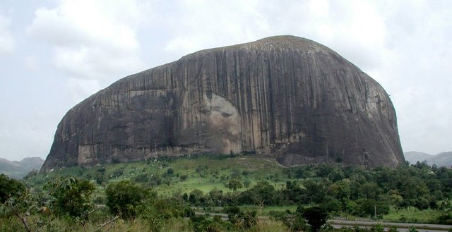
Also the Olumo rock in Abeokuta, Zuma rock in Suleija, Mambilla plateau, Obudu plateau are well known tourist destination and can be visited at any time of the year.
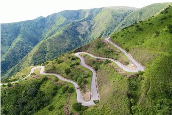
Obudu Plateau
.svg)
Visit Nigeria today and you will find your time here interesting with the people who are always open to recieving visitors.
Reference
https://en.wikipedia.org/wiki/Nigeria
http://www.bbc.com/news/world-africa-13949550
http://thecommonwealth.org/our-member-countries/nigeria
You received a 80.0% upvote since you are a member of geopolis.
To read more about us and what we do, click here.
https://steemit.com/geopolis/@geopolis/geopolis-the-community-for-global-sciences-update-3
If you do not want us to upvote and comment on your posts concerning earth and earth sciences, please reply stop to this comment and we will no longer bother you with our love ❤️
i love this post, am soo proud to be a Nigerian #thumbup @donfelix
thanks
Nice info about Nigeria!!
The roads looks scary though XD
Its a road on the Obudu plateau
Great post bro.. I was thinking on writing about Nigeria too.. But you beat me to it... One love
Thanks brother, there is more to write.
Congratulations! This exceptional post has been featured in Episode 8 of The STEEM Engine Express Podcast. Click the link to hear what I had to say, and keep up the good work!
Thanks ethan
You're welcome! Glad I can support your post!
Wow at the longest points from north to south my state not country is 1,862km with a total of 2.5million squared kilometers with a population of only 2.million. 92% of us live in the bottom left cnr of our state.
Also have you checked out @steemitworldmap. You could add this post there too. They share it out.
why occupy only a small portion of vast land?
thanks, i will check @steemitworldmap out.
Our population isn't big enough, the resources are concentrated around these areas and it's super bloody hot the further north you go. Not to mention more crocs. Haha.
hahaha, Our crocs have almost gone into extinction even some of the snake species too. They make delicious meal for some locals and leather. Our government have done nothing to stop this.
Oh wow I guess they would be good for both those reasons. Good work on using what's available but it's a bit sad that it's happen close to extinction.
Congratulations @donfelix! You have completed some achievement on Steemit and have been rewarded with new badge(s) :
Click on any badge to view your own Board of Honor on SteemitBoard.
For more information about SteemitBoard, click here
If you no longer want to receive notifications, reply to this comment with the word
STOP