Other Earthquakes Occur Repeatedly in Aceh. #Pray For ACEH
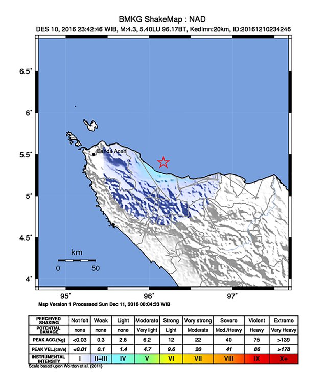
Aceh, December 10, 2016, 23:42:46 AM GMT earthquake again rocked Aceh with Scala 4.3 Rickter strength in depth of 20 km, the location of LU 5.4 96.17 BT.
The information I get from Aceh Pidie Jaya, community strongly feel restless, they are afraid of aftershocks will be back. Most of them chose to sleep on the porch of the house, just in case.
This is the schedule table Earthquake based METEOROLOGICAL, CLIMATOLOGICAL, AND GEOPHYSICAL AGENCY :
No |
Longitude |
Time Earthquake |
Magnitude |
Depth |
Territory |
1 |
2016-12-10 17:54:30 UTC |
5.38 - 96.01 |
5 |
10 Km |
32 km Northwest KAB- PIDIE JAYA -ACEH |
2 |
2016-12-10 17:54:30 UTC |
5.56 - 95.75 |
5 |
10 Km |
32 km Northeast KAB-ACEH BESAR |
3 |
2016-12-10 17:54:30 UTC |
-131.78 |
5.3 |
10 Km |
54 km Northeast SERAMBAGIAN BARAT-MALUKU |
4 |
2016-12-10 17:54:30 UTC |
5.19 - 96.36 |
6.4 |
10 Km |
18 km Northeast KAB-PIDIE JAYA- ACEH |
5 |
2016-12-10 17:54:30 UTC |
-130.72 |
6.4 |
524 Km |
120 km Northeast FLORESTIMUR-NTT |
6 |
2016-12-10 17:54:30 UTC |
4.33 - 127.67 |
5.6 |
124 Km |
110 km Northeast KEP-Talaud-SULUT |
7 |
2016-12-10 17:54:30 UTC |
-136.55 |
5 |
171 Km |
184 km Northwest MALUKU TENGGARA BRT |
8 |
2016-12-10 17:54:30 UTC |
-127.05 |
5 |
12 Km |
96 km east SUMBAWA WEST-NTB |
9 |
2016-12-10 17:54:30 UTC |
-139.06 |
5.7 |
10 Km |
86 km Northeast MALUKU SOUTHEAST BRT |
10 |
2016-12-10 17:54:30 UTC |
-139.19 |
5.1 |
60 Km |
95 km Northeast MALUKU SOUTHEAST BRT |
11 |
2016-12-10 17:54:30 UTC |
4.35 - 126.39 |
5 |
62 Km |
49 km Northwest KEP TALAUD- SULUT |
12 |
2016-12-10 17:54:30 UTC |
-138.3 |
5 |
87 Km |
58 km Northwest Maluku Tenggara RABRT |
13 |
2016-12-10 17:54:30 UTC |
-133.21 |
5 |
10 Km |
43 km Southwestern NTT ALOR- |
14 |
2016-12-10 17:54:30 UTC |
3.41 - 126.06 |
5.2 |
34 Km |
68 km east KEP SANGIHE- SULUT |
15 |
2016-12-10 17:54:30 UTC |
-136.66 |
5 |
184 Km |
179 km Northwest MALUKU SOUTHEAST BRT |
16 |
2016-12-10 17:54:30 UTC |
-119.44 |
5.3 |
10 Km |
93 km Southwestern Gunung Kidul in Yogyakarta |
17 |
2016-12-10 17:54:30 UTC |
-136.98 |
5.6 |
122 Km |
154 km Northwest MALUKU TENGGARABRT |
18 |
2016-12-10 17:54:30 UTC |
-122.44 |
6.2 |
69 Km |
127 km Southeast KAB-POOR-JATIM |
19 |
2016-12-10 17:54:30 UTC |
-120.32 |
5.2 |
10 Km |
96 km east PACITAN-JATIM |
20 |
2016-12-10 17:54:30 UTC |
-120.27 |
5.1 |
10 Km |
89 km east PACITAN-JATIM |
21 |
2016-12-10 17:54:30 UTC |
-112.94 |
6 |
10 Km |
271 km Southwestern LEBAK-BANTEN |
22 |
2016-12-10 17:54:30 UTC |
-136.66 |
5 |
166 Km |
176 km Northwest MALUKU SOUTHEAST BRT |
23 |
2016-12-10 17:54:30 UTC |
2.82 - 95.21 |
5.2 |
10 Km |
92 km Northwest KAB- SIMEULUE- ACEH |
24 |
2016-12-10 17:54:30 UTC |
-142.6 |
5.3 |
10 Km |
52 km Northwest Jayapura PAPUA |
25 |
2016-12-10 17:54:30 UTC |
1.32 - 125.79 |
6.1 |
10 Km |
75 km east BITUNG-SULUT |
26 |
2016-12-10 17:54:30 UTC |
1.97 - 127.25 |
5.2 |
42 Km |
78 km Northwest HALMAHERABARAT-Malut |
27 |
2016-12-10 17:54:30 UTC |
-133.13 |
5 |
84 Km |
77 km Northwest TIMORTENGAHUT-NTT |
28 |
2016-12-10 17:54:30 UTC |
-113.29 |
6.5 |
654 Km |
120 km Northeast SUBANG-JABAR |
29 |
2016-12-10 17:54:30 UTC |
-155.33 |
6.7 |
10 Km |
422 km Northeast Port Moresby PNG |
30 |
2016-12-10 17:54:30 UTC |
4.17 - 126.43 |
5.2 |
46 Km |
34 km Northwest KEP-Talaud-SULUT |
31 |
2016-12-10 17:54:30 UTC |
4.87 - 95.54 |
5 |
124 Km |
14 km Northwest KAB-ACEHJAYA |
32 |
2016-12-10 17:54:30 UTC |
-136.12 |
5.4 |
10 Km |
70 km east BAY BINTUNI- PAPUABRT |
33 |
2016-12-10 17:54:30 UTC |
1.79 - 127.41 |
6.2 |
117 Km |
52 km Northwest HALMAHERABARAT-Malut |
34 |
2016-12-10 17:54:30 UTC |
1.52 - 127.12 |
5 |
100 Km |
55 km Northwest HALMAHERA WEST-Malut |
35 |
2016-12-10 17:54:30 UTC |
-134.42 |
5.1 |
348 Km |
248 km Northeast MALUKU WEST |
36 |
2016-12-10 17:54:30 UTC |
-135.81 |
5.3 |
252 Km |
273 km Northwest MALUKU SOUTHEAST BRT |
37 |
2016-12-10 17:54:30 UTC |
-142.57 |
5.2 |
10 Km |
84 km northeast one-PAPUA Jayapura |
38 |
2016-12-10 17:54:30 UTC |
-142.66 |
5.3 |
10 Km |
62 km northwest part-PAPUA Jayapura |
39 |
2016-12-10 17:54:30 UTC |
-137.07 |
5.2 |
128 Km |
143 km Northwest MALUKU SOUTHEAST BRT |
40 |
2016-12-10 17:54:30 UTC |
-120.57 |
5.1 |
10 Km |
108 km east PACITAN-JATIM |
41 |
2016-12-10 17:54:30 UTC |
-140.49 |
5.6 |
10 Km |
82 km Northeast MAMBERAMO middle- PAPUA |
42 |
2016-12-10 17:54:30 UTC |
-142.6 |
5.3 |
10 Km |
71 km Northwest Jayapura PAPUA |
43 |
2016-12-10 17:54:30 UTC |
-107.28 |
5.4 |
19 Km |
79 km Southwestern SOUTH BENGKULU |
44 |
2016-12-10 17:54:30 UTC |
-142.35 |
5.1 |
10 Km |
80 km Northwest-PAPUA Jayapura |
45 |
2016-12-10 17:54:30 UTC |
-142.66 |
5.6 |
10 Km |
65 km Northwest Jayapura PAPUA |
46 |
2016-12-10 17:54:30 UTC |
5.51 - 125.69 |
5.3 |
179 Km |
198 km Northwest KEP-Talaud-SULUT |
47 |
2016-12-10 17:54:30 UTC |
-132.87 |
5.2 |
113 Km |
94 km Southwestern CENTRAL MOLUCCAS |
48 |
2016-12-10 17:54:30 UTC |
-137.23 |
5 |
104 Km |
152 km Northwest MALUKU TENGGARABRT |
49 |
2016-12-10 17:54:30 UTC |
-106.63 |
5.1 |
10 Km |
160 km Southwestern BENGKULU BENGKULU- |
50 |
2016-12-10 17:54:30 UTC |
-124.9 |
5 |
10 Km |
292 km Southwestern DENPASAR-BALI |
51 |
2016-12-10 17:54:30 UTC |
-121.5 |
5 |
10 Km |
192 km Southwestern TRENGGALEK-JATIM |
52 |
2016-12-10 17:54:30 UTC |
-121.27 |
5.1 |
10 Km |
51 km Southeast-Sulawesi PALU |
53 |
2016-12-10 17:54:30 UTC |
-144.13 |
5.1 |
88 Km |
69 km Northeast Yahukimo- PAPUA |
54 |
2016-12-10 17:54:30 UTC |
0.5 - 98.51 |
5.5 |
19 Km |
79 km South East South Nias SUMUT |
55 |
2016-12-10 17:54:30 UTC |
-128.77 |
5 |
69 Km |
33 km Northwest SUMBATENGAH-NTT |
56 |
2016-12-10 17:54:30 UTC |
-141.33 |
5.5 |
64 Km |
52 km east MAMBERAMOTENGAH-PAPUA |
57 |
2016-12-10 17:54:30 UTC |
-103.02 |
5.8 |
21 Km |
155 km Southwestern Mukomuko-BENGKULU |
58 |
2016-12-10 17:54:30 UTC |
-130 |
6.1 |
537 Km |
105 km Northwest FLORESTIMUR-NTT |
59 |
2016-12-10 17:54:30 UTC |
-135.01 |
5 |
10 Km |
134 km east SERAMBAGIANTIMUR-MALUKU |
60 |
2016-12-10 17:54:30 UTC |
-136.07 |
5.3 |
184 Km |
229 km Northeast MALUKU WEST |
Source : Link