Atlantis - Geoglyphs

Cite: https://fthmb.tqn.com/hJvdsapHd3JAq_J9SUJpmpo9eNE=/768x0/filters:no_upscale()/about/Uffington_Horse-588379425f9b58bdb34ca8f9
For a theory we find evidence in a strange spot and start with a picture of the Uffington Horse geoglyph in the U.K.. Why start here? We are looking for a war as one possibility of the end of Atlantis. What happens after great battles? What happens after great catastrophes? Peoples and nations build monuments to the dead.
Please think far outside the box as we take our intellectual adventure toward Atlantis. All over the world are geoglyphs. The interesting thing about them is many are so huge that even though they are explained, like the pyramids of Egypt and the Americas we have to ask ourselves: Gee, we are just barely surviving primitive peoples and we have time to create these geoglyphs for fun, worship, and because Art is Art?
I am not knocking our scientists but in order for people to do these things, while ingesting hallucinogenic plants and mushrooms and drinking alcohol that has not been distilled, they must have enough transportation, shelter, food and water. If you have ever participated in construction, and a geoglyph is landscaping construction, great organization is required.
One supposes that captured enemies could be used to make the geoglyphs as slaves. Again, great organization is necessary because some of these earth glyphs are absolutely huge. The lines that are straight are perfectly straight. The object is proportional and in many cases can only be seen from the air or space. The largest known geoglyph is the Sajama Lines which when laid end to end are three times the width of the United States. Somehow someone would have to be able to communicate with the highly organized geoglyph construction crew from a vantage point far away on a high mountain. Did they use flags? Were mirror signals used? Was there a paper drawn plan? Things like this are not just eyeballed. They were thought about, designed, approved, and built. The steps to complete these geoglyphs is evidence of high technology.
The oldest geoglyphs appear to be in California, United States. One can suspect that geoglyphs started there? The big question is: Did people all over the Earth suddenly get the bright idea - "Let's make geoglyphs!" all on their own or did someone from California travel the world and say, "Hey Dude and Dude-ette -" to people in South America, Kazakhstan, U.K., Arabia, and Australia to start a geoglyph promotion tour? We all know about fads but? How could they travel and why when the world was thought to be flat?
Perhaps there was some sort of mind control that shouted out to the human inhabitants of the world, "Build Geoglyphs and Pyramids, Now!" Just doesn't seem right does it? No these geoglyphs question everything we have been taught and that is why the geoglyphs are first!
Atlantis was supposed to be very high technology according to legends and myths. According to all that we know high technology should have been impossible.
There are some interesting facts about many geoglyphs. They are perfectly oriented and supposedly there were no compasses or surveyor equipment. The people who did it used hand tools, stakes, and string to layout and guide the perfect making of something that would last thousands of years. The first in south America was found in 1962 or thereabouts.
Let's face it. An army most likely moved across the Earth on a mission to conquer. Wherever there was a battle a geoglyph was made in commemoration. The other possibility is a plague or catastrophe hit but then again, is this what primitive people think of doing? So far I have mentioned dark events but joyous occasions could also be the inspiration. Why make something that can only be viewed from the air? Are we certainly we evolved in a evolutionary manner?
Where geoglyphs are located is often in very desolate areas and in deserts. Here is an example of a similar place. To the west of Salt Lake City, Utah is the salt flats of the Great Salt Lake. As one drives, there are places where people stopped their cars and lined up rocks to form words and designs but those geoglyphs are very small and a car was used to get there.
Most geoglyphs are said to be made on crusty soil which is usually some sort of baked desert floor or a thin rock layer which is removed so only the lighter colored soil beneath is visible. Others are made by digging a trench. Again, some sort of hand made hoe or adze was supposed to be used which was made of a leather thong to tie a piece of tough rock to a stick? 24,000 kilometers long?
As you read what is below and see images realize this is a tiny portion of what information is out there. Even so, while reading it in several places the learned strongly argue against any wild theories springing up because all can be explained. Yes, one agrees it all can be explained but are the explanations likely? In deference to those who came up with the explanations, remember many of the explanations were made without the additional knowledge of what people found elsewhere on the planet over time. It is when the arm chair archaeologists like us look at all the data that we can help science answer a lot of questions thanks to the internet and Steemit.
Now, several years ago I wrote a series of articles about why radio carbon dating is not necessarily correct. Without a long scientific explanation it boils down to this - we live in a dynamic universe not a static one. The probability that the decay of carbons is perfectly linear is not likely. Rather, natural, cosmic, and unknown forces could accelerate or decelerate the rate of decay throughout time so that decay is actually something like a sine wave. Fortunately, scientists give the dates within a range. Even that is not perfect but it is wise to think that at some point other corroborations of dates and periods of events might occur to shed further light on history.
Some geoglyphs are explained as irrigation ditches - that can be believed. Others would most likely not be irrigation ditches. And in western North America people have a tendency to put letters on a mountainside and they are big. The letter is for the high school and or the name of the town. If you were examining one these giant letters thousands of years into the future, what would you think it was there for? Remember everyone drove up there in a car to make these letters on the side of a mountain. In many cases the letters are made of gravel hauled up the mountain by truck.
Now, cited excerpts and images from websites on some geoglyphs around the world:
• Black Desert of Jordan Works of the Old Men
Hundreds of thousands of geoglyphs are known in or close to lava fields throughout the Arabian peninsula, named by the Bedouin tribes who live in the Black Desert of Jordan Works of the Old Men. (The Works of the Old Men also included ruins and inscriptions). First brought to scholarly attention by RAF pilots flying over the desert shortly after the Arab revolt of 1916, the geoglyphs were made of stacks of basalt, between two to three slabs high. They are classified into four main categories based on their shape: kites, meandering walls, wheels, and pendants. The kites and associated walls (called desert kites) are thought to be mass kill hunting tools; wheels (circular stone arrangements with spokes) appear to be construction for funerary or ritual use, and pendants are strings of burial cairns. Optically Stimulated Luminescence (OSL dating) on examples in the Wadi Wisad region suggest they were built in two main pulses, one in the Late Neolithic about 8,500 years ago and one about 5,400 years ago during the Early Bronze Age-Chalcolithic. See Athanassas and colleagues below for details.
• The Geoglyphs of Turgai
in the Eurasian steppe of northern Kazakhstan are dated to the early Iron Age (ca 800 BC). There are about ~60 found to date, most of them located on geological points of high relief. They vary in size from 90-436 meters (300-1,400 feet) in length, and shapes include squares with diagonal lines, crosses, circles, or simple rows or lines. One known as the Turgai swastika is a three-rayed triskelion, built of earth ramparts about 30 centimeters (1 foot) high. See Motuzaite Matuzeviciute and colleagues.
• Nazca Lines 
• The famous Nasca lines were created on the coastal desert of Peru between 100 BC-AD 700 by removing the upper level of dark stones making up the desert pavement to reveal the brighter sandy layer below. There are more than 1,500 examples, attributed to water and irrigation, walking, ceremonial activity, ritual clearing, concepts of radiality like those expressed in later Inca ceque system, and perhaps astronomy. Recently Ruggles and Saunders looked at Nasca's LC51 Labyrinth, an asymmetrical group of straight lines which double back on each other. They believe it is a single pathway leading to and from a center, constantly disorienting the walker as s/he goes along the way: to get to the center 60 meters (200 feet) from the exterior, you must walk a distance of 4.4 kilometers (2.7 miles).
• 
• Cite: https://en.wikipedia.org/wiki/Nazca_Lines
• Atacama Giant
• By Emilio from Germany/Chile - The Giant of Atacama, CC BY-SA 2.0,
• 
• The Atacama Geoglyphs are located in the coastal desert of Chile. There were more than 5,000 geoglyphs built between 600-1500 AD, made by moving around the dark desert pavement. In addition to figural art including llamas, lizards, dolphins, monkeys, humans, eagles, and rheas, the Atacama glyphs include circles, concentric circles, circles with dots, rectangles, diamonds, arrows, and crosses. One functional purpose suggested by researcher Luis Briones is that of identifying safe passage and water resources through the desert: the Atacama geoglyphs include several examples of drawings of llama caravans.
Cite: https://www.thoughtco.com/geoglyphs-ancient-art-of-the-landscape-171094
Sajama Lines
Recent research revealed that this network of lines covers an area of 22,525 square kilometers, approximately fifteen times larger than the area covered by theNazca Lines in Peru. Rough estimates put their linear length at approximately 16,000 kilometers, roughly three times the breadth of the United States. As such, the Sajama Lines are the largest archaeological site in the Andes and might be considered the largest artwork in the world.[1][2]
The lines were created by scraping aside vegetation and the dark surface material consisting of soil and oxidized rock and exposing the lighter subsurface material. Like the better-known Nazca Lines (which differ from the Sajama Lines in that some of the Nazca are depictions of animals) neither the purpose of these lines, nor how the makers achieved such precision, are completely understood.[1]
Scholars at the University of Pennsylvania describe:
While many of these sacred lines extend as far as ten or twenty kilometers (and perhaps further), they all seem to maintain a remarkable straightness despite rugged topography and natural obstacles. The sheer number and length of these lines is often difficult to perceive from ground level, but from the air or hilltop vantage points, they are stunning.[1]
Many believe that the lines were originally used by indigenous people when they made sacred pilgrimages. Interspersed among this network of radial lines and aligned to where lines meet are wak'as (shrines), chullpas (burial towers) and hamlets, making the area a unique cultural landscape. Though the region is now sparsely populated there is evidence that some of the lines are still in use as footpaths.[1]
Cite: https://en.wikipedia.org/wiki/Sajama_Lines
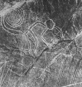
The Blythe Intaglios or Blythe Geoglyphs
are a group of gigantic figures found on the ground near Blythe, Californiain the Colorado Desert. The intaglios are found east of the Big Maria Mountains, about 15 miles (24 km) north of downtown Blythe, just west of U.S. Highway 95 near the Colorado River. The largest human figure is 171 feet (52 m) long. The intaglios are best viewed from the air.
The geoglyphs or intaglios (anthropomorphic geoglyphs) were created by scraping away layers of darker rocks or pebbles to reveal a stratum of lighter-valued soil. While these "gravel pictographs" are found through the deserts of southeastern California, human figures are found only near the Colorado River. The figures are so immense that many of them were not observed by non-Indians until the 1930s.[1] The set of geoglyphs includes several dozen figures, thought to be ceremonial in nature.[2] Many of them are believed to date from the prehistoric period, but their age and the identity of their creators are still uncertain. Jay von Werlhof and his collaborators obtained 13 AMS radiocarbon dates for the figures, ranging from 900 BCE to 1200 CE.[3]
Cite: By Ron's Log - http://www.flickr.com/photos/ronslog/400353265/, CC BY-SA 3.0, https://commons.wikimedia.org/w/index.php?curid=1742586
Some links to follow:
The Top Ten Geoglyphs around the world:
Many Geoglyph Images:
Google Geoglyph Image collection:
Related Articles
Please Upvote and Please Comment: What you might come up with might change the direction of this theory.
Excellent post!! thank you for sharing
Thanks, glad you liked it my friend @mars9
When things happen, they happen all over the globe.
Powered flight - the Chinese had kites for thousands of years, and so, how did it come about that the wright brothers built an airplane only two weeks before a Frenchman did so?
The same with the radio.
The same with many many other inventions.
So, archaeologists and such think of tracing something back to a central source. However, it is much more likely that the idea developed all over the world. And if you listen to the aethers, or to the muses, you can hear and watch as new technologies come into being. And every time, there is more than one group doing it.
From a holy text point of view. There are so many similar tales. It is easy to think of it all coming from one source. Or, it is better to say that there was one event, and many eyes saw that event?
Things like the Jesus story. 12 disciples. Birth from the virgin. Died 3 days, was resurrected. The docudrama Zeitgeist goes into many many similarities across much space and time. So, is this one instance, or a cycle that repeats? Since time is circular, I would suggest this is a cycle that repeats. This is even more evident if you study the ancient buddhist texts who catalog their teacher's comings and goings.
Excellent observation, thanks. Kites would explain how the geoglyphs could be built. What do you think someone up in a kite could use for reliable communication with those on the ground?
Note: I have not heard of kites being found in North and South America but that does not mean they did not exist. Balloons could have also been discovered and used but again, communication with the ground.
Yes, a truly great observation.
I just thought of something based on your kite observation: At the time the geoglyphs in the U.K. were have supposed to have been made the native Britons dyed themselves blue and were the equivalent of Stone Age cavemen according to the Roman conquerors. Therefore: something really bad had to happen in order for the ancient british to descend to that level from when they built Stonehenge and the geoglyphs: what does everyone think?
Excellent work dear friend @ jeff-kubitz, truly admirable and interesting, congratulations, thank you very much for sharing
Thank you so much for your interest in this topic my dear friend @jlufer