Tropical Humidity Returns Occasionally With Heat & Downpours
Tropical Humidity Returns Occasionally With Heat & Downpours
Tropical Humidity Returns Occasionally With Heat & Downpours
One day of relative comfort has come and gone and we will begin to see an increase in humidity going forward. Tropical humidity returns with some days very warm, some days hot. Each day we will throw in the risk for downpours though some days the risk will be higher than others. Today we are seeing clouds to the south and some of those will sneak in. We also see a rather busy regional radar showing downpours and thunderstorms from Eastern Virginia to the Delmarva Peninsula. Those downpours are moving northward but they will only get so far north today; possibly as far north as Southern New Jersey before they get pushed out to the east. Temperatures today will be in the 80s as the discomfort level starts to rise.
EASTERN SATELLITE


Local Mount Holly New Jersey radar shows the east west band of heavy downpours creeping northward into Southern Delaware. Areas to the north remain quiet on the radar.


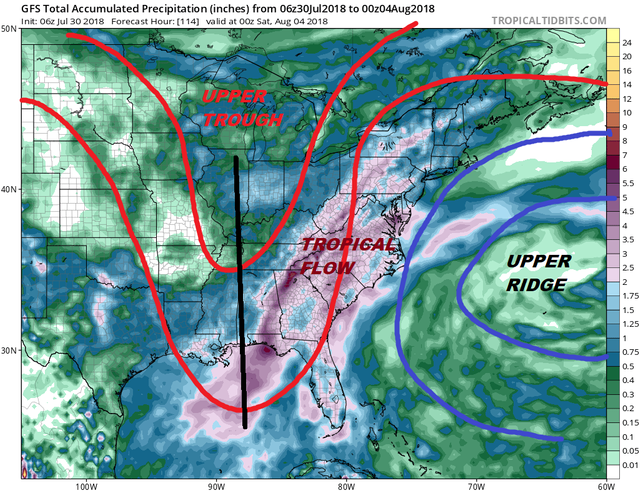
We will once again being under a southerly flow along the east coast for much of this week. An upper high sits to the east and trough sits to the west. The axis of this trough is a little further west than the one from last week. This I think allows for more variability in the shower activity. Some days it will be active while other days less so. We will not see a continuous rain obviously there will be dry stretches for sure.

It is always tough to figure rainfall amounts in a tropical pattern because thunderstorms provide a huge amount of variability in to the equation. In general the rain fall amounts forecast would suggest that the heavier rains will be to the west of the coast when they happen. I've drawn in the jet stream pattern forecast for midweek which should the axis of the upper trough to the west a bit further west than last week. The upper ridge in the Atlantic will try to build back westward later this week as the trough weakens. This could open the door to a couple of days of hot weather next weekend with temperatures edging into the 90s. We do not see anything extreme as far as heat is concerned however over the next seven days. From a day to day standpoint the forecast is pretty much the same. You can expect very warm and humid conditions with clouds and some sunshine. Highs will be in the mid to upper 80s..a little cooler at the shore...and watch for some downpours and thunderstorms each day from Tuesday through Friday. You can nudge the temperatures up for the weekend a few degrees.
Please note that with regards to any tropical storms or hurricanes, should a storm be threatening, please consult your local National Weather Service office or your local government officials about what action you should be taking to protect life and property.

GET JOE A CIGAR IF YOU LIKE
LATEST JOESTRADAMUS ON THE LONG RANGE
Posted from my blog with SteemPress : http://www.meteorologistjoecioffi.com/index.php/2018/07/30/tropical-humidity-returns-occasionally-with-heat-downpours/
Big storm is coming be aware : O
we shall see. pattern seems ripe for the East