Florence Rains Moving East Flash Flooding
FLORENCE RAINS HEAVY WITH FLASH FLOODING

Rain totals for most areas so far are in the 1 to 2 inch range but some areas are done to the west and some are playing catch up as the remnants of Florence and a cold front push on through. The front is moving slowly so the rains will last into the evening along the coast making for a tough beginning to the evening commute.
EASTERN SATELLITE


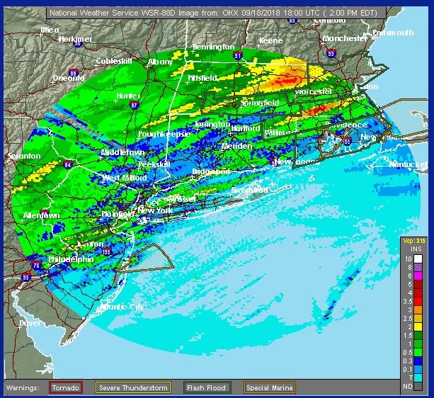
Radar as of 3pm show the rains are done north and west of Philadelphia & New York City but we still see some heavy rains and thunderstorms in Central and South Jersey as well as on Long Island and right along I-95 in Connecticut.


Nothing much has changed with weather models going forward. We should see some improvement tonight with leftover clouds and skies should go partly sunny on Wednesday even though the front is going to be close by offshore. Thursday looks partly sunny. Wednesday's highs will be in the upper 70s and lower 80. Thursday's highs will be in the 70s.

The next front approaches on Friday with sun and clouds with highs in the upper 70s and lower 80s. The front still looks rather weak so there might be a passing shower Friday night. Saturday looks to be the better of the 2 weekend days at this point. The push of dry air is going to be limited as the next front stalls to our south. Saturday looks partly sunny however clouds could be an issue Sunday with an onshore flow developing.
Please note that with regards to any tropical storms or hurricanes, should a storm be threatening, please consult your local National Weather Service office or your local government officials about what action you should be taking to protect life and property.
FIOS1NEWS NEW JERSEY
LATEST JOESTRADAMUS ON THE LONG RANGE
Posted from my blog with SteemPress : http://www.meteorologistjoecioffi.com/index.php/2018/09/18/florence-rains-moving-east-flash-flooding/