Florence Rains Heading To Inland Mid Atlantic Northeast Early Next Week
FLORENCE DOWNGRADED TO A TROPICAL STORM 70 MPH WINDS
SUMMARY OF 500 PM EDT...2100 UTC...INFORMATION
LOCATION...34.0N 78.6W
ABOUT 50 MI...75 KM WSW OF WILMINGTON NORTH CAROLINA
ABOUT 25 MI...45 KM NE OF MYRTLE BEACH SOUTH CAROLINA
MAXIMUM SUSTAINED WINDS...70 MPH...110 KM/H
PRESENT MOVEMENT...W OR 270 DEGREES AT 3 MPH...6 KM/H
MINIMUM CENTRAL PRESSURE...972 MB...28.70 INCHES
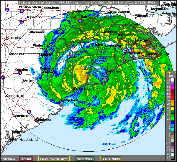
Florence is now well inland and moving westward so there is no danger of Florence emerging back out into the open waters. Tropical storm conditions will last through Saturday in North & South Carolina thanks to the slow movement and rain is going to be insane in some places. 20 to 30 inches of rain will be commonplace in many areas due to the slow movement which you can see clearly on the real time radar.
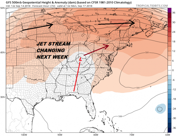
At this point we will be shifting attention to our weather for early next week and what will the remnant low of Florence and the rains that will be eventually moving northward. The upper high over the Great Lakes and Northeast which is giving our area a decent weekend is going to break down. The jet stream in Canada drops southward which then interacts with the upper feature that represents Florence. This will pull it northward and then kick it to the northeast.
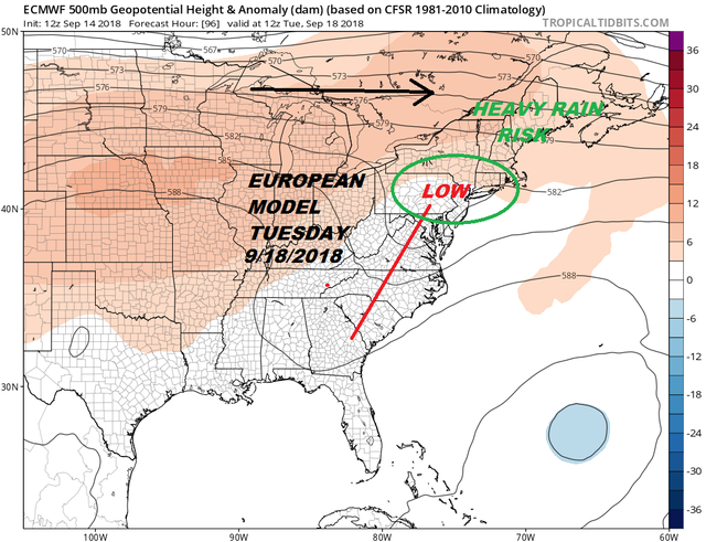
All the models have this idea and of course the usual differences show up. The European model shows a much more intact system as the trough gets kicked eastward. This would take a surface low further south and bring a stronger period of heavy rains beginning later Monday night and lasting through a good chunk of Tuesday.
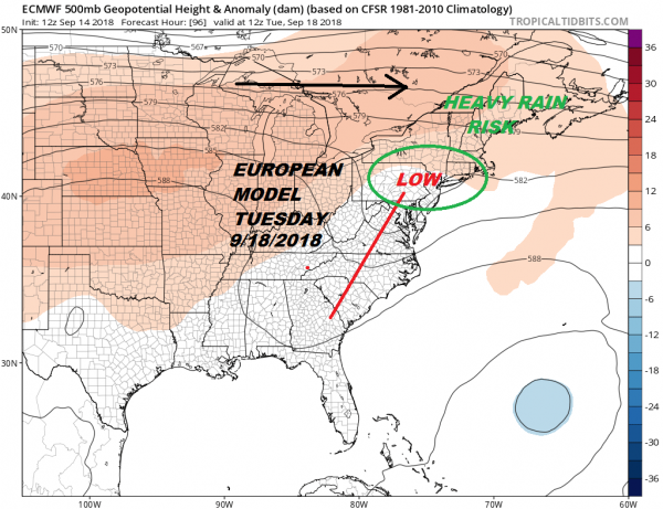
The model differences would mean that we would get 1 to 3 inches of rain on the GFS and double that amount at least on the European which is particularly aggressive with rainfall amounts across Pennsylvania eastward to Southern New England with some areas getting 6 inches plus. This would all fall rather fast so flooding could be an issue on Tuesday.
To the south across the Middle Atlantic States of particular concern Pennsylvania southward through interior of Virginia into West Virginia southward into the Carolina mountains where excessive rains are coming after a rain soaked summer. Some areas in Western Virginia have seen 3 feet or more of rain from mid July to early September so flooding here could be a serious threat from tropical rains.
MANY THANKS TO TROPICAL TIDBITS FOR THE USE OF MAPS
Please note that with regards to any tropical storms or hurricanes, should a storm be threatening, please consult your local National Weather Service office or your local government officials about what action you should be taking to protect life and property.
(Unsupported https://www.facebook.com/plugins/post.php?href=https%3A%2F%2Fwww.facebook.com%2Fmeteorologistjoecioffi%2Fposts%2F10160987589035387&width=500)
FIOS1NEWS NEW JERSEY
LATEST JOESTRADAMUS ON THE LONG RANGE
Posted from my blog with SteemPress : http://www.meteorologistjoecioffi.com/index.php/2018/09/14/florence-rains-heading-to-inland-mid-atlantic-northeast-early-next-week/
LOCATION...34.0N 78.6W
ABOUT 50 MI...75 KM WSW OF WILMINGTON NORTH CAROLINA
ABOUT 25 MI...45 KM NE OF MYRTLE BEACH SOUTH CAROLINA
MAXIMUM SUSTAINED WINDS...70 MPH...110 KM/H
PRESENT MOVEMENT...W OR 270 DEGREES AT 3 MPH...6 KM/H
MINIMUM CENTRAL PRESSURE...972 MB...28.70 INCHES
Florence is now well inland and moving westward so there is no danger of Florence emerging back out into the open waters. Tropical storm conditions will last through Saturday in North & South Carolina thanks to the slow movement and rain is going to be insane in some places. 20 to 30 inches of rain will be commonplace in many areas due to the slow movement which you can see clearly on the real time radar.

At this point we will be shifting attention to our weather for early next week and what will the remnant low of Florence and the rains that will be eventually moving northward. The upper high over the Great Lakes and Northeast which is giving our area a decent weekend is going to break down. The jet stream in Canada drops southward which then interacts with the upper feature that represents Florence. This will pull it northward and then kick it to the northeast.

All the models have this idea and of course the usual differences show up. The European model shows a much more intact system as the trough gets kicked eastward. This would take a surface low further south and bring a stronger period of heavy rains beginning later Monday night and lasting through a good chunk of Tuesday.

The model differences would mean that we would get 1 to 3 inches of rain on the GFS and double that amount at least on the European which is particularly aggressive with rainfall amounts across Pennsylvania eastward to Southern New England with some areas getting 6 inches plus. This would all fall rather fast so flooding could be an issue on Tuesday.
To the south across the Middle Atlantic States of particular concern Pennsylvania southward through interior of Virginia into West Virginia southward into the Carolina mountains where excessive rains are coming after a rain soaked summer. Some areas in Western Virginia have seen 3 feet or more of rain from mid July to early September so flooding here could be a serious threat from tropical rains.
Please note that with regards to any tropical storms or hurricanes, should a storm be threatening, please consult your local National Weather Service office or your local government officials about what action you should be taking to protect life and property.
FIOS1NEWS NEW JERSEY
LATEST JOESTRADAMUS ON THE LONG RANGE
Posted from my blog with SteemPress : http://www.meteorologistjoecioffi.com/index.php/2018/09/14/florence-rains-heading-to-inland-mid-atlantic-northeast-early-next-week/
@sadkitten is countering 50% of @joewxman self-votes for 1 week starting Friday, September 7th 2018 because it is part of last weeks top self-voters. For more details see this post.