To pardon a project-relevant pun...dropping right back in.
To paraphrase Mark Twain (as this feed turns seven with barely any fanfare): If any rumours of my disappearance may have abounded...then they have been gravely exaggerated. (More on that later.) As occasionally happens in these cases, I'm never away for long--not even on Steem(it)/Partiko. (Now, as for my return to wiki-editing...)
Although I wish I could've wrapped up sooner, another round of laptop-storage crisis late in May forced me to give my Rogatia project a break until further notice. Which led to nearly a whole month of tune collecting in the interim--well in advance of Adanson's first summer party (with a brand-new team), starting tomorrow evening (after DBS Dominica's death announcements).
The above paragraph will make sense in context once you realise (if you actually were a reader of this feed in the Google+ days) I'm respectively referring to my long-gestating book projects, Sevton and Unspooled. To refresh your memory from back then, or give you a quick preview (as a newcomer): Rogatia is the fictional North Atlantic island where part of the Sevton Saga is set, while Adanson is an event facility/nature reserve in the northeastern Commonwealth of Dominica village of Marigot (in my forthcoming Unspooled series). One universe has an all-human cast; the other features anthro animal characters à la Disney (or for that matter, Zootopia and Robin Hood).
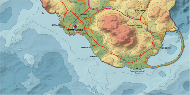
Dealing with the gang at House 4270 next we meet--but for now, turning my attention to the retool of you-know-where. The preview I promised to deliver last time can't wait much longer. In fact, make that a double preview. Below, your first look at the south of Shropshire, one of the country's three provinces (1:352,983):
And along with it, the very first public appearance of Yorkshire (and its 90-mile-long Causeway) anywhere--or rather, its western portion (1:500,000):
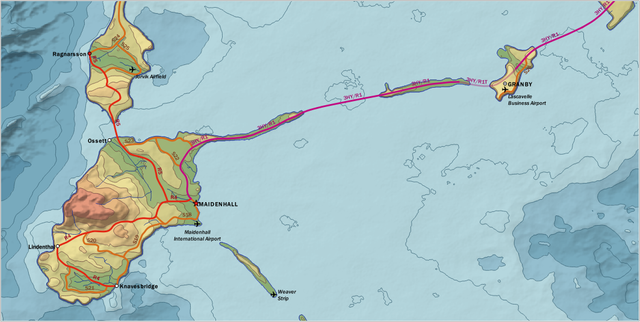
Obligatory technical rundown follows here: The highway colours' RGB values are 193/9/129 (3HY, the Herbert Hancine Highway + Yorkshire Causeway; purple), 226/40/20 (National Routes [R]; red), and 213/109/29 (Secondary Roads [S]; brown), while those for the respective classes' labels are 161/8/105, 164/0/20, and 120/60/30. All labels on the map (including town and airport names) use the Franklin Gothic Medium font, pre-shipped with Windows 10. For the hypsometric/bathymetric tint scheme, you can thank u/caledor123 on Reddit--and this handy tutorial of his. (On land, the step-level intervals are 0, 5, 10, 25, 50, 100, 200, and 400 m; at sea, they go down to -10, -25, -50, -100, -250, and -500 m. Not shown here are 600 m [at Mount Barome] and -1000 m. This non-compromise approach is based on Imhof (2007):317-18--and was adopted on purpose to accommodate the low-lying Weymouth Expanse in Elmshire, which we'll get to another time.)
The new Rogatian terrain was formed using a combination of Wilbur's Fractal Noise feature, and the node-generated ocean layout from early on in the reconstruction attempts. But finding the right Fractal setup was way easier said than done; words cannot express how many long hours the process took me last month. What I ultimately settled on--out of at least three or four candidates--actually brought the landscape closer to its 2008 iteration than what I later tried out afterward. (Long story on how that works the way it does; I'll elaborate either before the one-week window's up, or in a later post.)
- Type = Ridged Multifractal; Operation = Multiply; Seed = 07111973⊙
- H: 1.125
- Lacunarity: 1.85
- Octaves: 12
- Offset: -0.1
- fGain: 17.5
- Amplitude: 1
- Displacement: -35
- XY Scale: 10/10
- XY Origin: -1.2/0.35
That, and a lot of further touchups in the weeks ahead--not to mention it's in 100 m resolution, which gets coarser and blockier the more you zoom in (either on Wilbur or QGIS).
Last but not least: My job was officially done on Tuesday night--but then again, I already had a growing music collection to deal with (Adanson-wise), and that took away a lot of my available time too. (Again, long story.)
¤¤¤¤
So now that we've ticked this off the priority list...on to another one entirely. Which reminds me...
As we reopen the Notebook, it's back to the beats--and the turntables--for the critters whose old crew are wrapping up a grueling three-month post-Michael cleanup stint as we speak, and are ready to serve recently quake-ravaged portions of Ecuador and Peru next month. (Pity this year's Easter Ball had to be cancelled, as well as the protest concert they planned as a replacement; everything from Article 13, to the Avengers: Endgame premiere, to a jazz fest back home in the Nature Island, got in the way. But come the Fourth of July, the efforts of the new management in Marigot will make up for it. Speaking of Article 13, they're now starting to fight back against the big labels--the best way they know how by that point.)
In time to come, the wall map of Rogatia (based on my recent efforts); samples and sheets of Veritas (the gift map), Novissima and Vigesima (south of Jamaica), St. Isabel (north of Hispaniola, but smaller in scope than I anticipated), and Tovasala (where Relformaide, my conlang, is spoken). Until we meet again, happy exploring!
P.S. In case you want to reach out, I Reddit as u/Routhwick every other day or so. That's where I've been otherwise during this frenzy.
⊙ Rogatia's date of independence from the United Kingdom.
From the one, the only, the all-new...
Snapshots generated with QGIS and MS Paint. QGIS is released under GNU's GPLv2; Paint is copyrighted by Microsoft.

![]()
(2558) (Gee, it really has been *that* long, hasn't it?)
Posted using Partiko Android