State of Kassala - Sudan
Kassala State is one of the states of Sudan, with its capital, Kassala, located in the eastern part of Sudan. It is bordered to the north by the Red Sea State, the Nile River State, the west and south by the Gedaref State, and the Eritrean border to the east and south. The state is characterized by the abundance of gardens and orchards and diversity of nature, making it one of the most important tourist areas in Sudan. The project includes the new agricultural Halfa, which is irrigated from the Khashm al-Qirba reservoir along with several other agricultural projects for the production of sugar cane, wheat and maize. It has an area of 42282 square kilometers and a population of 1,527,214
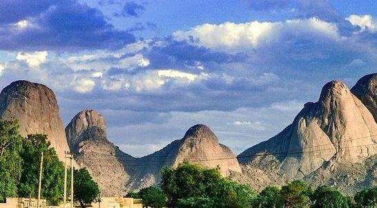
Kassala State was named after the city of Kassala, which took its name from Mount Kassala, one of the most important topographical landmarks in the region. The state of Kassala is one of the states of Sudan, which took its name from its capital.
The emergence of Kassala as an administrative unit to 1840, when the Turks made it an administrative unit in the name of the territory of the Taka, and the emergence of the Mahdia Movement was the territory of Taka theater of wars.
The city of Kassala, the capital of the state, is located 496 meters above sea level, 480 km from the capital of Sudan Khartoum through the plains of the lining in central Sudan, and the central parts of the state, and its location at the top of the Gash River Delta has increased its strategic importance
The state's terrain varies from sandy plains to seasonal valleys and a mountainous mass, most notably the Kassala Mountains, Tuteil and Taka, and is seen as a huge rocky nose.
Mount Kassala rises to about 851 meters above the level of the surrounding plains, which is a huge mass of smooth granite rocks representing the eastern end of the city of Kassala, and separates Mount Kassala from the Eritrean hills to the east with a distance of about 24 kilometers.
One of the most important valleys is the Gash River, a seasonal stream flowing between July and October, and becomes a stream of sand for the rest of the year
*the climate
Temperatures range from 33 to 47 degrees Celsius. The average rainfall in the state is between 750 millimeters in the north and 400 millimeters in the south. This temperature is more like the Hadramout area in Yemen.
Some parts of the state were affected by the wave of desertification and drought that hit the region in the beginning of the 1980s, which led to a change in the geographical nature, where the density of vegetation in some parts, but they faded significantly, and sand covered the soil in a remarkable manner, The areas of Goz Rajab near the Atbara River in the west of the city of Kassala, as shown in the North Delta from the town of Aruma to the town of Dardib on the border of the Red Sea State.
*Photos from Kassala


Is this @originalworks?
Cool post.
Congratulations @watani! You have completed some achievement on Steemit and have been rewarded with new badge(s) :
Click on any badge to view your own Board of Honor on SteemitBoard.
For more information about SteemitBoard, click here
If you no longer want to receive notifications, reply to this comment with the word
STOP