HYPERBOREA - Fabulous Northern Land of Greek Legend
In Greek mythology the Hyperboreans (Ancient Greek: Ὑπερβόρε(ι)οι, pronounced [hyperbóre(ː)ɔi̯]; Latin: Hyperborei) were mythical people who lived "beyond the North Wind". The Greeks thought that Boreas, the god of the North Wind (one of the Anemoi, or "Winds") lived in Thrace, and therefore Hyperborea indicates a region that lay far to the north of Thrace.
This land was supposed to be perfect, with the sun shining twenty-four hours a day, which to modern ears suggests a possible location within the Arctic Circle.
In Russian epics, Indian "Rigveda", Iranian "Avesta", in Chinese and Tibetan historical records, in the German epic, in Celtic and Norse mythology describes the ancient land of the north, like Paradise, where reigned the "golden age". They inhabit the land of old children nice people "gods." People who have a genetic relationship with them, carry them to a particular gene, a special spiritual power "Pharn", which, like the legendary phoenix reborn once, saving and play a pivotal role in the fate of civilization. Those few who felt in himself the call, were looking for the legendary Hyperborea?
"Happy Island, where from the beginning of life on Earth has a Source of Life"? to touching it, awaken their ancient "Pharn," but long time and hard was kept the secret. Thousands of years ago the great Atlantis was swallowed by the Atlantic Ocean. Many researchers believe that the same fate befell Hyperborea, which now lies at the bottom of the Arctic Ocean. But the ancient Tibetan tradition says that: "The White Island is the only area that escaped the common fate of all continents after the accident he can not be destroyed nor water, nor fire, for he is the Eternal Land.".
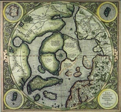
Surprisingly, Tibet has preserved not only the memory of Hyperborea? there begins the path leading to her heart, the greatest sacral center of the world, the Great Pyramid Meru with the surrounding megalithic structures and spiraling road that led to Meru. To see the "path" leading to, use instructions and a map of the ancient Mercator, published by his son in 1595. Unravel the mystery of the map we have tried many cartographers. Insurmountable difficulties in its understanding from researchers because, in her work on Mercator used three different sources - three different cards made by different cartographers, in different projections and with different levels of accuracy. But the main feature, which is not seen, researchers, and Mercator himself did not consider in preparing their own maps, was that the primary sources, maps depicting the area of the Arctic basin in different periods of the Earth's geological history.
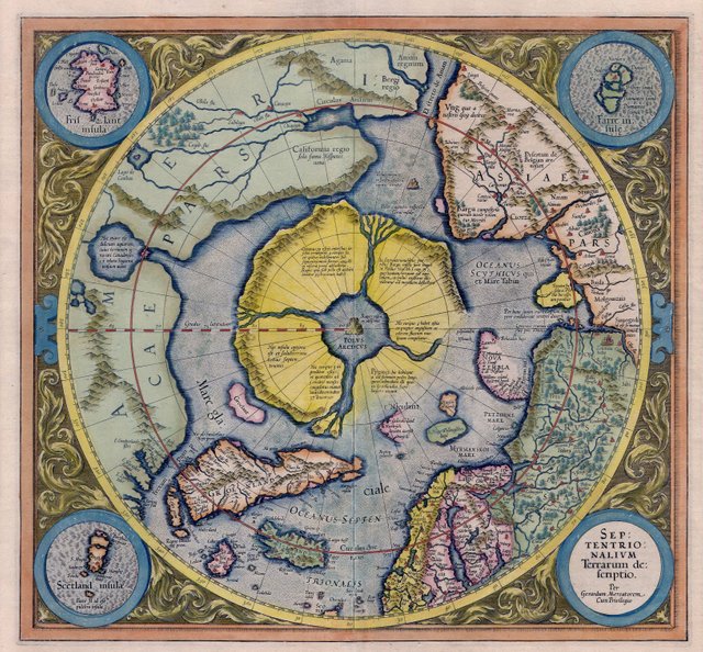
Some reflect the outlines of Hyperborea and the surrounding continents before the flood and the Earth's axis deviation, the other - after. As a result, on the map G. Mercator confusion reigns, in which researchers have not been able to understand. Therefore, in this situation, we will have to look for answers himself. Before we do that, let's start with the principal. Many ancient sources indicate that Hyperborea was at the North Pole.
In particular, the ancient Indian epic "Mahabharata" tells "the North Milk Sea (Arctic Ocean) is a large island, known as Shweta dvipa ... blessed country, there Navel - World Center, around which the sun, moon and stars".
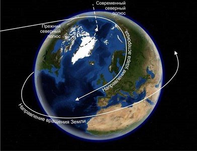
Following the general opinion, G. Mercator puts Hyperborea at the North Pole, not knowing that the disaster to 11,000 BC, the angle of the Earth's axis of rotation and geographic North Pole shifted. There are no studies on this issue. The consequences of almost nothing written, so in this situation we have to understand ourselves.
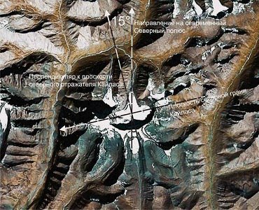
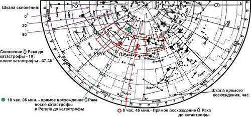
Now we will try to find out where the Earth's axis is deviated, and by how much. To do this, remember that the Great Pyramid of Atlantis watched its northern edge to the north to the south face of Meru. But Atlantis is hidden waters of the ocean, but remained Kailas in Tibet. For convenience, consider Kailas from above using aerial photography. The picture was taken from a height of more than 20 km and is strictly oriented to the cardinal. The central arrow shows the direction of the modern North Pole.
If you like it - follow @fess, vote and comment!