Uncovering K-means Clustering for Spatial Analysis
Uncovering K-means Clustering for Spatial Analysis
omar abdelkefi

Introduction
Underrated (adjective) - Rated or valued too low, according to Merriam-Webster.
The term "underrated" often applies to things or people that don’t get the recognition they deserve. This concept is not limited to individuals or celebrities; it can also extend to technologies and methods. For instance, while players like Kawhi Leonard and artists like NF may be considered underrated in their respective fields, the same can be said for certain machine learning algorithms.
In the realm of artificial intelligence and machine learning, some algorithms receive more attention than others. K-means clustering, an unsupervised learning technique, is one such algorithm that, despite its effectiveness, doesn’t always receive the spotlight it merits. This article explores K-means clustering, especially its applications in geospatial analysis.
What is K-means Clustering?
K-means clustering is an unsupervised machine learning algorithm used to partition unlabeled data into clusters. The goal is to group data points into K distinct clusters based on their similarities. Here’s a simplified overview of the process:
- Initialization: Begin with K randomly chosen centroids.
- Assignment: Assign each data point to the nearest centroid, forming clusters.
- Update: Recalculate centroids as the mean of all points in each cluster.
- Iteration: Repeat the assignment and update steps until centroids stabilize or a stopping criterion is met.
K-means in Spatial Analysis
K-means clustering is particularly valuable for analyzing geographic data, allowing for the identification of spatial patterns and insights. Here’s how it can be applied in various fields:
1. Urban Planning and Development
- Land Use Analysis: Classify urban areas into categories such as residential, commercial, or industrial to aid in zoning and resource management.
- Smart City Projects: Improve infrastructure and services by clustering data from sensors measuring factors like pollution or traffic.
2. Disaster Management
- Risk Assessment: Use historical disaster data to identify high-risk areas, enhancing disaster preparedness and mitigation strategies.
- Resource Allocation: Optimize resource distribution and rescue efforts by clustering affected areas.
3. Public Health
- Outbreak Detection: Detect regions with high incidence of illnesses to target interventions and resources effectively.
- Healthcare Accessibility: Identify underserved areas and guide policy improvements for better healthcare access.
4. Real Estate
- Property Valuation: Cluster property data by location, size, and amenities to assist in accurate valuation and market analysis.
- Development Planning: Identify emerging trends and potential hotspots for new developments.
5. Transportation and Logistics
- Route Optimization: Improve delivery routing and reduce costs by clustering delivery points.
- Traffic Management: Enhance traffic flow and manage congestion through traffic data clustering.
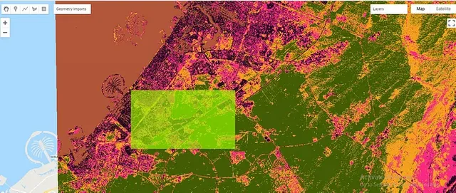
Example: Using K-means in Google Earth Engine
Here’s a code snippet for performing K-means clustering on satellite data in Google Earth Engine:
// Import satellite data from the European Space Agency
var S2 = ee.ImageCollection("COPERNICUS/S2");

// Filter data for Dubai
S2 = S2.filterBounds(Dubai);
print(S2);

// Filter data by date
S2 = S2.filterDate("2020-01-01", "2020-05-11");
print(S2);

var image = ee.Image(S2.first());
print(image);

// Add the image layer to the map
Map.addLayer(image, {min: 0, max: 3000, bands: "B8,B4,B3"}, "Dubai");

// Create a training dataset
var training = image.sample({
  region: Dubai,
  scale: 20,
  numPixels: 5000
});

// Initialize and train the K-means clusterer
var kmeans = ee.Clusterer.wekaKMeans(5).train(training);

// Apply the clustering to the image
var result = image.cluster(kmeans);

// Display clusters with random colors
Map.addLayer(result.randomVisualizer(), {}, 'Unsupervised K-means Classification');

// Export the clustered image to Google Drive
Export.image.toDrive({
  image: result,
  description: 'kmeans_Dubai',
  scale: 20,
  region: Dubai
});
