(Proceeds to hurricane victims) Hurricane Irma the most powerful hurricane
Understanding Hurricane Irma
It seems that President Trump has annoyed another person these last few weeks. All his talk and actions trying to scrap all environmental and climate change policies put in place by Obama seems to really have pissed off Mother Nature.
We have hurricane Harvey, the first major hurricane to hit the US mainland in over ten years, not once but twice. Harvey created the worst flooding recorded ever in Texas with record rainfall and storm surges, leaving 10s of thousands homeless and costing over $70 billion in damages.
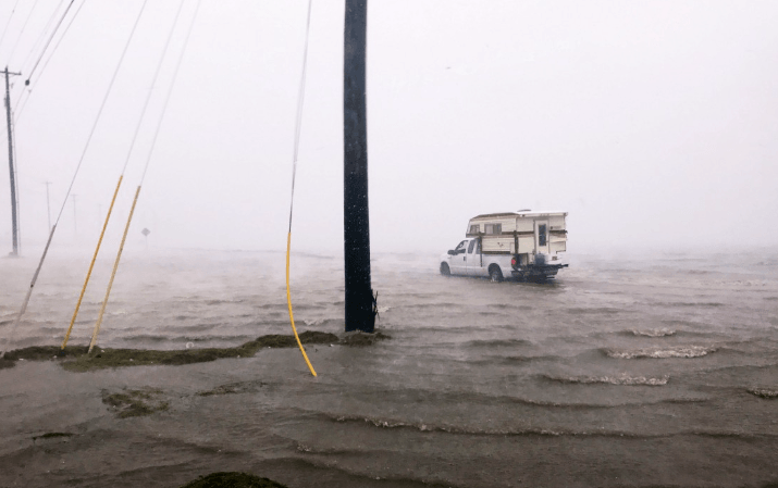
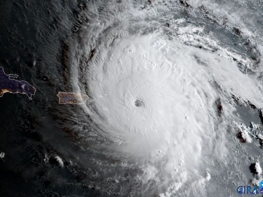
Second we have hurricane Irma. Now this is a seriously scary storm. Hurricane Harvey was bad enough for the poor people who had to suffer through it. Irma however is another story, not only upgraded to a category 5 she is now the most powerful storm ever in the Atlantic ocean and the second in the Atlantic basin (Hurricane Allen in 1980). She has already made landfall on several islands including Barbuda and is on course to hit Cuba and Florida by the weekend. Predictions include consistent winds (not including more powerful gusts) of 185mph and up to 3.3 meters of storm surge. Some islands have already recorded waves up to 5 meters and reports are coming in from French St Martin and Barbuda claiming over 90% of buildings have been destroyed.
“The decisions that we make in the next couple of hours can make the difference between life and death,” said Puerto Rico governor Ricardo Rossello. “This is an extremely dangerous storm.”
There is also tropical storm Jose which is expected to reach category 2 hurricane however this is unlikely to make landfall.
Finally to top off a terrible week for the south coast of the US and the nearby islands we have an extremely large solar flare. This is causing problems as it can cause interference with communications which will stretch an already overworked rescue force dealing with hurricane Harvey and preparing for hurricane Irma.
It seems as if mother nature has a cruel sense of humour as all this comes less than a week after President Trump scrapped Obamas flood protection standards. Now obviously these standards would not have made a difference for these disasters, however it puts in light what can happen especially with the threat of global warming. A note to make is that all government buildings damaged in the coming storms would have had to be rebuilt with these standards in mind which could save them the next time something like this happens however now there is no legal requirement to do so. All in the mind of "streamlining".
Heres a link to an article on the matter
Will these storms affect Trumps opinion on the matter, probably not as hes more than once shown he is more invested in making money than protecting his people and the environment. However maybe we will be surprised and he will reverse his opinions, finally taking on board the responsibility for peoples safety his job requires.
Knowledge and information is the key to any topic, so understanding how a hurricane works and what fuels it can go along way.
The following picture shows the positions of the three storms. We can see in all three cases that the storms are situated in areas of low pressure. This brings us to the first piece of physics pressure gradients and the Coriolis force.
All wind is created by a pressure gradient (a difference in pressure), the wind flows from areas of high pressure to areas of low pressure. These pressure differences are generally caused by differing air densities, for example hot air expands and is therefore less dense than surrounding colder air. The hot air will be an area of low pressure and the cold air high pressure. Other things can also cause lower air density such as relative humidity.

So in general we have air moving from places of high pressure to places of low pressure, and the higher the difference in the pressures the faster the wind moves.
So in an inertial frame (a frame of reference at rest or moving at a constant velocity) the wind moves in a straight line from the high pressure to the low pressure. However the Earth is a sphere that rotating at a constant angular velocity. This means that the Earth is not an inertial frame as rotation is an acceleration (not constant velocity). So the air does not move in a straight line. It is in fact deflected, to the right in the northern hemisphere and left in the southern hemisphere. An example of this is shown below.

We can see how the ball appears to be deflected by the fictitious force to the right. Which is the same in the northern hemisphere as if looking down on the planet above the north pole. The size of the Coriolis force depends on the wind speed, higher wind speed higher force, it also depends on the position of the wind in relation to the equator. For example at the equator there is no Coriolis force, the force gets stronger the closer to the poles it is.
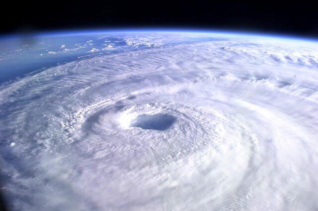
The air moving towards the low pressure (eye of the storm) is deflected, the result is the air spiraling in towards the centre. As the air gets closer to the centre it spirals in tighter and tighter circles. From the conservation of angular momentum we get the air moving faster and faster the closer in it gets. This gives the hurricane the intense wind speeds. Eventually the forces roughly balance out, the forces include the Centrifugal and Coriolis fictitious forces in 3 dimensions, pressure forces in 2 dimensions and friction. The balance of the forces creates the eye of the storm. The forces acting are different at different heights but lets ignore that.
Ok so we have the basics of hurricanes motion but how are they created and what separates them from regular storms?
The first stage of a developing hurricane is an organised cluster of tropical thunderstorms with a mass of cold air above them. This creates an unstable atmosphere as the cold air is generally denser and wants to sink beneath the warm air. This makes convection currents very likely, resulting in updrafts and the movement of moisture upwards creating towering clouds. When these thunderstorms maintain there identity for over 24 hours we have a system that can develop into a hurricane as the system is stable enough to get larger and larger.
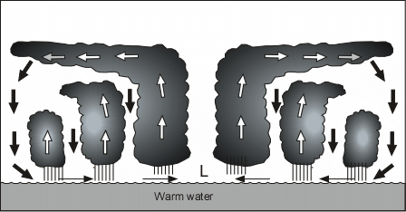
When the cold air starts to sink to the surface it pulls the warm air from the surface up and we get circulation (convection). The warm air has a lot of water vapour from the warm water its over, as this rises the water vapour condenses into liquid water. Latent heat is given off in condensation (energy to change a solid into a liquid or vapour), the heat causes the air to expand causing the horizontal cloud tops. This coupled with the fact that surface air is heated up by the warm water as it moves towards the area of low pressure creates a self building effect. The resulting increase in convection creates lower and lower pressure in the center which will eventually create a pressure gradient large enough (high wind speed) that the Coriolis force comes into play. Cyclonic circulation has begun.
Wind speeds of a minimum of 74mph define a hurricane. Even though it sounds reasonably simple there are many criteria that need to be met for the wind speeds to get so high. I'm not going to list them off but the idea is that the water musty have a high temperature and conditions must allow the continued activity of thunderstorms. There are also ones to do with wind shear and Coriolis requirements but lets skip them.
Thank you for reading. This post is to try raise some money for the people who are affected by this weeks hurricanes, please upvote and resteem.
All steem dollars generated by this will be converted to dollars and donated to charities, no matter if this gets 1 cent or 1000 dollars.