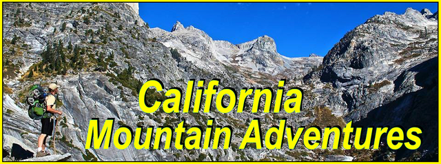
My California - East Fork Thru Hike

For this weeks Show Us Your California contest by @socalsteemit I headed up into the San Gabriel mountains for a 3 day...
East Fork Thru Hike!!

So... I'm a bit late with this one as I've been super busy and haven't had much time for writing, but I finally got some time so here it is! Back in June my buddy Ryan, his brother Ryder, and I all planned to thru hike the East Fork of the San Gabriel river from top to bottom. So Ryan dropped off his truck at the Heaton Flats trailhead at the bottom and then his wife Sophia gave us all a shuttle ride around to the Vincent Gap trailhead at the top. Upon arriving at Vincent Gap we were confronted with the recently controversial situation there where the forest service has given Mt. High, the local Wrightwood ski resort, the authority to charge for parking. It's total corporatism with the forest service selling out our public lands for profit. I hope people keep complaining and keep fighting it because I personally find it disgusting. But without going on a whole rant about it I'll just say that we were able to park right across the highway from the trailhead for free, so the new fee didn't effect us.
At the trailhead we took a few pictures, said goodbye and thank you to Sophia for the ride, and then headed down the trail into Vincent Gulch. It was a beautiful morning hiking down into the canyon through mixed conifer and oak forest, but the bugs were out which was a little annoying, but not surprising for that time of year and it wasn't effecting our excitement at all. About a half mile down we stopped for our first little side adventure where we left the trail and headed over to check out the old Tom Vincent cabin. Tom Vincent was one of the many legendary mining figures from the canyon and he was the man who discovered the famous Big Horn mine which produced lots of gold over it's many years in operation. And although it is well over a hundred years old the forest service has put in some work to keep it standing and you can still visit the old miners cabin today. We checked out the cabin and the surrounding area and took some pictures and then headed back to the trail and continued our decent down into Vincent Gulch. Upon arriving in the bottom of the gulch we found the creek flowing more than I'd ever seen it in all my many trips down this trail. We continued down the trail stopping briefly at the Vincent Gulch camp and then stopping again to check out the remains of a crashed glider plane that has been there since it crash landed there back in the 70's. After checking that out we continued down the gulch to where it met the Prairie fork and then we took another quick break at the Mine Gulch camp between Prairie fork and Mine Gulch. At the Mine gulch camp there is an apple tree that grows there and I have enjoyed apples from it several times in the past. So while we were there I took some time to haul some buckets of water from the creek to water the tree a little. From the Mine Gulch camp there is no trail and so we were just hiking down the river bed from there. As we crossed Mine Gulch we got some views up to the Big Horn mine high up on the hill. Below mine gulch it was lots of river crossings and rock hopping. At one point we came across a couple of deer, but unfortunately we spooked them and they ran away too fast for us to get any pictures. After another mile or so down the river we arrived at our first camp spot for the trip. A nice inside bench covered in Spruce Fir which at one time was the home of Backpack Dave, a more recent mining legend who lived in the canyon for over 17 years. There is not much left of his cabin there, but it's still a great spot to camp. Once we got our camp all setup we headed down to the river for the rest of the afternoon. I did a little gold panning and Ryder tried a little fishing. I only found a few tiny dust sized flakes, and Ryder didn't get any bites, but it was still great just spending time on the river. After that we headed back up to camp and had some drinks and some dinner and enjoyed our first night in the canyon.

Views from the trailhead at Vincent Gap
Pine mountain and Mt. Baldy in the distance

Tom Vincent Cabin


Back on the trail

Views looking up at Mt. Baden Powell

Vincent Gulch camp

The creek in Vincent Gulch

Checking out the glider wreckage

Prairie fork junction
(Vincent Gulch creek left/Prairie Fork right)

The apple tree

Mine Gulch camp

The first of many old mining artifacts

Crossing Mine Gulch

Hiking down river with Iron mountain in the distance

All that's left of Backpack Daves home

A big yucca bloom by our camp

Ryan and Ryder hanging out by the river

Panning for gold
In the morning we woke up, had some breakfast, packed up camp, and then started our second day of hiking down canyon. Day 2 would have no trail at all with lots and lots of river crossings and route finding. We made our way down river eventually getting to the junction with Alder Gulch. We stopped there and did a short side adventure up the gulch where we got to see some mining artifacts that had washed down from the old Bluebird mine as well as a beautiful little waterfall where we stopped for a swim. And Ryder was even brave enough to jump off the cliff into the pool at the base of the falls! After that we continued down river making multiple crossings and trying to avoid the poison oak and stinging nettle as much as possible. At one point we had our first rattlesnake encounter of the trip which was really cool. Eventually we made it to the Fish Fork camp at the junction with the Fish fork. We stopped there for a bit and took our lunch break. Unfortunately the camp has been getting abused. Someone has destroyed the old stone fire place and stone table that used to be there and have also left lots of trash lying around. As a person who has put lots of effort into cleaning up trashed spots like this lower down on the river where it happens more frequently, it was really frustrating to see this type of behavior so far out in the backcountry. To do my part I took a couple pieces of the abandoned gear and strapped it to my pack to hike it out, but unfortunately there is still lots of work that needs to be done to return the Fish Fork camp to it's former glory. Below Fish fork we passed the big waterfall at Falls Gulch and then stopped briefly to check out a cave that is formed from calcium deposits in the water that drips out of an overhanging cliff which I unofficially call the Caliche Cave. Although the cave is not very deep I think both Ryan and Ryder were pretty surprised at how cool it was! Below that we continued navigating our way down river. At one point I slipped and had a pretty rough fall in the river. Luckily nothing too serious, but when I fell, I fell right onto my hiking stick, breaking it in half with my ribs which ended up bruised and painful for the rest of the trip. Eventually we passed the junction with Clark gulch and then made it to our second camp of the trip, my main mining camp just a few bends above the Iron Fork where I have spent a lot of time prospecting over the last 12 years. We got our camp all setup and then I spent some time up in the brush going though my stash, cleaning it up a bit and pulling out a few things for us to use and a few things for me to pack out. While I did that Ryder headed down to the river with his fishing pole and caught his first trout of the trip! After that we made dinner and just relaxed around camp enjoying our second and final night in the canyon.

My tent in the morning

Starting to head down canyon in the morning

Navigating our way down river

Wildflowers


The waterfall in Alder Gulch

Continuing down river

Getting another view of Iron Mountain

The rattlesnake

The junction with Fish Fork
(East Fork left/Fish Fork right)

Falls Gulch falls

Butterflies

Checking out Caliche Cave

Some of the huge stalactites that overhang the Caliche cave

One more shot of Caliche cave

Continuing to navigate our way down the river

Passing Clark Gulch

Continuing down river

Arriving at our second camp

My tent and my wet clothes
In the morning we had breakfast and then started packing up camp and while we were doing that Ryder decided to try a few casts in the river and he ended up catching a couple more trout! Day 3 was gonna be a packed day with lots of things to see and would be about half off trail and half on trail. Once camp was all packed up we started making our way down river and pretty quickly we ran into our second rattlesnake of the trip. After a couple river bends we arrived at the Iron Fork junction and stopped to make the side trek up to the Iron Fork camp which was once the home of George Trogden another mining legend who lived and prospected in the canyon in the early 1900's. We continued down below Iron fork and after a few more bends in the river we arrived at what I believe was the old Stanley-Miller cabin, a storage cabin for the men working the Stanley-Miller mine high up on the slopes of Iron mountain which was later fixed up by the previously mentioned Backpack Dave who made that his first home in the canyon before later relocating to his spot in the upper canyon. After checking out the cabin we continued down into the section known as "the narrows" which as the name would suggest is where the canyon gets narrow with big cliff walls and is probably the most scenic section of the canyon. At the lower end of the narrows we stopped for a lunch/swim/fishing break and Ryder was able to catch multiple trout! After that we started to climb the trail up to the Bridge To Nowhere, a bridge that was built in 1936 as part of a project to build a road across the San Gabriel mountain range, but was abandoned after the big flood of 1938 washed out the road killing hundreds of people but leaving the bridge intact. After crossing the bridge I opted to take us down a spur trail that cuts directly back down to the river instead of taking the main "incline" trail that most hikers use to visit the bridge. Once back down at the river we continued downstream just following the river. We passed by the Annex mine, which was a possible side excursion, but it was already becoming a quite long and tiring day and so I opted to skip it and continue down to the Horseshoe mine. Which I had been to once before but somehow still had a hard time locating it. For some reason I thought it was closer to the Annex mine, but after a few more river bends we found it. We dropped our packs, grabbed our flashlights, and headed into the mine. The mine starts through hardrock and then further in reaches ancient placer deposits which are quite unstable and dangerous. And there was even signs of recent collapses, so although we could've gone farther than we did by crawling through the small tunnels in the placer deposit we opted to stop at the main split, where the mine split into 4 tunnels going up down left and right, just to be safe. And honestly, for me it was already dangerous enough going as deep as we did. After exploring the mine we climbed up onto the high bank just across from the mine to see the ruins of the old Saunders family cabin who were the original owners of the Horseshoe mine as well as the Bridge To Nowhere property. After that we continued down to the junction with Devil's Gulch where we stopped and dropped our packs for one last side excursion up the gulch to Devil's Gulch falls which is probably the most beautiful waterfall in the canyon. Ryan and Ryder were stoked at how awesome it was and couldn't help but to go and get in the natural shower under the falling water. After enjoying the waterfall it was only another half mile or so without trail until we met back up with the main trail. From there the hike out was pretty straightforward. We followed the trail passed Alison Gulch, Swan Rock, and Shoemaker canyon, and then made the last few river crossings eventually arriving at the Heaton Flats campground. From there it was just the last half mile on the dirt road out to the parking lot where Ryans truck was waiting for us. It was an amazing trip and we got to see so much cool stuff, but the truth is we barely scratched the surface as there is so much to see and explore in this incredible canyon!

Heading down river the next morning

Making our way up Iron Fork

The Iron Fork camp

The stone table with 1929 the year of George Trogdens death carved into it

Views of Ross mountain from Iron Fork

Checking out the Stanley-Miller cabin

Ryan relaxing on the swing at the Stanley-Miller cabin

Making our way down into the Narrows

Hiking through the Narrows

Hiking through the Narrows

Hiking though the Narrows

Hiking out the bottom end of the Narrows

Ryder and Ryan enjoying the river during our lunch break

Approaching the Bridge To Nowhere

Views from the bridge

Views off the other side of the bridge with Rattlesnake peak in the distance

Back on the river down below the bridge

The entrance to the Horseshoe mine

Exploring inside the mine

Checking out the ruins from the Saunders family cabin

Some interesting ruins in Devils Gulch

Devils Gulch falls

Swan Rock

In the river just above Heaton Flat

Hiking through Heaton Flats campground

The final view from the parking lot
Besides being an awesome hiker and adventurer Ryan is also a really great videographer and you should definitely check out this excellent video he made of our trip! Not only does it cover the details of our trip, but he gives lots and lots of really interesting history about a lot of the things we saw in the canyon.
Also... if you are interested in learning more about the history of the East Fork as well as other places in the San Gabriel mountains I highly recommend checking out https://angelesadventures.com/ for some of the best and most informative write ups covering all kinds of places and interesting history in the range.
And so until next time...
I hope you have enjoyed this glimpse into
My California!!


#SoCalSteemit is building and supporting the Steemit community of Southern California. If you are from SoCal and are into creating quality content here on Steemit, we'd love for you to follow us @SoCalSteemit and join our group on Discord
An amazing trip! Glad you didn’t get hurt too bad and it is such an amazing spot so close to home. Thanks for sharing! I am going to watch the video soon as well! 😎
Congratulations, your post has been successfully curated by Team 7 via @𝐢𝐫𝐚𝐰𝐚𝐧𝐝𝐞𝐝𝐲