ReadNwrite - A 7 day writing Challenge - How to do anything - plotting of land - olabillions
designed in canva
Today I will be tutoring on how to graphically represent a land on paper, this is my first time creating a post in regards to this, so I will try my best to make it easy, understanding, and simple
To represent a diagram of land on paper, there must have been record of the land in a field book.
what is a field book, it is a book the is used to make records of bearings and distances of any land surveyed.
A bearing is a number in degrees the indicate the direction of a land when traversing and the distance is the measurements taken during the process of traversing a land, while traversing is an act of taking measurements on a piece of land.
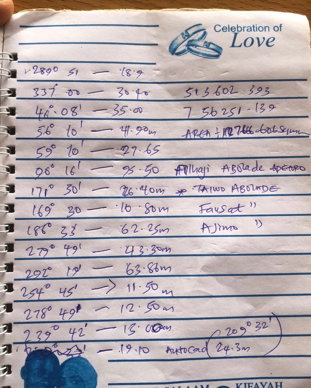
A field book containing bearing and distances
| Bearing(d- degree) (') - seconds) | distance (m) |
|---|---|
| 289d 51’ | 18.9m |
| 337d 00’ | 30.40m |
| 46d 08’ | 35m |
| 56d 10’ | 41.90m |
| 59d 10’ | 27.65m |
| 90d 16’ | 95.50m |
| 171d 30’ | 26.40m |
| 161d 30’ | 10.80m |
| 186d 33’ | 62.25m |
| 279d 49’ | 43.30m |
| 292d 19’ | 63.86m |
| 254d 45’ | 11.50m |
| 278d 49’ | 12.50m |
| 239d 42’ | 13.00m |
| 209d 32’ | 24.30m |
After having such detail of the land, then we proceed to collect other materials like
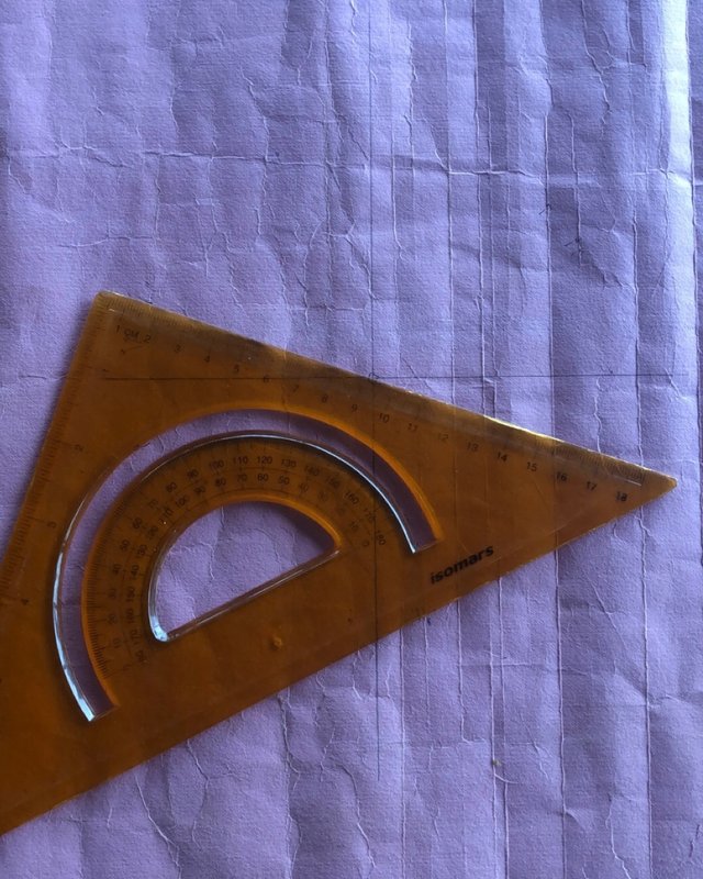
- Paper
- Set square
- Scale
- Eraser
- pencil
- protractor
- pen
Let's proceed on the steps to represent a portion of land, also known as PLOTTING.
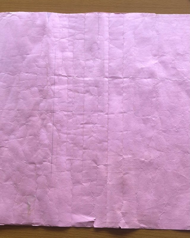
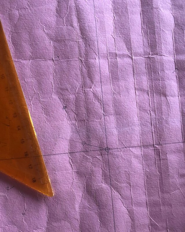
On a table, we spread the paper and use the set square to draw a 4 cardinal points, accurately.
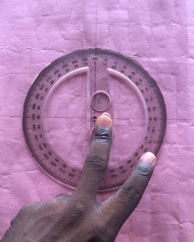
Then the protractor will be placed accurately on the cardinal points.

Maintaining the accuracy with the protractor, we mark every bearing registered from the land on the paper with the help of a protractor. Take a closer look you will see the marked numbers.
Set the set square from the meeting point of the cardinal point to the first bearing marked on the paper, by this the direction his gotten, then after getting an accurate alignment, you draw a line and from the line drawn, you measure the distance(in this case 18.9m) with the scale (1:1000), and at the end of the measurement, you indicate it with a small box which is referred to as the pillar point or station point.
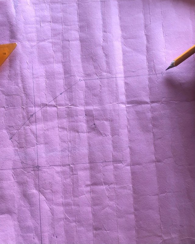
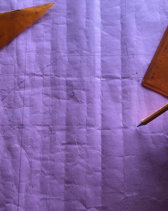
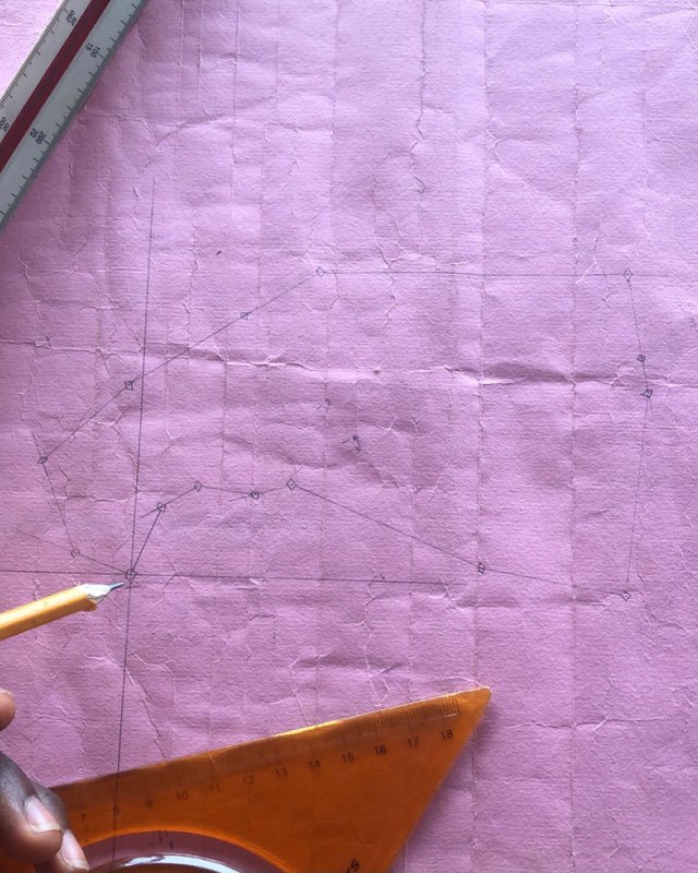
The same implies to other bearings (i mean the alignment of the angle of the cardinal point to other bearings) but the only difference here and which will continue until the last bearing is that after the alignment, we use both set squares and trace to the previous point i.e the previous pillar points, of which this will be continued until the last bearing and distance respectively.
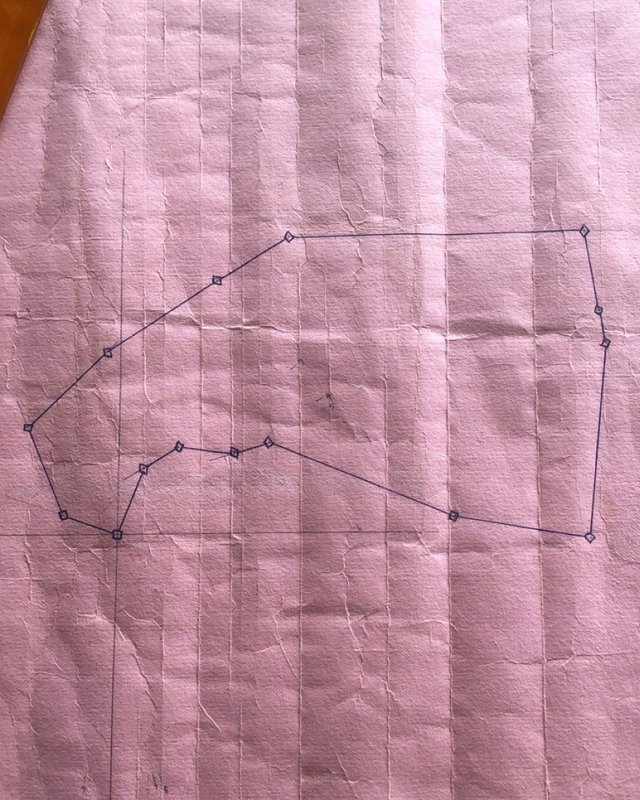
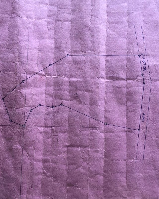
At this point, the whole bearing and distance are already recorded on the paper and a shape is being formed, I then traced the pillar points and distances with a blue pen and also indicated the existing road as it is on the earth's surface.
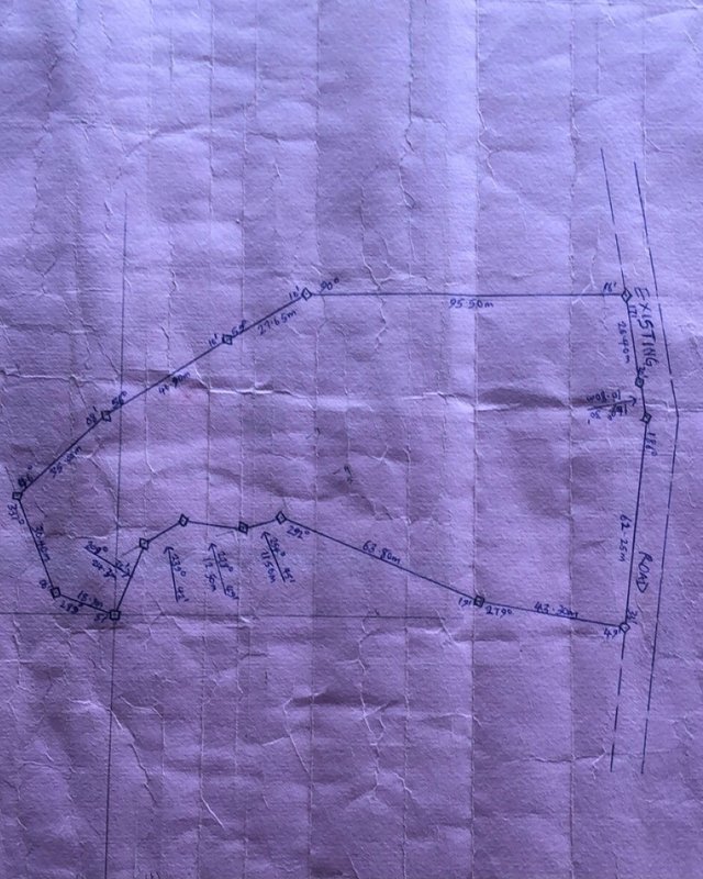
In the end, the bearings and distance will be written respectively.
In my way, I have been able to describe the steps by which you can represent a land on paper.
Greetings and blessings
Written by:- @olabillions
Wow... when I saw the content title, I was thinking the procedures is something easy but I now believe I was wrong. It's as calculative as further maths..😂. Anyways you made a good post hear Billions.
We keep blogging.
💪My brother for a long time, thanks for your comment, it is not so hard as you think, and this is not as hard as further maths
😂😂... maybe it isn't. But those stuffs are little bit confusing.
🤣🤣Watin you no learn go hard for your face
True talk..😂
Thank you for contributing to #LearnWithSteem theme. This post has been upvoted by @Reminiscence01 using @steemcurator09 account. We encourage you to keep publishing quality and original content in the Steemit ecosystem to earn support for your content.
Regards,
Team #Sevengers
Thanks for the support
You have presented a proper guide on how to represent a plant of land on paper.It looks like mapping which we did in high school maths and geography.I have learnt a new thing from your post although I couldn't comprehend everything as a novice that I am.
@olabillions
Checking the rules
Checking Post Quality
Smiles, the kinda look alike tho but a little difference, thanks for the review anyways
Welcome bro
the material we are going to use is not going to be cheaper than that.
wish you the best in this contest.
Congratulations! This article has been manually curated using our community account. Always publish great content, free of plagiarism and make sure you are participating in club5050, club75 or club100. Congratulations once again, hoping to see your next publication soonest!
Thanks for the support always