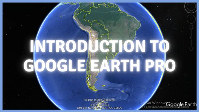
[100% Power Up] ENG - ESP || Introduction to Google Earth Pro / Introducción a Googl Earth Pro
ENGLISH
Hi my dear friends!! Today I want to share this post about Google Earth Pro! I know that this is a well-known software, but maybe some of you don't know about it or you have no idea how much can you do with this, so I will start from the beginning: what is it, how to install it, and what can you do there. I hope you like it!!
What can you do with Google Earth Pro and how to use it?
What is Google Earth Pro?
This is software where you can see the entire Planet Earth by satellite images. This is for free and you can use it both on your laptop as on your cellphone. It has the most updated images and you also can travel back in time to take a look at the same place before. By doing that, you will be able to analyze changes in the territory, s loss of productive land, urban areas expansion, a decrease of the level of the sea, rainforest loss, and more.
What's the difference between Google Earth and Google Earth Pro? You will see the images with the same quality, but the second one allows you to print the images in high resolution.
How can I get it?
You only need to download the app for your mobile phone (this is for Android and for iOS as well), and for your computer (available for PC, Mac, or Linux), you need to follow these simple steps:
Download Google Earth Pro by following this link
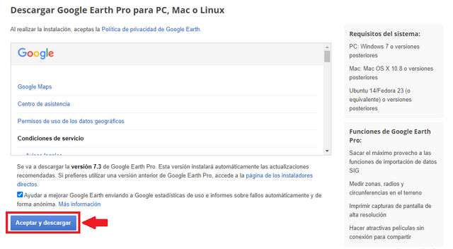
That's what you will see in the link above. Source.
That's in Spanish, but basically, it said:
System Requirements:
PC: Windows 7 or later versions
Mac: Mac OS X 10.8 or later versions
Ubuntu 14 / Fedora 23 (or equivalent) or later versions
Google Earth Pro Features:
Get the most out of GIS data import capabilities
Measure zones, radii, and circumferences on the ground
Print high-resolution screenshots
Make attractive offline movies for sharing
Then, follow the simple steps of installing like any other software or app. The program will guide you easily.
How to start?
You only need to write a place and start analyzing different scales:
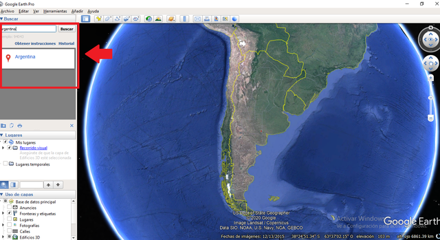
This is Argentina, my country! That's almost regional scale! Regional or national, but I can go to my city too!!
To zoom, just use the wheel of your mouse or make a double click!
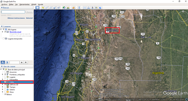
That's my city, Mendoza, and there you can see that I activated the routes tool. You have a lot to do on Google Earth Pro.
And... you can go to a smaller scale, for example:
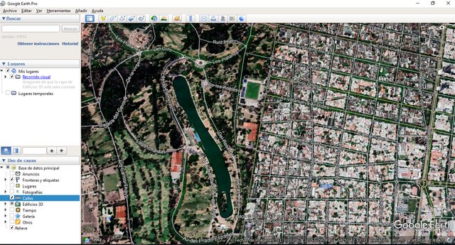
That's a part of Mendoza center, where you can see Parque General San Martín to your left (west).
What else can you do with that software?
Just for mention (because if I write it, this is going to be an extremely long post that you won't read), you also can:
- Draw polygons, place lines, or points in the places you want to.
- Film a video translating from one place to another
- Make an elevation profile
- Watch the same place at night
- Travel in time
- Watch buildings in 3D
- Walk in the streets with Street View
That's an introduction to Google Earth. Personally, I love this software, it is extremely useful when you travel, to analyze cities, planning, and you also can have a lot of fun!!
I hope this has been useful to you!! Please, ask me anything you need!
Greetings
@belenguerra

.png)
ESPAÑOL
Hola mis queridos amigos! Hoy quiero compartir esta publicación sobre Google Earth Pro! Sé que este es un software muy conocido, pero tal vez algunos de ustedes no lo sepan o no tengan idea de cuánto pueden hacer con esto, así que comenzaré desde el principio: qué es, cómo instalarlo y qué puedes hacer allí. Espero que te guste!!
¿Qué puedes hacer con Google Earth Pro y cómo usarlo?
¿Qué es Google Earth Pro?
Este es un software donde podés ver todo el planeta Tierra mediante imágenes satelitales. Esto es gratis y podes usarlo tanto en tu laptop como en tu celular. Tiene las imágenes súper actualizadas y también puedes viajar atrás en el tiempo para echar un vistazo al mismo lugar antes. Al hacer eso, podrás analizar cambios en el territorio, pérdida de tierra productiva, expansión de áreas urbanas, disminución del nivel del mar, pérdida de selva tropical y más.
¿Cuál es la diferencia entre Google Earth y Google Earth Pro? Verás las imágenes con la misma calidad, pero el segundo te permite imprimir las imágenes en alta resolución.
¿Cómo puedo obtenerlo?
Solo necesitas descargar la aplicación para su teléfono móvil (esto es para Android y también para iOS), y para su computadora (disponible para PC, Mac o Linux), debe seguir estos sencillos pasos:
** [Descarga Google Earth Pro siguiendo este enlace] (https://www.google.com/intl/es/earth/download/gep/agree.html) **
Eso es lo que verás en el enlace de arriba. Fuente.
En caso de que no se alcance a leer lo que dicen los recuadros, acá lo comparto::
Requisitos del sistema:
PC: Windows 7 o versiones posteriores
Mac: Mac OS X 10.8 o versiones posteriores
Ubuntu 14 / Fedora 23 (o equivalente) o versiones posteriores
**Funciones de Google Earth Pro: **
Aproveche al máximo las capacidades de importación de datos GIS
Mide zonas, radios y circunferencias en el suelo
Imprime capturas de pantalla de alta resolución
Crea películas atractivas sin conexión para compartir
Luego, siga los sencillos pasos de instalación como cualquier otro software o aplicación. El programa lo guiará fácilmente.
¿Cómo empezar?
Solo necesitas escribir un lugar y comenzar a analizar diferentes escalas:
¡Esto es Argentina, mi país! ¡Eso es casi una escala regional! Regional o nacional, pero yo también puedo ir a mi ciudad!!
Para hacer zoom, simplemente usa la rueda del mouse o hacé doble clic.
Esa es mi ciudad, Mendoza, y ahí pueden ver que activé la herramienta de rutas. Tienes mucho que hacer en Google Earth Pro.
Y ... puedes ir a una escala menor, por ejemplo:
Esa es una parte del centro de Mendoza, donde puede ver el Parque General San Martín a su izquierda (oeste).
¿Qué más puedes hacer con ese software?
Solo por mencionar (porque si lo escribo, esta será una publicación extremadamente larga que no leerás), también podés:
- Dibujar polígonos, colocar líneas o puntos en los lugares que desees.
- Grabar un video traduciéndolo de un lugar a otro
- Hacer perfil de elevación
- Mirar el mismo lugar por la noche
- Viajar en el tiempo
- Ver edificios en 3D
- Caminar por las calles con Street View
Esta es una introducción a Google Earth. Personalmente me encanta este software, es sumamente útil cuando viajas, para analizar ciudades, planificar, ¡y además te puedes divertir mucho!
Espero que esto te haya sido útil !! ¡Pregúntame lo que necesites!
Saludos
@belenguerra

Definitivamente me encanta esta publicación, muy util... Gracias!!
Gracias amiga!! 😊
A very important post. I also got a lot of ideas from this post.
Hello @worldgeography, yo utilizo esto casi a diario po rmi trabajo, es realmente últil, 25 años atrás no imaginaría que podría existir una herramienta tan completa, tan útil y facil de usar, sobre todo porque está al alcance de todos.
Excelente aporte, seguiré visitándolos en busca de novedades.
Saludos y éxitos.
Hola @worldgeography, yo ya aprendi a manejarlo y es estupendo.
Gracias por los tips super útil para conocer una calle un lugar antes de visitarlo.