The Great California Flood Of 1861-1862: How An Atmospheric River Shaped The Golden State

in #history6 years ago (edited)


Image Author: USGS, Image Source. Labeled for public domain and edited by @socalsteemit using GIMP

Welcome everyone! As most of the United States is locked in a sweltering heat wave, it gives an opportunity for @socalsteemit to present a time when the state was literally underwater. As Californians battle with drought, its odd to think that a little more than 150 years ago most of the states' valleys were left with standing water. So sit back, relax, and enjoy this bit of history.

The rain started in the winter of 1861 and continued on into 1862, for four months. A series of atmospheric rivers continually pounded the western United States dumping huge amounts of water in an already drought stricken area. What is an Atmospheric River you say? Well its just as it sounds... a river of water vapor. The National Oceanographic and Atmospheric Association explains:

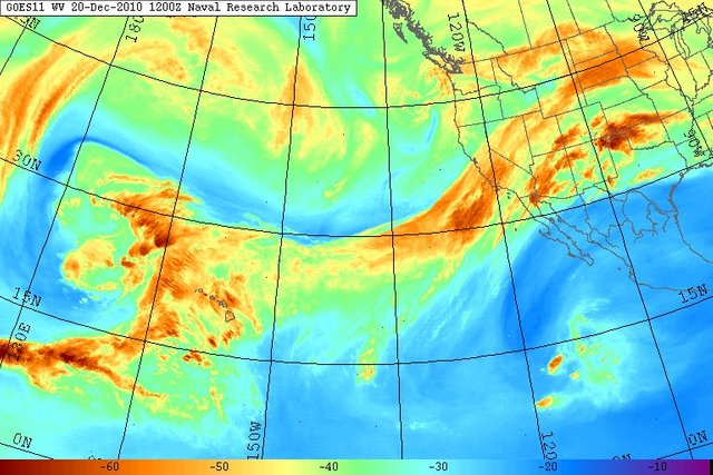
Atmospheric Rivers (ARs) are relatively narrow regions in the atmosphere and are responsible for most of the horizontal transport of water vapor outside of the tropics. While ARs come in many shapes and sizes, those that contain the largest amounts of water vapor, the strongest winds, and stall over watersheds vulnerable to flooding, can create extreme rainfall and floods.

Image Author: United States Naval Research Laboratory, Monterey, Image Source. Labeled For Public Domain

Torrential rain pounded the entire state of California. The Cambria History Exchange has an article Titled The Great Drought that details:

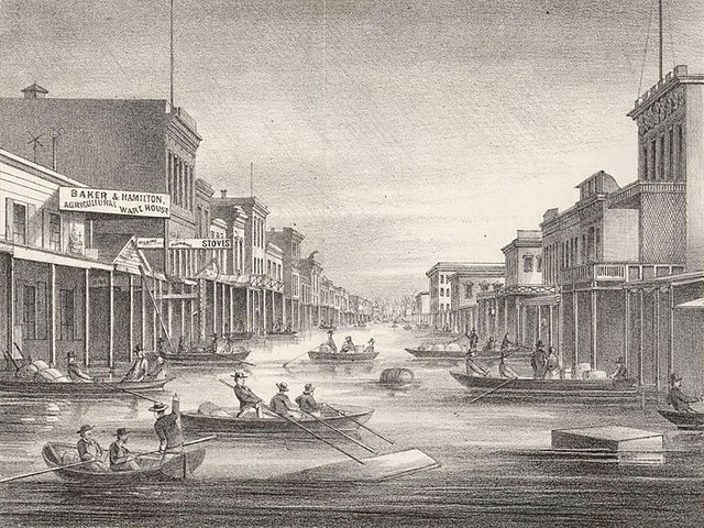
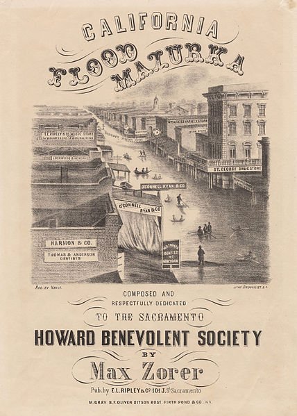
Thirty-five inches fell in the 30 days between December 24, 1861, and January 23, 1862. The Sacramento and San Joaquin valleys, a combined region 250 to 300 miles long and an average of at least twenty miles wide, or probably three to three and a half million acres, was totally under water.

The San Joaquin River Delta, as well as parts of the Central valley, became an inland sea. To the north near the state capital, the flooding was inundating buildings. The American River Watershed Project has an article titled History that describes Native American lore:

Native Americans knew the Sacramento Valley as an inland sea when the rains came. Ancient storytellers told of water filling the valley from the Coast Range to the Sierra.

Downtown Sacramento. Image Author: Rosenfield, A., Image Source. Dated 1862 and Labeled For Public Domain In the United States.


Poster showing the devastation. Image Authors: Drouaillet (active ca. 1860), French?, lithographer (lithographer), Vance, Robert H. (active ca. 1851-ca. 1862), American, photographer (photographer), E.L. Ripley & Co. (active ca. 1860), publisher (publisher). Image Source. Labeled For Public Domain in the United States.

As the gold rush was in full swing, miners in the Sierra Nevada's, hoping to strike it rich were inundated with flood waters. Scientific American has an article written by B. Lynn Ingram on January 1, 2013 titled California Megaflood: Lessons from a Forgotten Catastrophe that goes into detail:

In early December, the Sierra Nevada experienced a series of cold arctic storms that dumped 10 to 15 feet of snow, and these were soon followed by warm atmospheric rivers storms. The series of warm storms swelled the rivers in the Sierra Nevada range so that they became raging torrents, sweeping away entire communities and mining settlements in the foothills—California’s famous “Gold Country.”

Southern California was also hit with torrential rain and most of the missions on river banks were forced to evacuate. The Article by Ingram further elaborates:

Sixty-six inches of rain fell in Los Angeles that year, more than four times the normal annual amount, causing rivers to surge over their banks, spreading muddy water for miles across the arid landscape. Large brown lakes formed on the normally dry plains between Los Angeles and the Pacific Ocean, even covering vast areas of the Mojave Desert. In and around Anaheim, , flooding of the Santa Ana River created an inland sea four feet deep, stretching up to four miles from the river and lasting four weeks.

The city of Eldoradoville, a booming mining town located on the East Fork of the San Gabriel River, was washed completely away in January of 1862 Source.

After the flooding of 1861-1862 The entire state of California was in economic trouble. Curbed San Fransisco has an article by Adam Brinklow Jan 12, 2017 titled The other Big One: California’s pending megaflood explains:

Finance-wise, the storms “bankrupted the state, destroyed the ranching industry, drowned 200,000 head of cattle [and] changed California from a ranching economy to a farming economy” in essentially one stroke, seismologist Lucy Jones told NPR in 2013. The state capital temporarily moved to San Francisco, as Sacramento was navigable only by boat.


Owens Valley from Sawmill Pass. Image Author: Ansel Adams, Image Source. Dated January 1, 1936 and labeled For Public Domain in the United States.

Due to the large loss of local wildlife because of the storms, Some Native American Tribes experienced plight. Militarymuseum.org has an article written by Captain John W. Key, V., U. S. Army Reserve titled The Owens Valley Indian War, 1861-1865 that delves into the history:

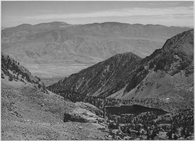
The Owens River valley had been the home of the Paiute Indians for many years; Linguistically, these Indians spoke the Shoshone language and are sometimes referred to as the Paiute Shoshones. They were primarily food gatherers and farmers. They lived on Pinyon Pine nuts, wild hyacinth tubers and yellow nutgrass tubers as well as the larva of a fly that laid its eggs upon the surface of saline Owens Lake. They also lived on deer, Desert big horn sheep, fish and small game.

The winter of 1861-62 was one of the most severe in the history of the Owens Valley. The plight of the Paiutes was exceedingly bad. The bad weather had driven away almost all of the game and had killed what little game remained. Cattle were now beginning to forage on the Indian's fields of wild hyacinth and yellow nutgrass. It seemed only natural to the Paiutes that the cattle could be killed for their own use, since the cattle were feeding on their fields.

This started what became known as the Owens Valley Indian War and spanned several years. The Los Angeles Times has an article written by Louis Sahagun June 02, 2013 titled DWP archaeologists uncover grim chapter in Owens Valley history that touches on this dark time:

But disputes arose as settlers poured into the valley and began ranching on the tribe's pasturelands. U.S. troops were sent to protect the settlers and the land and water they had effectively stolen from the Paiutes. By 1860, the Paiutes' land had been overrun with cattle and sheep. Tensions spiked when Paiutes took down a settler's cow or ox to eat during the severe winter of 1861. During the Owens Valley Indian War, between 1861 and 1866, ranchers — backed by troops — and the Paiutes tried to wipe each other out. Paiute homes and stores of food were destroyed. Paiutes fought back with bows and arrows, and a few guns.

The removal of the local native population allowed mining to thrive in the Owens valley. This forged the future as mining went on unhindered at Cerro Gordo and allowed the city of Los Angeles to thrive. Los Angeles Department of Water and Power would in the future build the California aqueduct and face one of the largest ongoing legal battles the state has ever seen.


Rendition of flooding of 1861-1862. Image Author: USGS, Image Souce. Labeled For Public Domain in the United States.

It was not until recently that researchers were able to piece together the sophisticated puzzle that was the storm system of 1861-1862. The Los Angeles Times has another article on the matter, written by Rong-Gong Lin II Mar 25, 2018 titled The 'nightmare' California flood more dangerous than a huge earthquake that details the what they came up with:

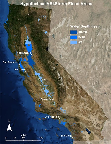
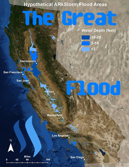
The scenario was dubbed ARkStorm — named for Atmospheric River 1,000 Storm — and published in 2011 after input from more than 100 experts from public and private sectors. The scenario envisions a pounding of California by a series of “atmospheric rivers” — long plumes of water vapor that can pour over the West Coast and hold as much as 15 times the liquid water flowing out of the Mississippi River’s mouth.

Southern California has since experienced other flooding events that may not have put the entire state under water but certainly Southern California. During 1916 , some 50 plus years later, another flood hit dumping tons of water.

The Department of the Interior in conjunction with the USGS came out with a report written by H. D. McGlashan and F. C. Ebert titled Southern California Floods of January 1916 comparing the storm to the previous 1861/62 flooding:

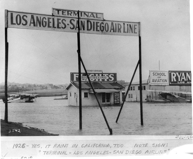
The rains that swept southern California in mid-January, 1916, converted the streams into torrents that overran their banks and devastated wide areas of the most fertile land of the State. The rains were heaviest and the floods most disastrous in San Diego County, but they were also very heavy in parts of Riverside, San Bernardino, Los Angeles, and Ventura counties, and they wrought widespread ruin throughout the region that extends southward from Santa Clara River to the Mexican boundary, and westward from the north-south ranges of San Bernardino and San Diego counties to the ocean. For nearly a month San Diego County was practically cut off from communication with the rest of the State.

More years experienced floods that would inundate Southern California.


Image Author: San Diego Air and Space Museum Archive Flickr, Image Source


Buena Park, 1938. Image Author: Orange County Archives Flickr, Image Source. Creative Commons Attribution 2.0 Generic.

In the last few decades California has been under drought conditions with freak storms sparingly dumping. So much so and for so long that the central valley has been sinking in a geologic process known as subsidence. As all the water that was flooded in the valley is now gone and agriculture is now the dominate force, excessive groundwater pumping has caused the valley floor to sink. The pictures below give a rough example of the subsidence of the San Joaquin valley.


Image Author: USGS, Image Source. Labeled For Public Domain in the United States.


Image Author: Eric Chase 1/25/2010, Image Source. CC BY-SA 3.0

As the drought seems to keep its hold, researchers say that it could be a great flood like the flood of 1861-1862 and not a giant earthquake that could sink the California economy. The Science Alert has an article written by BEC Crew 22 Feb 2017 titled Every 200 Years, California Endures a Flood of Epic Proportions - And This Could Be It that details the problem:

"Geologic evidence shows that truly massive floods, caused by rainfall alone, have occurred in California about every 200 years. The most recent was in 1861, and it bankrupted the state," US Geological Survey hydrologist, Michael D. Dettingeris, and paleoclimatologist B. Lynn Ingram from the University of California, Berkeley wrote in a 2013 Scientific American report. "It has now been 150 years since that calamity, so it appears that California may be due for another episode soon."

So while you survive the heat that is gripping the United States just remember that the clouds could roll in and rains could grip the state for months on end. It has happened before. I hope you enjoyed this bit of history brought to you by @socalsteemit.

#SoCalSteemit is building and supporting the Steemit community of Southern California. If you are from SoCal and are into creating quality content here on Steemit, we'd love for you to follow us @SoCalSteemit and join our group on Discord

Sort:  

Wow great article. I did not know central California could flood like that. Now I am going to go buy a boat.

That’s amazing history. I lost a colleague and his daughter in the flooding this year.

Cal has so much history!

That is some really interesting history! Thanks for sharing all that info. I drive by the old site of Eldoradoville every time I drive up into the East fork, all the history up there is so cool.

Coin Marketplace

STEEM 0.30
TRX 0.12
JST 0.034
BTC 63799.64
ETH 3130.40
USDT 1.00
SBD 3.97