On the non-random distribution of "Impact Craters"
The Trifecta
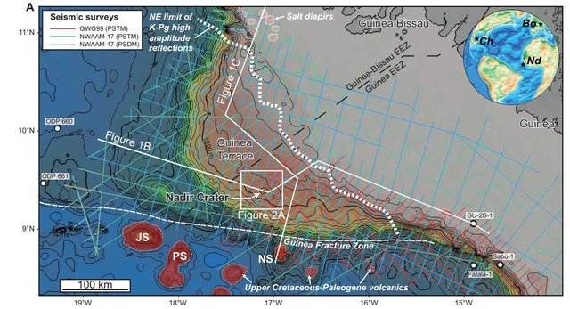
With the recent discovery of the Nadir Crater off the southwestern coast of northern Africa, at the Guinea Terrace, the question of the proximity of craters to the edge of the continental shelf arises.
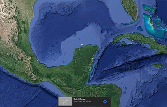
Like the Chicxulub crater, the stratigraphic analysis suggests that the crater formed at or near the Cretaceous-Paleogene boundary, ~66Ma.1 As a result, the authors considered whether it was associated with the Chicxulub crater as binary impact craters. Notably, the Boltysh Crater formed simultaneously and is also considered by Nicholson et al. as a binary or triple impact.
However, again alike to one another, the Chicxulub crater was found generally proximal to the edge of the continental shelf:
While alone this is an odd curiosity, their relatively simultaneous nature makes the proximity to the edge of the continental shelf notable. Then, also considered to have formed in the same time frame of 66Ma is the Shiva Crater2, positioned at the edge of continental shelf as well, making three simultaneous craters formed at the edges of continental shelf:
Moar Craters
They are not the only craters found near the edge of the continental shelf.
Running along the eastern coast of North America, the Chesapeake Bay Crater, Toms Canyon Crater, and Montagnais Craters each are considered to have formed 35.7Ma, 35.7Ma, and 51Ma, respectively.3 More, the Montagnais crater is curiously positioned at a bend in the edge of the continental shelf.
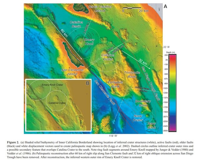
Then, off the coast of San Diego, large enigmatic crater structures were discovered in bathymetry data4:
Figure 2 of Legg et al.
As described by Legg et al.:
"...data reveal large, distinct near-circulate crater structures in the Inner Continental Borderland offshore southern California. Two have maximum crater diameters that exceed 30 km and a third has a crater diameter of approximately 12 km. All three features exhibit the morphology of large complex craters (raised outer rim, ring moat and central uplift) yet their exact origin remains a mystery...Timing of crater formation post-dates the initial rifting and rotation of the western Transverse Ranges, and appears to predate major right slip along the San Clemente and San Diego Trough fault systems--or approximately 18 to 16 Ma."
Significantly, they describe that "the craters lie entirely within the Inner Borderland Rift," strongly suggestive of a relationship between the craters and the local processes both before and after their formations.
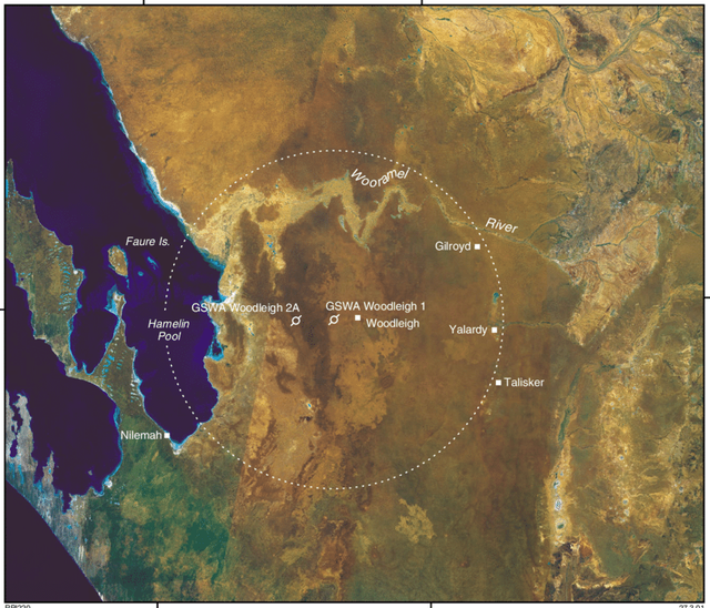
The Woodleigh Crater, the largest crater in Australia, can be found relatively near to the edge of the continental shelf, compared to its diameter:
The Mjølnir Crater, considered to have formed ~150 Ma, appears to be in line with the direction the energy was propagating when the North America and Europe were severed around 200-150 Ma. Though it is not as close to the edge of the continental shelf as the others, it appears to be suggestive of a possible mechanism or contributing cause to the structures--energy propagating in the region being caused to funnel through particular channels.

Similarly, the Popigai crater is positioned near where continental shelf and the propagating fracture meet and the continent experienced a force:

More, Popigai is considered to have formed ~35.7 Ma, making it the same age as the Chesapeake Bay and Toms Canyon craters discussed above, and it has been considered for links between the formation of the craters,5 similarly producing another trifecta of simultaneous continental shelf coastal "impact craters" being formed.
Its positioning and the shape of the continental shelf is suggestive of a larger polygonal structure that the Popigai crater lies along:


The structure carving through the polygon towards it's heart, from the southwestern region, is reminiscent of Mount Girnar's also southwestern fracture line that is at a 90 degree angle relative to the ridge branching from the central mountain:
What Is Really Going On?
In a sense, these "impact craters" are like blow-out valves in the structure of the Earth itself that allowed energy accumulating in regions to be expelled through point locations.
As there are three separate sets of trinary craters all on edges of continental shelf and both distributed globally and more locally, these are not random and thus cannot be impact craters from outer space as traditionally viewed. Rather, they can only be similar structures from internal impact processes caused by the Earth itself.
This energy propagating through regions being the result of a vortex weapon used on Ancient Dwarka that caused the Earth to expand....
- Nicholson et al., The Nadir Crater offshore West Africa: A candidate Cretaceous-Paleogene impact structure, Science Advances, Vol. 8, No. 33, Aug 2022.
- Chatterjee et al., "Shiva structure: a possible KT boundary impact crater on the western shelf of India, Special Publications, Museum Texas Tech University, January 2006
- Poag et al., Ancient impact strucutres on modern continental shelves: The Chesapeake Bay, Montagnais, and Toms Canyon craters, Atlantic margin of North America, December 2002, Deep Sea Research Part II Topical Studies in Oceanography 49(6):1081-1102
- Mark R. Legg, Craig Nicholson, Chris Goldfinger, Randall Milstein, Marc J. Kamerling, Large enigmatic crater structures offshore southern California, Geophysical Journal International, Volume 159, Issue 2, November 2004, Pages 803–815
- DEUTSCH, A. and KOEBERL, C. (2006), Establishing the link between the Chesapeake Bay impact structure and the North American tektite strewn field: The Sr-Nd isotopic evidence. Meteoritics & Planetary Science, 41: 689-703.


