Edo in Tokyo (2-5) 5Kaido (東京の中の江戸2-5:日本橋-五街道):For anybody interested in Japan & its history/culture (005E)
As eexplained in the previous post, water transportation in the Edo Peiod
using canals was the infrastructure for their economy and even for living.
The river banks as Nihonbashi, Kyobashi and Hatchobori, near Edo-Castle
were the center and key points of the entire network. Many merchants
gathered and developed the area, keeping their headquater even now as
"Mitsukoshi" or "Takashimaya". Three big festivals in Tokyo written in the
next post, have all been supported by residents in this area.
先の号でご紹介のように、江戸時代、運河での水運は市民生活の基盤の
インフラであり、江戸城に近い、河岸は重要な経済・商業の中心でした。
その中でも”日本橋”は京橋、八丁堀と並んで、一番の拠点で、豪商たちが
多数集まっていました。 その名残が今でも、百貨店の三越や高島屋の
本店所在地となっている他、多くの卸商・専門店がこの地域に軒を
連ねています。 その他、次号でご紹介予定の江戸三大祭りの、深川・
神田・山王祭りは、日本橋の商人たちが氏子として歴史的にも支えて
いるものです。
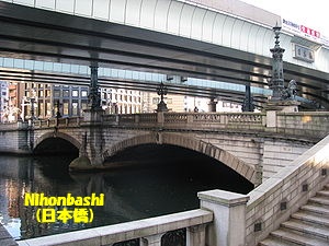
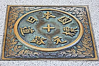
Nihonbashi was not only the key place for water transportation, but also the
key point of road network in Edo Period and even at present.
The map below shows five essential roads in Edo Pedriod all starts from
Nihonbashi. Even now the mark of Japanese Zelo Kilometer is placed at
Nihonbashi. In Edo Period, Government of politics was in Edo, however the
Emperor still lived in Kyoto, and thus the roads between Edo and Kyoto namely
Tokaido and Naskasendo were very busy. Also various clans governed their
own territory and roads between Edo and local area also needed to be well
prepared. The following is the outline of each five road;
日本橋は江戸期の水運の拠点だけでなく、当時から陸路の拠点とも
なっており、下記の五街道の始点でしたし、現在でも”日本国道路元標”が
置かれ、全国道路網の基点となっています。 江戸時代、行政の中心の
幕府は江戸にあったのですが、天皇は京都の御所に居られ、江戸と京都の
間、或いは商業の中心となっていた大阪との間の交通は重要なものでし
たし、その他の街道も各地の諸藩との交流の上で、重要なインフラで
あった筈です。 以下に簡単に五街道の概要を示します。

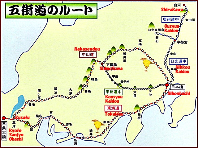
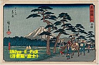
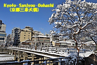
1)Tokaidou
From Nihonbashi to Kyoto Sanjyo Ohashi, about 490 kilometer having 53 "Syukuba"
(Post Town). Fifty Three "Syukuba" was famous because often mentioned in
novels and also painted by renowned artist as Hiroshige and Hokusai.
Edo Government seemed to consider Fifty Seven Shukuba including four from Kyoto
to Osaka more important than Fifty Three. As Tokaido is critical from military
aspect, Edo Government built the barrier at Hakone to control in and out of
people.
東海道
江戸日本橋~京都三条大橋の間、約490kmで53の宿場が設けられ、一般に浮世絵
や小説等で”五十三次”として知られたが、幕府は大阪まで含めた57次を重要視
したとの説もある。 東海道は幕府にとって政治・軍事的な意味も大きく、有名
な”箱根の関”設けて、江戸からの出入りを管理した。
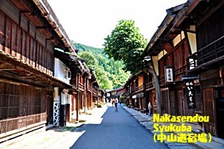
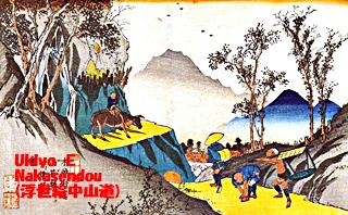
2)Nakasendou
Nihonbashi to Sanjyo Ohashi, but via inland area while Tokaido is the coastline.
Total length is about 53 kilometer, having 69 Syukuba mostly through mountain
area. Kusatsu~Kyoto is the same road as Tokaido. At Shimosuwa, it joined
KousyuKaidou. Nakasendou had harder places comparing to rather flat Tokaidou,
but many people seemed to use Nakasendo to avoid trouble with control of
administration, also hotel bill was some 20% cheaper than that of Tokaido.
中山道
江戸日本橋~京都三条大橋の間で東海道と始点・終点は同じだが、内陸部を通り、
距離は約530kmで69の宿場が設けられた。 草津‐京都間は東海道と共通、後述の
甲州街道とは長野の諏訪で合流する。 山道で難所も多かったが、管理の厳しい
東海道を避けて、中山道を選ぶ旅人も多かった由、又各宿場間の距離も短め、宿賃
も東海道より2割程度安かったとのことである。
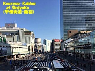
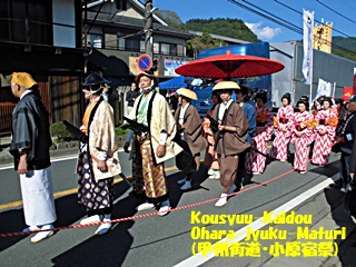
3)Kousyukaidou
Nihonbashi to Shimosuwa about 220km having 39 Shukuba. Koufu was considered
the emergency shelter of Edo Government, and also at that time, gold was
yielded there, this road seemed so important that two barriers were built,
within rather short distance and the special force guarded the road.
Only three Daimyo used this road when come and go from their territory to Edo,
while all other Daimyo travel Nakasendo.
甲州街道
江戸日本橋~下諏訪間、約220kmに39の宿場。 短い距離だが、江戸幕府の退避場所
とされ、且つ幕府貨幣制度の金貨が産出地でもあり、街道が当時は関所も2か所、
鉄砲組が配置される等、特別な街道で参勤交代でも、三藩しか利用せず、他は中山道
となっていたそうである。
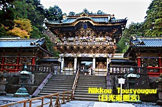
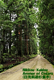
4)Nikkoukaidou
NIhonbashi to Nikko Tousyouguu where Ieyasu Tokugawa was enshrined, about 130km
having 21 Shukuba. From Nihonbashi to Utsunnomiya, was in common with
Ousyukaidou. The purpose of this road was said to use for Shogun to
pilgrimage to Tousyouguu but the road was there before Toushouguu. Thanks to
short distance, tour by normal public to Tousyouguu was popular, using this
road.
日光街道
江戸日本橋~日光東照宮間、約130kmで21宿場が置かれた。日本橋~宇都宮間は奥州
街道と共通。 主に将軍の日光東照宮参拝に利用の為との説もあるが、実際は家康
自身により街道が整備されている。 宇都宮を奥州諸藩に対する備えとする為との
説もある。 江戸時代、距離的に近い点もあり、庶民の旅行も盛んだったようである
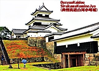
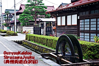
5)Ousyuukaidou
Apart from overlapping portion of Nihonbashi to Utsunomiya, Ousyuukaidou is
usually pointed the road between Utsunomiya and Shirakawa, but the entire
distance was 190km both portion together, with 27 Shukuba.
As Edo grew, traffic from and to Edo and Mutsu (Tohoku) and also Ezo
(Hokkaido) become thriving and as the relay point, Shirakawa became No2
city next to Utsunomiya, that why this road was badly needed to prepare.
奥州街道
宇都宮~白河が奥州街道と呼ばれるが、実際は日本橋~白河間、約190kmで27宿場を
指すともされる。 江戸期、江戸と陸奥(青森)や蝦夷(北海道)との交易が増え、
白河が中継点として人口も宇都宮に次ぐ多さとなった為の整備とされる。
It may be a fun to visit Nihonbashi, thinking of the bank in Edo period and
longing far place like Kyoto-Osaka or Touhoku-Hokkaido.
日本橋に立って、京・大阪を思ったり、遥か東北・北海道の江戸期の光景に想いを馳せる
のも一興かと思います。
Hi ~ I'm a robot of red2018.I just upvoted your post!
Please come visit me here: https://steemit.com/@red2018
Thanks so much~!!
Thank you very much! You may be in France?