PLANET EARTH - NATURAL TERRESTRIAL SURFACE & GEOID
Hey everyone!
How's everything going? I sincerely hope each and everyone of you had a wonderful time during the week. I've been extremely busy the past few days and it's been rather exhausting so I'm currently looking forward to the weekend. As I've mentioned before, to me weekends are all about friends and family. A walk in the mountains, a cup of coffee and conversations about the Universe and Eternity are always on my to do list. Which is exactly how I'm going to spend this weekend, taking a break from the platform and science as well. Well, at least for a couple hours. Needless to say I'm back in business with another engineering blog. I could see it coming. And yes, I'm in a hurry again! Let's do this!
For those of you who just tuned in, I have successfully completed my Introduction to Geodesy series and therefore I've already started sharing advanced technical information regarding this specific scientific field. As always, I'm taking the chance to share historical information regarding the development of the science of measuring our green home's shape and size. I will also share information about the Natural Terrestrial Surface, which is comprised of the Earth's topographic surface and the surface of the oceans. Moreover, we will discuss detailed information about the Geoid, which is a surface of equivalent gravitational force used in Geodesy, so stay tuned!
I'd like to clarify once again that these are not introductory posts. This means we will be discussing advanced information about very specific aspects of Engineering or Geodesy in particular in each blog. I will soon launch another two introductory series about Cartography and Photogrammetry respectively; two different scientific fields that I love. Oh, come on man! Leave us alone! No more fun and games though, so let's get this started. You might learn a thing or two by reading this blog, so stay with me!

Image Source: pixabay.com
History
Hipparchus of Nicaea (190BC. - 120BC.) is considered as the greatest astronomer of all time despite the fact that he embraced Aristotle's geocentric theory. Hipparchus was the very first one to ever talk about the use of galactic and astronomical coordinates regarding the definition of objects' locations. He was the very first one to express the notion that there can be no geographical research without the utilization of astronomical methods in order to achieve high precision regarding distance. Hipparchus improved Archimedes' diopter which was used to calculate the observed diameter of the Sun and Moon, as well as the altitude of various known stars on the horizon. It's also worth noting that Hipparchus was a great inventor, with the flat and spherical astrolabes being two different types of this amazing invention of his. The astrolabe is a sophisticated mechanism that was used to calculate the trajectory and location of various known stars.
.png)
Astrolabe./Image Source: commons.wikimedia.org
Heron of Alexandria (10AD. - 70AD.) was an engineer and mathematician who was rather interested in Geometry instead of Geodesy. Heron's significant work was saved in his writings that still exist nowadays. Detailed information regarding methods and techniques of calculating angles and distances with extreme precision as well as the engraving of significant technical constructions is included in his valuable writings. Heron perfected the diopter as an instrument which was mostly being used in measuring angles and invented the odometer, an instrument that proved to be very useful in measuring distances with accuracy. Last but never least, Heron calculated and verified the time interval needed for the planet to revolve around the Sun with an estimation error of less than 4 minutes. Mind boggling. He also verified that the four seasons on Earth are not equal in terms of duration and determined meridians and parallels. He was such a restless man that he also authored a catalogue with more than 800 known stars including coordinates, names and dimensions.
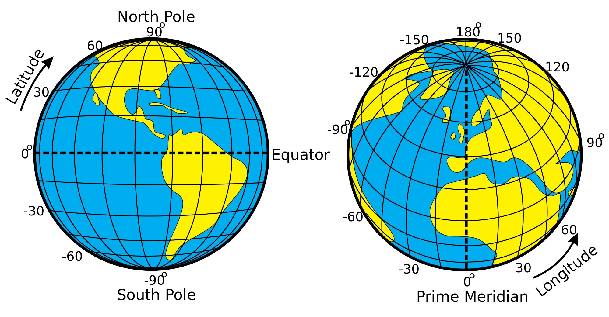
Meridians & Parallels./Image Source: commons.wikimedia.org
Claudius Ptolemaeus (100AD. - 170AD.) was another significant figure. He was a famous geographer, cartographer, astronomer and mathematician that lived and worked in the city of Alexandria in Egypt. He was the very first one to compose a sort of encyclopedia that contained all astronomy knowledge possessed by the Greeks back then. Claudius was a supporter of the geocentric theory who embraced Ipparchus' beliefs and left a legacy of astronomical and geographical writings. His famous work titled 'Mathematical Syntax' consists of 13 books and was translated in arabic during the 9th century. Claudius also built a geographical atlas which consisted of 8 books and 27 maps, with geographical coordinates and names of more than 8000 known cities included. The greco-roman astronomer was such an influential figure that his writings started being used as university textbooks for centuries, after byzantine scholars introduced his writings to the West during the 15th century.
Image Source: pixabay.com
Natural Terrestrial Surface
The Natural Terrestrial Surface is the planet's real surface and includes the topographic surface and the surface of the oceans. It is considered as the imaginary boundary between land or sea and the planet's atmosphere and therefore the Natural Terrestrial Surface is the main subject of research in Geodesy. The Earth's topographic surface is much easier to be observed and, therefore, measured as it is indeed the surface on which the human civilization resides and thrives. Needless to say all geodetic observations and measurements take place on the Natural Terrestrial Surface with the creation of geodetic reference systems as mentioned in a previous post. The only direction applied in nature is the direction of gravitational pull which is always vertical, as a result geodetic instruments and measurements are directly affected by the direction of gravity and the precision of the geodetic reference system.
The surface of the sea has been used as the reference surface utilized by engineers in order to measure orthometric altitudes and sea depths mainly for practical reasons. However the constant change in shape and altitude of the sea's instantaneous surface induced the need for the utilization of another reference surface with a more stable behaviour and shape. As a result, engineers started using the average sea level as a surface that was more suitable for the calculation of the orthometric altitude of points on the Earth's surface. The average sea level is changing periodically on a yearly basis mainly due to the change of temperature followed by the succession of the Earth's four seasons, which is caused by the Earth's rotary axis' slope of 23,2 degrees in regards to the planet's ecliptic trajectory, as mentioned in a previous post. However the change of temperature is not the only cause of change for the average sea level as it is directly affected by the atmospheric pressure and various meteorological factors.
Image Source: pixabay.com
The average sea level is also affected by factors with systematic activity such as the melting of ice caps due to global warming and the constant alteration of the ocean basins' floor due to geological reasons. It has been estimated that the average sea level has risen about 100m over the past 20 000 years, mainly because of the melting of icebergs and ice caps. Nowadays' rate of increase regarding the average sea level is approximately 1-2mm per year for the Mediterranean region. The average sea level is calculated with the utilization of advanced instruments that record any changes in levels in specific time intervals. It is worth noting that this method can only be applied in areas close to the coastline, whereas in different cases the average sea level is calculated with the utilization of artificial satellites which measure their distance from the surface of the sea in given locations by using special radar technology. Nowadays it is possible to calculate the average sea level in all parts of the ocean with a precision of a few centimeters. In conclusion, the average sea level resembles a surface of equivalent gravitational force with an abstention of slightly more than 1 meter. It is therefore safe to say that the average sea level materializes the Geoid with a precision of 1m, which brings us to our next chapter.
The Geoid
The Geoid is a surface of equivalent gravitational force with a shape that resembles the shape of the average sea level. In fact the Geoid coincides with the average sea level at an approximate abstention of 1 meter in oceanic areas of the globe and is assumed to expand beneath the Earth's continents through imaginary tunnels. However there are cases in which the average sea level does not coincide with any surface of equivalent gravitational force. This is mainly caused by differences in temperature and/or salinity of the water as well as the successive flow of currents in the ocean. It is a known fact that the Geoid is a closed surface that resembles a rotated ellipsoid with a maximum abstention of 100 meters, which is also known as altitude of the Geoid (N). This abstention is equivalent to 15 x 10^-9 x R , R being the radius of the Geoid. It is therefore obvious that this abstention is comparatively small, while the average abstention for the entire planet is approximately 30 meters. The dictionary definition of the Geoid clarifies the fact that the direction of gravitational pull is always vertical to the surface of the Geoid regardless of position.
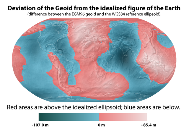
Deviation of the Geoid./ Image Source: commons.wikimedia.org
The Geoid is the reference surface utilized in every astronomical reference system. It is also the reference surface regarding orthometric altitudes (H), which basically means that a specific point on the Earth's surface has an orthometric altitude that is measured as the point's vertical distance from the average sea level. The precise calculation and definition of the Geoid has always been a point of massive interest and maybe the primary objective in Geodesy. Engineers' measurements regarding our home planet's surface, shape and size are directly affected by the precision accomplished by the reference systems utilized. Therefore it is obvious that it all comes down to the precise definition of the reference surfaces used; any errors could induce a domino effect of successive errors in calculations which in turn could ruin constructions, estimations and even measurements. Engineers accomplish the desired precision when building a reference surface by utilizing geodetic, astronomical, oceanographic and obviously gravitational measurements. The ever increasing quality of instruments used along with the constant improvement of documentation in theories provide grounds for even higher precision.
It is worth noting at this point that the use of satellites offers significant contribution towards achieving great precision nowadays. Since the Geoid actually resembles a rotated ellipsoid, which is one of the reasons why it is often referred to as a spheroid, it was actually inevitable that Engineers would desperately look for that specific rotated ellipsoid which coincides perfectly with the Geoid in terms of shape and size, has the exact same amount of mass as the Earth and at the same time represents a surface of equivalent gravitational pull of itself. This specific sort of rotated ellipsoid can be defined with the utilization of two different parameters: its two semi axes. It can be used to substitute the Geoid, which is a complex mathematical surface that therefore is hard to be precisely described using mathematical formulas. This ellipsoid can also be used as a reference surface that could be utilized by Engineers in order to calculate and define not only the Geoid but also a variety of geodetic, topographic and cartographic quantities. As a result, this rotated ellipsoid is also known as reference ellipsoid or Earth ellipsoid. It is worth mentioning that for any specific point on the Earth's surface the geometric altitude is measured as that specific point's vertical distance form the reference ellipsoid.
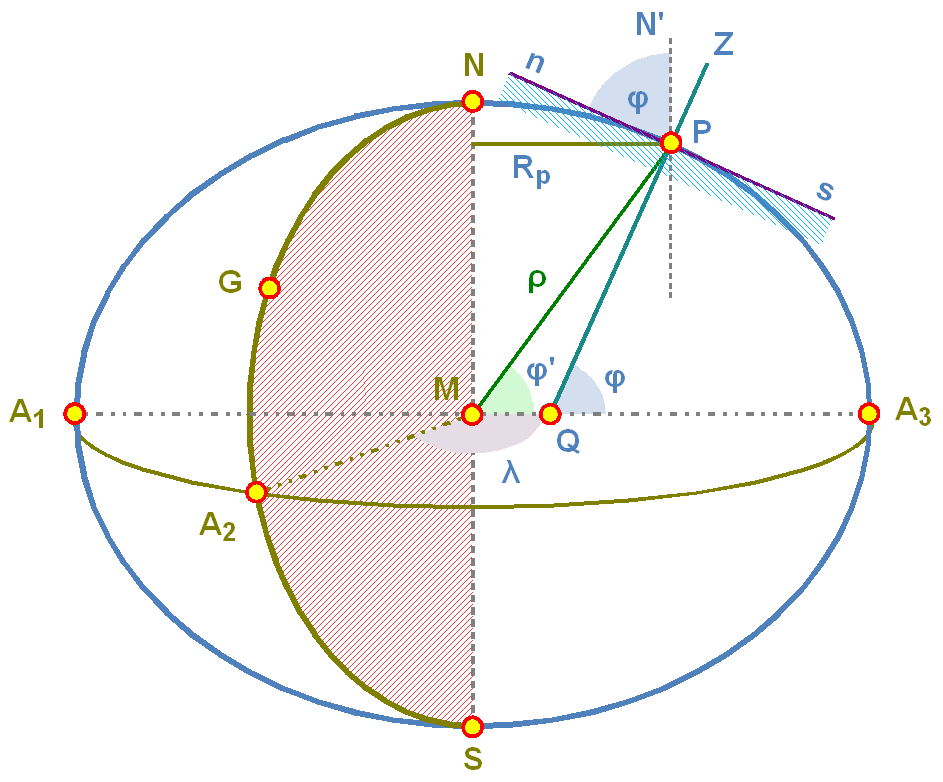
Geoid and Astronomical Coordinates./ Image Source: commons.wikimedia.org
Hope you made it till the end! Another Engineering - Geodesy post comes to an end! I sincerely hope you enjoyed this and did learn a thing or two. If you do have any questions, feel free to let me know in the comments below and I will do my best to respond promptly and precisely. Geodesy never ends, however I will start blogging about various scientific fields such as Photogrammetry and Cartography as mentioned in my introduction. You might want to stick around as there's a high chance of learning a thing or two by following me! Stay safe, blessed and tuned! :)
IMAGE SOURCES:
REFERENCES:
University Textbooks & Lecture Notes:
Eισαγωγή στη Γεωδαισία/Ιntroduction to Geodesy - TELIONI ELISSAVET(National Technical University of Athens, School of Rural and Surveying Engineering,Course Lectures)
Δορυφορική Γεωδαισία/Satellite Geodesy - ΜILAS PARASKEVAS(National Technical University of Athens, School of Rural and Surveying Engineering,Course Lectures.)
Aνώτερη Γεωδαισία/Τοp Geodesics - BITHAS ANASTASIOS(National Technical University of Athens, School of Rural & Surveying Engineering,Course Lectures)
Internet Links:
Thank you for your attention!
Hope you enjoyed this post!
I'm glad if you did learn a thing or two.
Follow me and stay tuned for more engineering blogs.
Highest Regards
@lordneroo


Dear @lordneroo, I finally took the time to visit your blog, get to know your (excellent) writing and your passion. In this post, I mostly enjoyed the history part :) It was fascinating learning about Heron of Alexandria’s accuracy on the Earth’s revolving around the sun, and Claudius Ptolemaeus pioneering works writing encyclopaedias.
I will be interested in following your intro series about Cartography :)
All the best 🌷😊
@abigail-dantes Thank you so much for taking the time to read my post. I appreciate that!
Heron was a bright dude indeed. It's worth noting that he assumed there should be a slope of the Earth's rotary axis in regards to the planet's ecliptic trajectory, which is true and is the very reason we have four seasons on Earth. However the first one to ever express the notion that the Earth was actually revolving around the Sun was Aristarchus and not Copernicus, as explained in a previous post. If you were fascinated by the fact that Heron made such a precise estimation at around 50AD. , you might enjoy reading a previous post of mine to find out how Eratosthenes managed to calculate the Earth's circumference and radius in 235BC. with great precision by utilizing observations of the shadows casted by different objects located in different cities.
Again, thanks for dropping by and reading my work! I will definitely launch a series of introductory posts regarding Cartography and I'm more than glad to know you would be interested in following.
Thanks for the support and the kind words!
Have a great day! :)
Highest Regards
@lordneroo
Do the tectonic activities going on at the ocean basins really affect the rise in sea level, because the ocean floor undergoes steady recycling, there is active tectonism which causes the ocean floor surface to be filled with much younger rocks than the continental surface.
I think the main reason for the rise in the sea level is due to the melting of the ice caps leading to expansion in volume.
Also with this high rise in sea level over the years, what do you think is the best remedy for global warming so as to avoid a major transgression in the nearest future.
Hi there! Thanks for reading!
The planet's tectonic activity does affect the average sea level in a systematic manner. That is basically due to the fact that tectonic plates often collide with each other (or even move away from each other) and as a result the shape of the ocean basins changes significantly, which in turn affects the average sea level. The way this process affects the average sea level is not unilateral.
Τhe melting of the ice caps is undoubtedly the most significant factor causing the average sea level to rise. As you rightly pointed out this process definitely leads to expansion in volume. Regarding the best course of action humanity could take, I believe that reducing greenhouse gas emissions could work wonders. However that's highly unlikely as it means we would have to stop using fossil fuels and I can't see that happening any time soon. However do keep in mind that global warming is also fueled by solar activity which is not constant and is definitely influencing the climate on Earth.
Hope you found this comment useful!
Thanks for dropping by!
Highest Regards
@lordneroo