Palm Sunday Unspringlike Snow Showers Chilly Day Warmer Week Ahead
Palm Sunday Unspringlike Snow Showers Chilly Day Warmer Week Ahead
<iframe style="border: none;" src="//rcm-na.amazon-adsystem.com/e/cm?o=1&p=12&l=ez&f=ifr&linkID=431c1e7be66bc52a4e7193969dcff192&t=meteorologisj-20&tracking_id=meteorologisj-20" width="300" height="250" frameborder="0" marginwidth="0" scrolling="no"></iframe>
Palm Sunday Unspringlike Snow Showers Chilly Day
Warmer Week Ahead
Long Island is sitting in a lot of cloud cover today. On the satellite picture below we can see lots of clouds over Southeastern Canada & New Foundland. A large upper air storm is dominating the flow up and down the east coast. It is forcing a storm off the South Atlantic coast to move to the east and well to our south so we don't have another noreaster issue. However upper air disturbances are swinging around the backside of the low to the northeast. Some snow showers are possible later today into this evening. There are actually a few scattered around this morning on the radar.
US SATELLITE


You can see the snow showers backing in from the northeast which is pretty unusual. Don't panic if you see a few flakes. They won't amount to much. Temperatures on Long Island today will be just in the 40s and the wind will make it feel colder than that. Skies will clear out later tonight as the atmosphere relaxes and lows will be in the upper 20s and lower 30s.
WARMER WEATHER AHEAD FOR LONG ISLAND BUT WATCH THE WIND DIRECTION
The first part of the week will be chilly with some sunshine Monday and sun and arriving clouds on Tuesday with highs both days in the 40s. Warmer weather will try to move in Wednesday and Thursday but the spring season is a frustrating one temperature wise here as a south wind off a cold ocean means temperatures that have a tough time getting out of the 40s which may be the case on Wednesday.
WEDNESDAY'S FORECAST HIGH TEMPERATURES

Wednesday we will see clouds and some breaks of sunshine as low pressure goes by to our north and we wait for a warm front to push on through. How much sun will depend on how stubborn the warm from is. Most of the showers with that front should pass by to our north.
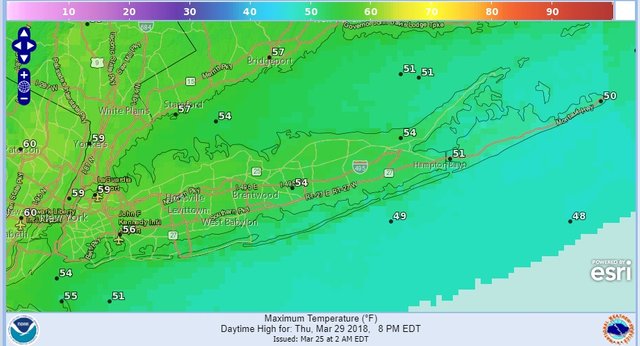
THURSDAY'S FORECAST HIGH TEMPERATURES

Thursday we see a better chance for highs into the 50s as a cold front approaches and the wind turns more southwest which allows a better chance for a warmup. There is also a better chance for showers later Thursday into Friday as the front stalls out and a wave develops on that front. Once that goes by weather conditions should improve for Easter Weekend.
FiOS1 News Weather Forecast For Long Island
FiOS1 News Weather Forecast For New Jersey
FiOS1 News Weather Forecast For Hudson Valley
NATIONAL WEATHER SERVICE SNOW FORECASTS
JOIN JOESTRADAMUS ON YOUTUBE!
LATEST JOESTRADAMUS ON THE LONG RANGE
<iframe style="border: none; overflow: hidden;" src="https://www.facebook.com/plugins/post.php?href=https%3A%2F%2Fwww.facebook.com%2Fmeteorologistjoecioffi%2Fposts%2F10160293154820387&width=500" width="500" height="547" frameborder="0" scrolling="no"></iframe>
Posted from my blog with SteemPress : https://www.weatherlongisland.com/palm-sunday-unspringlike-snow-showers-chilly-day-warmer-week-ahead/