Tropical Update NYC Short Range Forecast
Tropical Update NYC Short Range Forecast
Good morning everyone and welcome to your first tropical update for the season. Activity is starting to ramp up a bit; and while social media has been passing around the image of a model depicting a major hurricane near Florida next in 9 days, we're going to take a step back and give you a more measured approach.
SATELLITE

Tomorrow, we repeat with more sunshine, but the humidity will slowly climb throughout the day. It won't be uncomfortable, but there will be a slight difference as an light onshore fetch develops. Highs tomorrow in the mid 80's, with a few upper 80's dotting the area. With that light onshore flow, it might be one of those days where the gnats and no-see-ums are biting hard at the beaches and bays.

Your weekend remains looking NYC typical for this time of year. Expect a very warm and humid day on Saturday with the slight chance of an afternoon thunderstorm; highs in the upper 80's. Sunday will be mostly sunny and hot, with upper 80's to low 90's.
I continue to think we start next week on a very warm to hot note, but there are questions as to how long it lasts. For now, I'll say we take the upper 80's to low 90's into mid-week at minimum, then introduce more moisture and frontal-action in the area. That remains to be seen though and we'll turn to the tropics for a bit as things are getting more active.
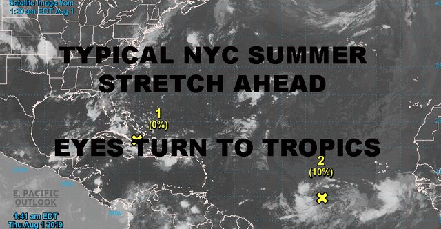
Some models yesterday had a major hurricane off of Florida by next Saturday (Aug 10) and social media went wild. We have to be careful with things like that, because there are so many factors and hurdles in between for something to make it all this way.
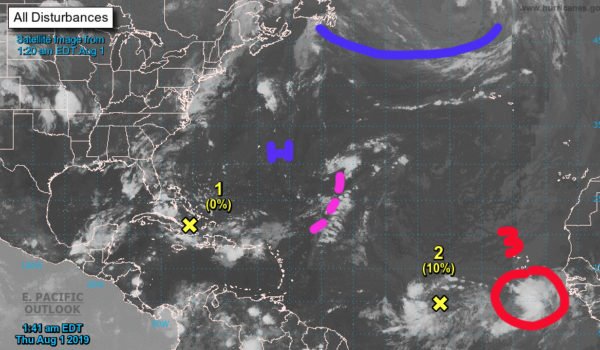
The wave featured on the map that the GFS was depicting is wave #2. The only thing we can do at this point is keep a close eye on it. As of now, the environment is very hostile for developing, with a low pressure trough ahead of it that could shear it to pieces before it gets into a more favorable environment. IF it can hold together somewhat and make it into more favorable atmosphere, THEN we will watch more closely. There is also a fairly strong wave behind it which I circled in red, and that one bears watching as well (as does almost every wave that comes off of Africa).
All in all, we are slowly working our way up to peak season in the tropics, which is typically late August into September. What we are seeing is normal in terms of the increase in action by the Cape Verde island area.
Please note that with regards to any tropical storms or hurricanes, should a storm be threatening, please consult your local National Weather Service office or your local government officials about what action you should be taking to protect life and property.
Posted from my blog with SteemPress : https://www.nycweathernow.com/tropical-update-nyc-short-range-forecast/