SYSTEM PATH REMAINS UNFAVORABLE FOR NYC SNOWSTORMS
DOWNLOAD MY NEW FREE JOESTRADAMUS WEATHER APP FOR ALL DEVICES
(Unsupported https://www.facebook.com/plugins/post.php?href=https%3A%2F%2Fwww.facebook.com%2Fmeteorologistjoecioffi%2Fposts%2F10161417866420387&width=500)
SYSTEM PATH REMAINS UNFAVORABLE FOR NYC SNOWSTORMS
Good morning everyone. Sunny skies and slightly above normal temps resume today, then milder air pushes in for a one-day show tomorrow. In other news, the long range is looking uneventful for snow lovers, and the clock is ticking fast on February.

It won't be as windy as yesterday, but a steady breeze will keep things feeling much cooler today. Sunny skies and low to mid 40's will help finish off any slush piles left over from Sleet Monster, then we really warm up tomorrow.
A frontal system will move into the area tomorrow, taking most of its energy well north and west of us. Expect more clouds than sun, but a light southerly fetch will help propel us into the low to mid 50's. In the process, we'll have the slight chance of a shower or two, but nothing big to write home about.

For your weekend, Saturday may not be 100% dry as a weak disturbance slips to the south of us. We'll have clouds and sun again, with the slight chance of a rain or snow shower during the afternoon; highs in the upper 30's to low 40's.
Sunday's system is looking flat, arrives late, and is a very fast mover; so expect a sunny and dry Sunday with increasing clouds late, highs in the upper 30's. We'll have a very slight chance of light snow or light rain (depending on the final path) Sunday night, then it's all gone (if it happens at all) Monday early morning. Highs Monday in the upper 30's again.

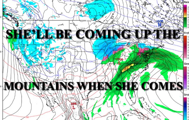
Looking into mid-week and all of the buzz surrounding our next larger system, things aren't looking very snowstorm-friendly at the moment. As of now, it looks like another system coming up from our southwest and moving northeast through the Appalachians to our west.
With relatively cold air dug, we might start out as a bit of snow, but then changing to rain as things progress. Unless we get an energy transfer to the coast off of Maryland, it'll be impossible to hold onto the snow for long, if we even get any snow at all.
Things continue to look hostile atmosphere-wise for an all out, late February snowstorm. That brings us into March where even more questions arise in terms of what our pattern does. Cold air is still available if something wants to get together perfectly, but can it happen.....so the clock ticks.

Please note that with regards to any tropical storms or hurricanes, should a storm be threatening, please consult your local National Weather Service office or your local government officials about what action you should be taking to protect life and property.
Posted from my blog with SteemPress : https://www.nycweathernow.com/system-path-remains-unfavorable-for-nyc-snowstorms/