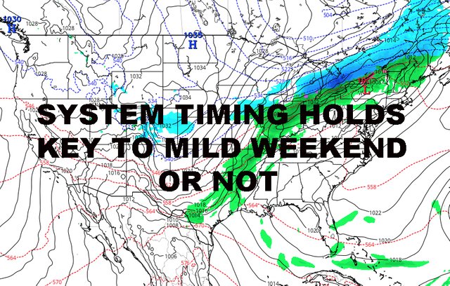
NYC WEEKEND MILD SHOT HANGS ON SYSTEM TIMING AND POSITION
DOWNLOAD MY NEW FREE JOESTRADAMUS WEATHER APP FOR ALL DEVICES
(Unsupported https://www.facebook.com/plugins/post.php?href=https%3A%2F%2Fwww.facebook.com%2Fmeteorologistjoecioffi%2Fposts%2F10161417866420387&width=500)
NYC WEEKEND MILD SHOT HANGS ON SYSTEM TIMING AND POSITION
Good morning everyone. We have a cloudy and raw day ahead today before we dry out and cool off temporarily. We're getting into the time of year where cool air modifies quickly, but milder days can be fleeting also, before being replaced with average temps.

Expect light rain and mist to be scattered about, especially this morning. High temps are where you see them right now, with upper 40's and low 50's dotting the area. Overnight, we'll have another chance of some light rain and mist, and as chilly air moves in, we'll see colder mist or a flurry. It's inconsequential and if we do see a flake or two, it'll be while most of us are sleeping. No accumulation is expected.
One concern I do have however that's not being discussed, is the early morning commute for those who hit the road before sunrise. Be aware of the possibility for patches of black ice as we dip below the freezing mark in most of the area.

Tomorrow, we dip below average as we dry out and bring back the sun. A steady northerly flow will keep things feeling chilly, but it doesn't last very long. Highs in the mid 40's.
Winds settle down on Wednesday and begin to switch away from north. We'll be in the mid to upper 40's, but it won't feel as cool to the skin with the help of the late March sun.
We bounce back nice on Thursday as we should get one more day of full sun before our next system begins to make its slow approach. Look for mid, possibly upper 50's depending on the wind profile.

As we approach the weekend, confidence remains high that we go mild for Friday with 60-65 degree temps. With a front approaching, I don't think we see full sun, but we'll use the words "sun and clouds" for now until we see how fast this system gets here.
Timing will be key to see if we eek out another mild one for Saturday or maybe even Sunday. As mentioned yesterday, if we stay mild for Sunday, then Saturday will probably be the mildest of the 3 day stretch. For now, I remain conservative and keep Saturday in the 60 degree realm, but we could go higher (possibly 65-70) depending on where that front is and if our marine layer is a factor or not.
Sunday I'm not touching yet even if other outlets are.

Overall, I remain very happy with how the long range is holding up, as well as our approach into early April. We are looking very very typical and average; nothing fantastic, nothing historic.
Please note that with regards to any tropical storms or hurricanes, should a storm be threatening, please consult your local National Weather Service office or your local government officials about what action you should be taking to protect life and property.
Posted from my blog with SteemPress : https://www.nycweathernow.com/nyc-weekend-mild-shot-hangs-on-system-timing-and-position/