NYC Toasty Monday Tuesday Before Thunderstorm Threat Wednesday
NYC Toasty Monday Tuesday Before Thunderstorm Threat Wednesday
Good morning everyone. We have a very warm to hot duo ahead of us today and tomorrow before we change things up a bit in the form of showers and storms. Relief is looking brief through as we may start warming things back up again and introducing more humidity late weekend.
SATELLITE

Tomorrow we go for a repeat, with a humid upper 80's to low 90's and the chance of a popcorn storm again.

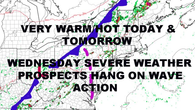
Wednesday is where things get more interesting and more complicated. What was looking like a fairly definitive and fast moving front last week, has taken more of your typical, slow moving, and less definitive cold front. At first, most of the energy will go to the north of us and well up into Canada. However, the front lags behind and we have to watch for the formation of any waves ahead of and/or attached to the front.
For the moment, we're going to call for sun and clouds, very humid, the chance of a shower or storm at any time during the day, then that chance increasing as we get into the evening hours. Highs 85-90.
If the formation, position, and timing of a wave brings something into our area, we will increase the chance for severe weather; so we will be keeping an eye on the entire picture Wednesday into Thursday morning.

I think on Thursday, we begin to clear out and dry out by mid to late afternoon. No washouts are expected, but we could get a few leftover showers or rumbles early; highs in the mid to upper 80's.
Friday continues to look like the most pleasant and dry day of the bunch, with sunny skies, relatively low humidity, and seasonable temps in the mid 80's.

Saturday looks like a transition day as we go from seasonable and dry to very warm with increasing humidity. With transition will come the chance of a storm or two, but we're way too far away on this. If that happens, Sunday could be the start of another 2-3 day very warm/hot block before relief comes again mid/late week next week.
Let's focus on Wednesday's weather first, then we will breakdown the weekend.
Please note that with regards to any tropical storms or hurricanes, should a storm be threatening, please consult your local National Weather Service office or your local government officials about what action you should be taking to protect life and property.
Posted from my blog with SteemPress : https://www.nycweathernow.com/nyc-toasty-monday-tuesday-before-thunderstorm-threat-wednesday/