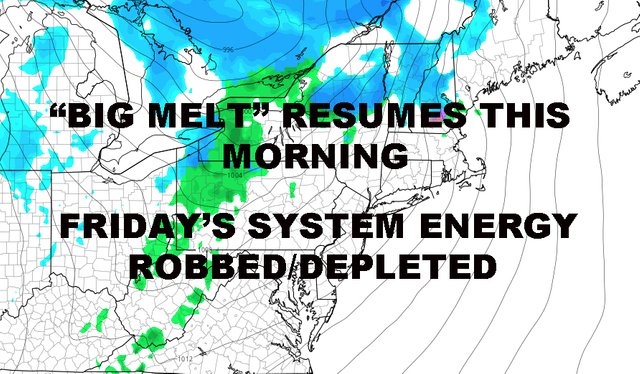
NYC MELT RESUMES TODAY FRIDAY SYSTEM LOOKING WEAK
DOWNLOAD MY NEW FREE JOESTRADAMUS WEATHER APP FOR ALL DEVICES
(Unsupported https://www.facebook.com/plugins/post.php?href=https%3A%2F%2Fwww.facebook.com%2Fmeteorologistjoecioffi%2Fposts%2F10161417866420387&width=500)
NYC MELT RESUMES TODAY FRIDAY SYSTEM LOOKING WEAK
Good morning everyone. The rest of Sleet Monster melts today as we warm up a little bit higher than average in the NYC area. Meanwhile, Friday's system is looking very weak and we have another small, late-weekend system that we'll be watching for any possible flakes.

Look for sunny skies, windy conditions, and highs in the mid 40's today. Overnight tonight, we dip down into he low to mid 20's, so be careful of any standing water that may freeze. Whatever is left should dry up tomorrow as sun returns along with mid 40's and much less wind.

For Friday, the system that was supposed to give us some decent rain is essentially canceled. There's nothing left for the atmosphere to work with after our current departing system clears out 100% from the Northeast.
The good thing is two-fold. First, we don't have to talk about flood watches with only brief, light rain expected. Any flooding that would've occurred, really would've been from this past system saturating the ground, not from anything crazy from Friday's system; but nonetheless, that threat is gone.
Second, it gives us a pretty nice day with light southerlies. Expect clouds and sun, the slight chance of a few showers (most of the action will go well north), highs in the low to mid 50's.

On Saturday, colder air moves back in as we slide back towards normal. Expect sunny skies and highs in the upper 30's to near 40.
Clouds move in with our next system on Sunday as low pressure comes out of the midwest and into the Ohio Valley. What happens then will be crucial as to what type of precip we see. First and foremost, this does not look like a major system, but we could see some flakes in the area.
For now, it's looking like we could see a brief period of snow changing to rain. What happens after that will dictate if we see mixing and back to snow as everything departs, or if it stays all rain. If energy from the primary low doesn't transfer towards somewhere off of the coast, warm air will remain dominant and that's that.
Regardless and at this point, I don't see a major system on our hands.

In the long range, it looks like the pattern tries to hold onto a flake-friendly cycle for a few more days past this weekend, but then things snap back towards our old rainy path.
Time will tell and March is coming!
Please note that with regards to any tropical storms or hurricanes, should a storm be threatening, please consult your local National Weather Service office or your local government officials about what action you should be taking to protect life and property.
Posted from my blog with SteemPress : https://www.nycweathernow.com/nyc-melt-resumes-today-friday-system-looking-weak/