NYC FROZEN PRECIP POSSIBLE TOMORROW NIGHT PLUS CHRISTMAS OUTLOOK
NYC FROZEN PRECIP POSSIBLE TOMORROW NIGHT PLUS CHRISTMAS OUTLOOK
Good morning everyone. Saturday gloom is locked into the New York City area as the chance of some wintry precip remains tomorrow night as everything pulls away. Also, we'll have 1 system, maybe 2, to deal with just before Christmas Day.
EASTERN SATELLITE

As expected, our large, stretched-out system is having a hard time making it very far north. This will keep rain totals down, but it'll do nothing to clear the gloom. Look for on and off spotty light rain, fog, and drizzle throughout the day. Highs will be in the upper 40's to low 50's, but a NE wind will help chop down any resemblance of warmth in the air.

Overnight tonight, the chance of rain increases as things get more organized and it's able to push back on that dry air. I still don't see any heavy rain in sight, but we could have some periods of moderate rain, especially after midnight.
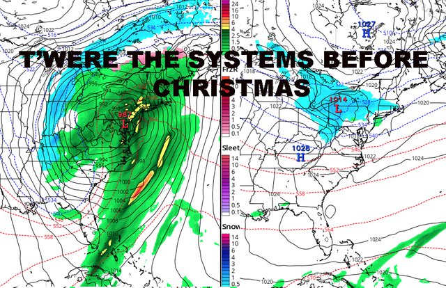
Tomorrow, the steadier rain ceases back to spotty drizzle/light rain, but colder air begins to move in; highs only in the upper 30's to near 40, making any rain the chilly variety. Overnight tomorrow, we'll have one more piece of energy to deal with, but cold enough air could be drawn down from the middler-layers of the atmosphere to mix any rain with sleet and snow.
This will especially be the case N&W of the City, where freezing rain could be an issue for a while before some brief flakes could fly.

To start next week, we'll have a cloudy start on Monday before clearing slowly ensues. A brisk west wind will make any 40's feel like 30's for most of the area. Then, 30's to near 40 temps and dry conditions return for midweek.

As we near Christmas, we'll have a rather large system to deal with. However, our system path remains hostile towards measurable snow here in New York City. Believe me when I say, there's plenty of cold air to tap, but you can't get any snow (aside from onset snow) with low pressure going to our west.
Unlike this weekend's system, next weeks seems to have no problem racing north. So as of now, we could get the staple 1-2" rain which comes with that path.
Our only hope of any flakes before Christmas, will come in the form of a possible Alberta Clipper-like system next weekend. However, this is wayyyy too far out and we'll have to just watch it. As of now, areas N&W have the slight chance of a cheap thrill on or just before Christmas Eve day, and bears watching for the NYC area.
FiOS1 News Weather Forecast For New Jersey
FiOS1 News Weather Forecast For Hudson Valley
NATIONAL WEATHER SERVICE SNOW FORECASTS
JOIN JOESTRADAMUS ON YOUTUBE!
LATEST JOESTRADAMUS ON THE LONG RANGE
Posted from my blog with SteemPress : https://www.nycweathernow.com/nyc-frozen-precip-possible-tomorrow-night-plus-christmas-outlook/