NYC Feels Hurricane Dorian Fringe Effects Today Tonight
NYC Feels Hurricane Dorian Fringe Effects Today Tonight
Good morning everyone. While the maps light up with warnings and all sorts of hyperbole on the news, I want you to close your eyes for a moment. Take a deep breath, relax, and pretend we are in late November. There's a powerful Nor'Easter that just misses us, but close enough to give us some clouds, showers, a stiff breeze, enhanced tides, and rough surf.
That's it.
If you were able to picture that without being scared of losing everything, you've successfully pictured what will happen today/tonight, nothing major.
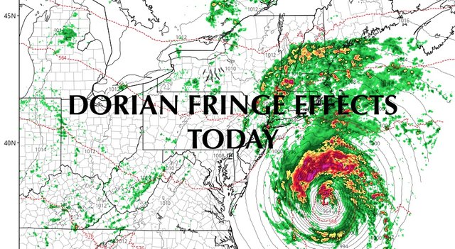
SATELLITE

Clouds are here today with no prospect of sun whatsoever. Hurricane Dorian continues to pound the Carolinas, specifically the Outer Banks in which are about to experience a landfalling Cat 1 Hurricane. He's finally on the move to the NE at 14mph and that speed will increase even more as the day wears on. The outer-most precipitation bands are just south of our area, so expect some brief gusty showers throughout the day, rough surf, and minor/moderate coastal flooding. Highs today near 70.
Again with the Nor'easter reference, if you live an a coastal area that sees flooding during a Nor'easter and spring tide, you could see some nuisance flooding here as well. With coastal flood advisories up, that should be your cue to move the car away from flood-prone areas; such as parts of the Rockaways, Broad Channel, the canals & bay side of West Park in Long Beach, Freeport, Baldwin, Lindenhurst, and other notorious spots throughout Long Island. If you know your street gets water in these situations, take the proper precautions to protect property, but this is not a life threatening situation.
As far as wind and precipitation, the further east you go, the better shot at some steadier rain and stronger winds. The strongest winds will be experienced on the Forks of Long Island, and even so, we're looking at sustained winds of approx. 25mph and gusts to near 40, especially during any shower activity.
The further west you go, the weaker it'll be.

We clear out tomorrow for a beautiful weekend, with clearing skies tomorrow, full sunshine on Sunday, and highs in the mid to upper 70's both days.

Slightly cooler air works in for Monday, but sunny skies remain; highs in the low 70's. We'll modify a bit ahead of a new system, but keep the sun again for Tuesday. Highs in the mid 70's.
We should get back into the upper 70's for Wednesday and Thursday, with slightly more humid conditions on Wednesday, and we'll have the slight chance of showers each day.
Once Dorian passes and we see if it jolts the jet stream or not, we'll discuss the long range as far as what to expect towards the first day of Fall. My spidey-sense tells me that even though we'll have some cool days on tap, we could have a warm entry into fall or at least close to it.

Please note that with regards to any tropical storms or hurricanes, should a storm be threatening, please consult your local National Weather Service office or your local government officials about what action you should be taking to protect life and property.
Posted from my blog with SteemPress : https://www.nycweathernow.com/nyc-feels-hurricane-dorian-fringe-effects-today-tonight/