NYC Cold Air Coming Forecast Questions Remain
NYC Cold Air Coming Forecast Questions Remain
Good morning everyone. We have a fairly quiet week ahead until we get towards Thursday and Friday, which is when that cold air starts to make its approach and head in. Things get a little bit complicated at that point, but I don't foresee anything major going on as far as widespread, accumulating snow in the NYC/Long Island area.
SATELLITE

We'll cloud up tonight, then have more clouds than sun tomorrow and a slight chance of some light showers. This represents a reinforcing shot of cool air, but not before we go for upper 50's to low 60's tomorrow.

On Wednesday, we cool off again with sunny conditions, a steady northwest flow, and highs in the low 50's. After that, things get a little complicated.
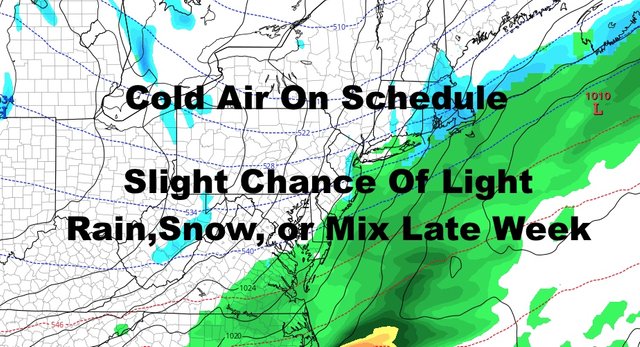
The first part is easy as we'll increase the clouds ahead of our next system. We'll have some morning sun on Thursday, followed by lowering and thickening clouds, and the chance of some afternoon or evening rain. Highs will be in the mid to upper 50's, then drop sharply at night. Overnight, we might hold onto enough moisture as that cold air bleeds into the area. If you're up, you could see some wet flakes mixing in with the rain.
I don't see that system in the south heading into our area, but that cold front could be slow enough to leave or have some moisture leftover behind it in the morning on Friday. With cold air locking in, we could see a light rain/snow mix or some wet snow before everything clears out. Highs Friday in the upper 30's to low 40's, so nothing is sticking even if we do see a few flakes.
Again, nothing major, but it's still a tough forecast at this point and we could simply wind up with nothing at all.

To me, Friday night and Saturday will be the big story as we plunge into the 20's overnight Friday, even in the NYC area. Any crops leftover outside will be done unless they can take it. For Saturday, sunny skies won't do much and we'll repeat Friday's highs of upper 30's to low 40's; giving us temps 15-20 degrees below average.
Thankfully, we modify quickly on Sunday but remain on the cool side. Sunny and dry conditions continue with highs in the upper 40's to low 50's.

As stated yesterday, we are not remotely done with the cold air and our new pattern will flex its muscles in the upcoming weeks. Look for another fairly vigorous system to come through early to mid next week, reinforcing that cold air once again, and giving us another taste of temps like Friday/Saturday.
Please note that with regards to any tropical storms or hurricanes, should a storm be threatening, please consult your local National Weather Service office or your local government officials about what action you should be taking to protect life and property.
Posted from my blog with SteemPress : https://www.nycweathernow.com/nyc-cold-air-coming-forecast-questions-remain/